Items Similar to Antique Chart of the US Population in 1870, published in 1874

Want more images or videos?
Request additional images or videos from the seller
1 of 6
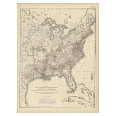
Antique Chart of the US Population in 1870, published in 1874
About the Item
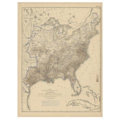
Antique chart titled 'Map showing, in five degrees of density, the distribution, within the territory of the United States, of the constitutional population, i.e., excluding Indians not taxed. Compiled from the returns of population at the ninth census of the United States, 1870. By Francis A. Walker. To which is added a sketch of the principal Indian reservations and ranges from information furnished by the Office of Indian Affairs of date 1871'. Chart of the US population in 1870. Originates from 'Statistical Atlas of the United States based on the results of the ninth census 1870 (..)' by Francis A. Walker.
- Dimensions:Height: 21.66 in (55 cm)Width: 31.11 in (79 cm)Depth: 0.02 in (0.5 mm)
- Materials and Techniques:
- Period:
- Date of Manufacture:1874
- Condition:Original folding line. General age-related toning, minor wear. Blank verso, please study image carefully.
- Seller Location:Langweer, NL
- Reference Number:Seller: BG-11875-371stDibs: LU3054319792472
About the Seller
5.0
Recognized Seller
These prestigious sellers are industry leaders and represent the highest echelon for item quality and design.
Platinum Seller
Premium sellers with a 4.7+ rating and 24-hour response times
Established in 2009
1stDibs seller since 2017
2,412 sales on 1stDibs
Typical response time: 1 hour
- ShippingRetrieving quote...Shipping from: Langweer, Netherlands
- Return Policy
Authenticity Guarantee
In the unlikely event there’s an issue with an item’s authenticity, contact us within 1 year for a full refund. DetailsMoney-Back Guarantee
If your item is not as described, is damaged in transit, or does not arrive, contact us within 7 days for a full refund. Details24-Hour Cancellation
You have a 24-hour grace period in which to reconsider your purchase, with no questions asked.Vetted Professional Sellers
Our world-class sellers must adhere to strict standards for service and quality, maintaining the integrity of our listings.Price-Match Guarantee
If you find that a seller listed the same item for a lower price elsewhere, we’ll match it.Trusted Global Delivery
Our best-in-class carrier network provides specialized shipping options worldwide, including custom delivery.More From This Seller
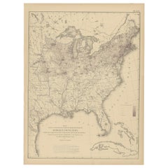
View AllPl. 25 Antique Chart of the US Foreign Population in 1870, '1874'
Located in Langweer, NL
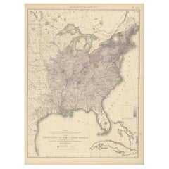
Antique chart titled 'Map showing five degrees of density the distribution of the foreign population within the territory of the United States east of the 100th Meridian. Compiled fr...
Category
Antique Late 19th Century Maps
Materials
Paper
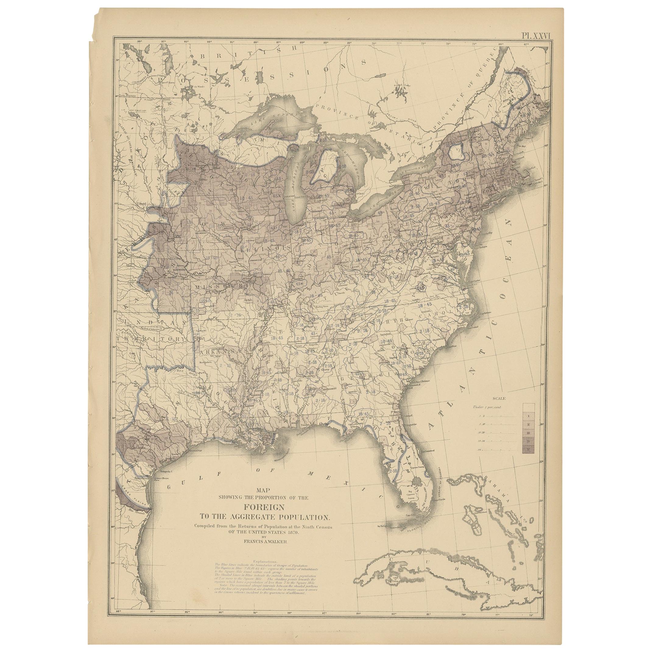
Pl. 26 Antique Chart of the US Foreign Population Proportion in 1870, '1874'
Located in Langweer, NL
Antique chart titled 'Map showing the proportion of the foreign to the aggregate population. Compiled from the returns of population at the ninth census of the United States 1870'. C...
Category
Antique Late 19th Century Maps
Materials
Paper
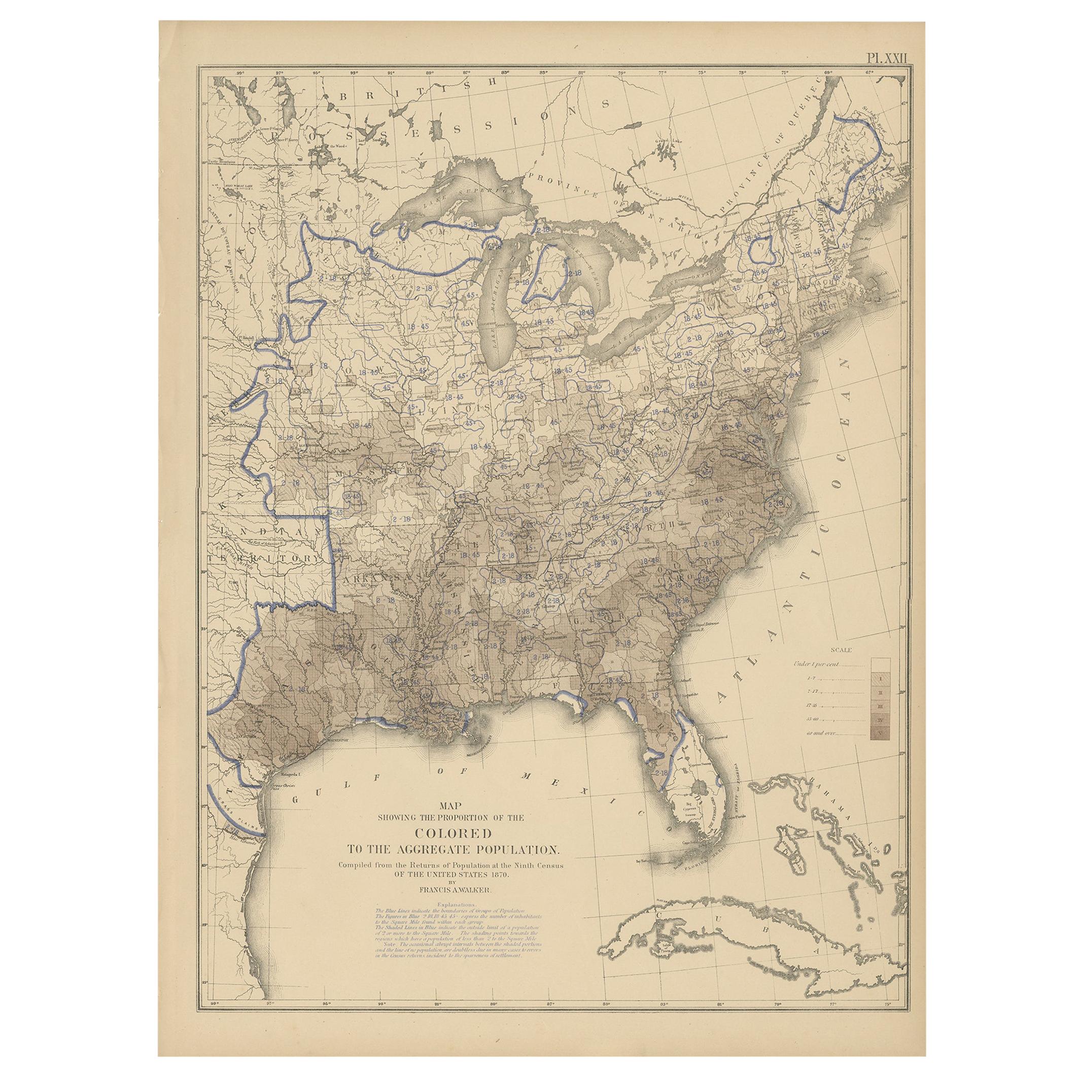
Pl. 22 Antique Chart of the US Colored Population Proportion in 1870, '1874'
Located in Langweer, NL
Antique chart titled 'Map showing the proportion of the colored to the aggregate population. Compiled from the returns of population at the ninth census of the United States, 1870'. ...
Category
Antique Late 19th Century Maps
Materials
Paper
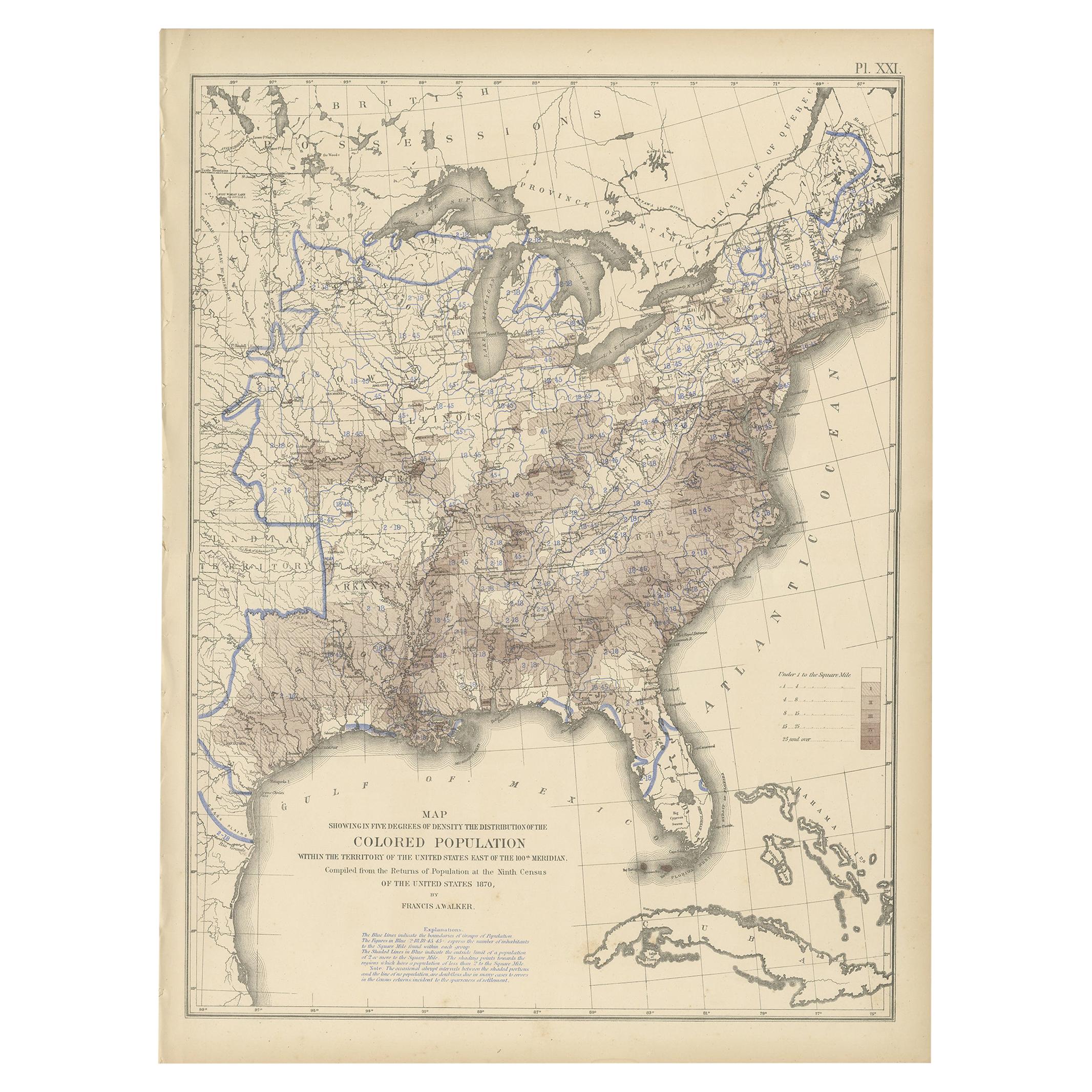
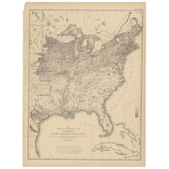
Pl. 21 Antique Chart of the US Colored Population Density in 1870, '1874'
Located in Langweer, NL
Antique chart titled 'Map showing in five degrees of density the distribution of the colored population within the territory of the United States east of the 100th Meridian. Compiled...
Category
Antique Late 19th Century Maps
Materials
Paper
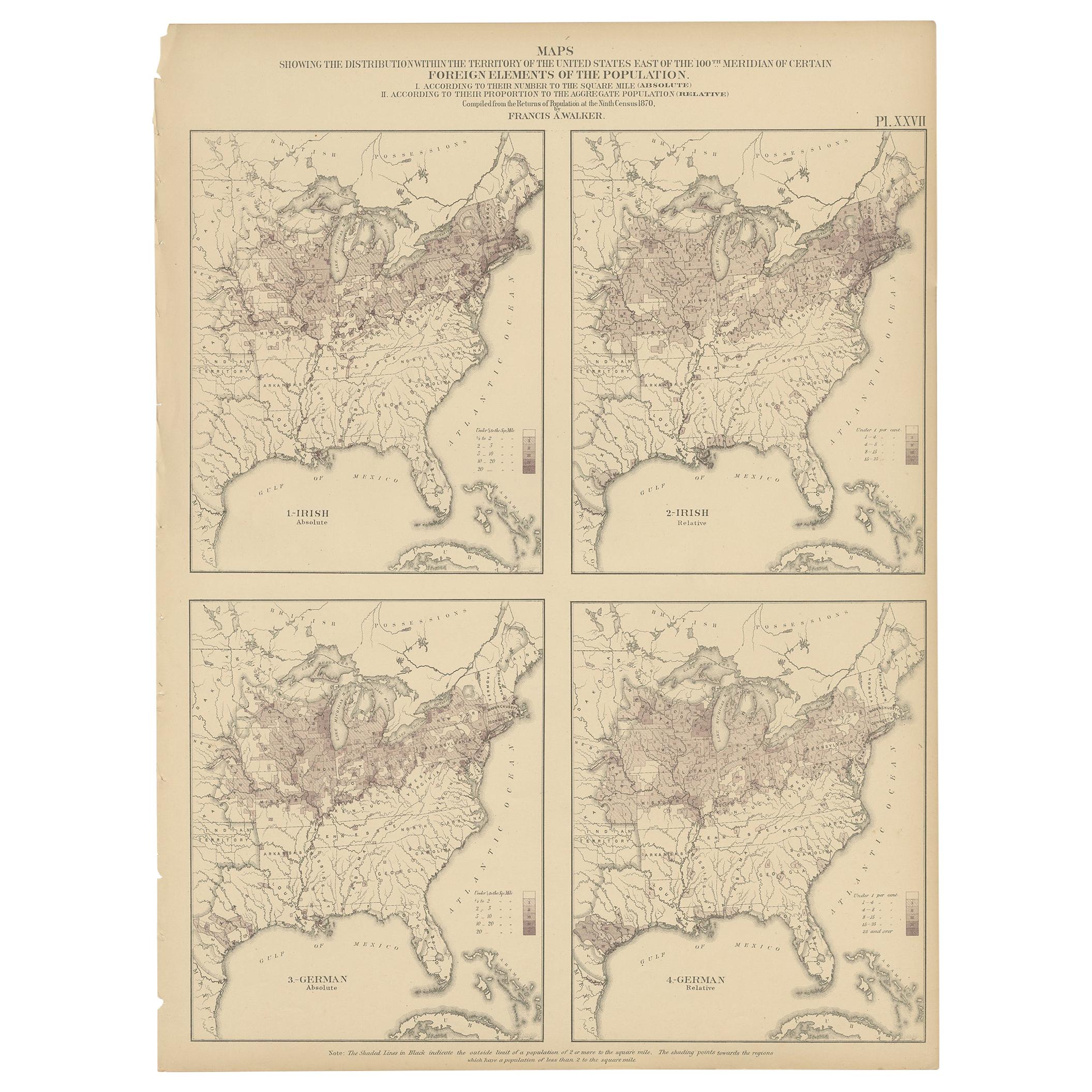
Pl. 27 Antique Chart of the US Irish and German Population in 1870, '1874'
Located in Langweer, NL
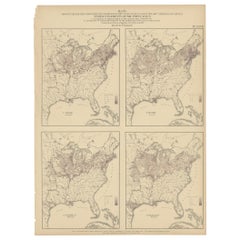
Antique chart titled 'Maps showing the distribution, within the territory of the United States, east of the 100th Meridian, of certain foreign elements of the population. I. accordin...
Category
Antique Late 19th Century Maps
Materials
Paper
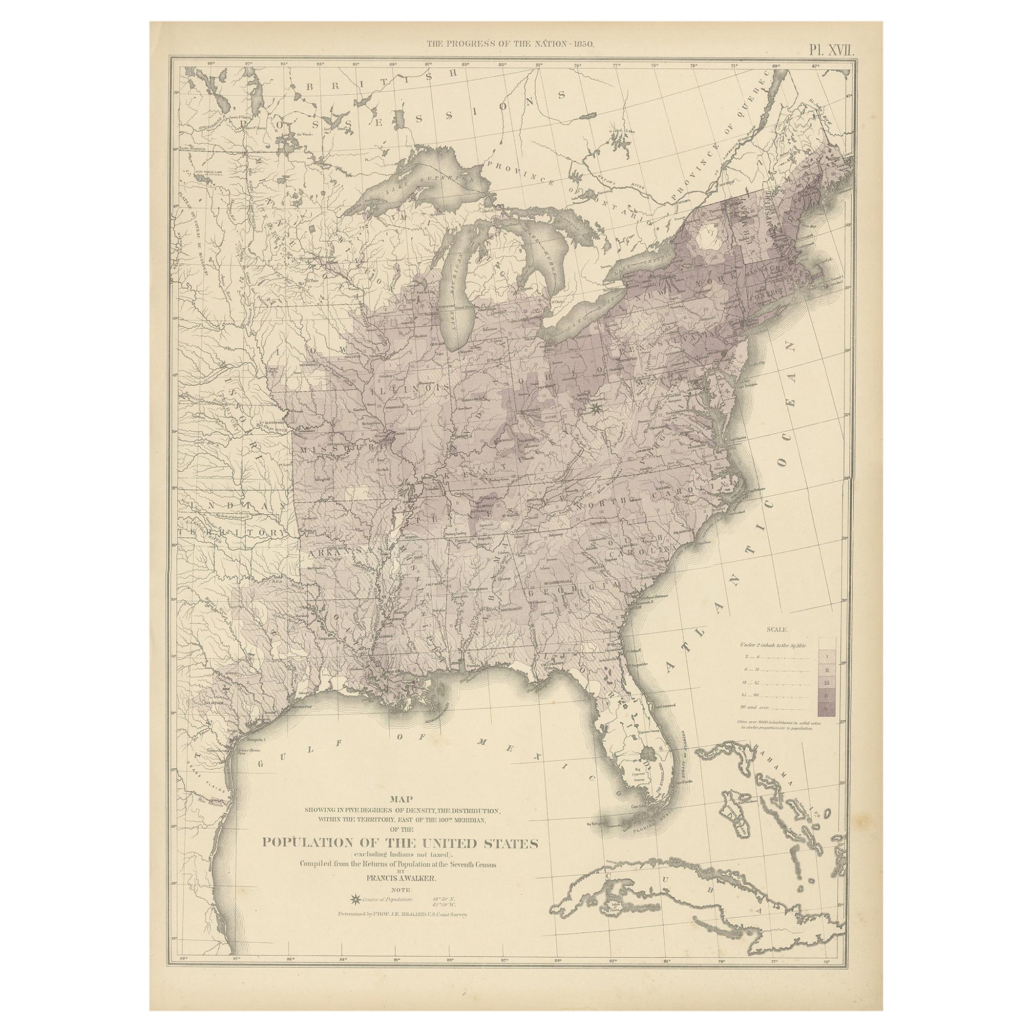
Pl. 17 Antique Chart of the US Population 1850 by Walker, 1874
Located in Langweer, NL
Antique chart titled 'Map showing in five degrees of density, the distribution, within the territory east of the 100th Meridian, of the population of the United States, excluding Ind...
Category
Antique Late 19th Century Maps
Materials
Paper
You May Also Like
Antique Anatomical Wall Chart Depicting the Human Skeleton
Located in Berghuelen, DE
A rare 19th century anatomical wall chart depicting the human skeleton. On the sides On the sides are detailed description in German language. The wall...
Category
Early 20th Century German Victorian Prints
Materials
Paper

Antique Foldable Anatomical Wall Chart Depicting Human Musculature
Located in Berghuelen, DE
Antique Foldable Anatomical Wall Chart Depicting Human Musculature
The rare 19th century anatomical wall chart depicts the human musculature and inter...
Category
Early 20th Century German Victorian Prints
Materials
Wood, Paper

Anatomical Wall Chart Depicting the Human Lymphatic and Blood Vessels
Located in Berghuelen, DE
A rare 19-carat anatomical wall chart depicting the human lymphatic and blood vessels. On the sides with detailed description in German language. Print...
Category
Early 20th Century German Victorian Prints
Materials
Paper

Genito-Urinary Anatomical Chart Fritz Frohse
By Fritz Frohse, Nystrom / Frohse Art
Located in Philadelphia, PA
Genito-Urinary Anatomical Chart by Fritz Frohse. Dated 1922. Paper mounted on canvas. Shows wear but still presents very well!
Category
Vintage 1920s German American Classical Prints
Materials
Canvas, Paper

Foldable Anatomical Wall Chart Depicting Human Musculature
Located in Berghuelen, DE
Foldable Anatomical Wall Chart Depicting Human Musculature
A rare 19th century anatomical wall chart depicting human musculature and internal organs. ...
Category
Early 20th Century German Victorian Prints
Materials
Paper

Antique 18th Century Map of the Province of Pensilvania 'Pennsylvania State'
Located in Philadelphia, PA
A fine antique of the colony of Pennsylvania.
Noted at the top of the sheet as a 'Map of the province of Pensilvania'.
This undated and anonymous map is thought to be from the Gentleman's Magazine, London, circa 1775, although the general appearance could date it to the 1760's.
The southern boundary reflects the Mason-Dixon survey (1768), the western boundary is placed just west of Pittsburgh, and the northern boundary is not marked.
The map has a number of reference points that likely refer to companion text and appear to be connected to boundaries. The western and southern boundaries are marked Q, R, S, for example. A diagonal line runs from the Susquehanna R to the Lake Erie P. A broken line marked by many letters A, B, N, O, etc., appears in the east.
There are no latitude or longitude markings, blank verso.
Framed in a shaped contemporary gilt wooden frame and matted under a cream colored matte.
Bearing an old Graham Arader Gallery...
Category
Antique 18th Century British American Colonial Maps
Materials
Paper

Recently Viewed
View AllMore Ways To Browse
Arnold And Son
Original Antique Map Of Ireland
Sailing Charts
1820 World Map
Antique Civil War Maps
Antique Map Of Jerusalem
Lowry Map
Portuguese Coat Of Arms
Antique Celestial Maps
Antique Marine Compass
Cyprus Antique Maps
John Speed Maps
Kingdom Of Ireland Maps
Map Of Champagne
Bengal Map
Map Of Jerusalem
Croatian Antiques
Afghanistan Map