Items Similar to Ancient Gaul: A Cartographic Overview of Gallic Tribes and Roman Provinces, 1880

Want more images or videos?
Request additional images or videos from the seller
1 of 9
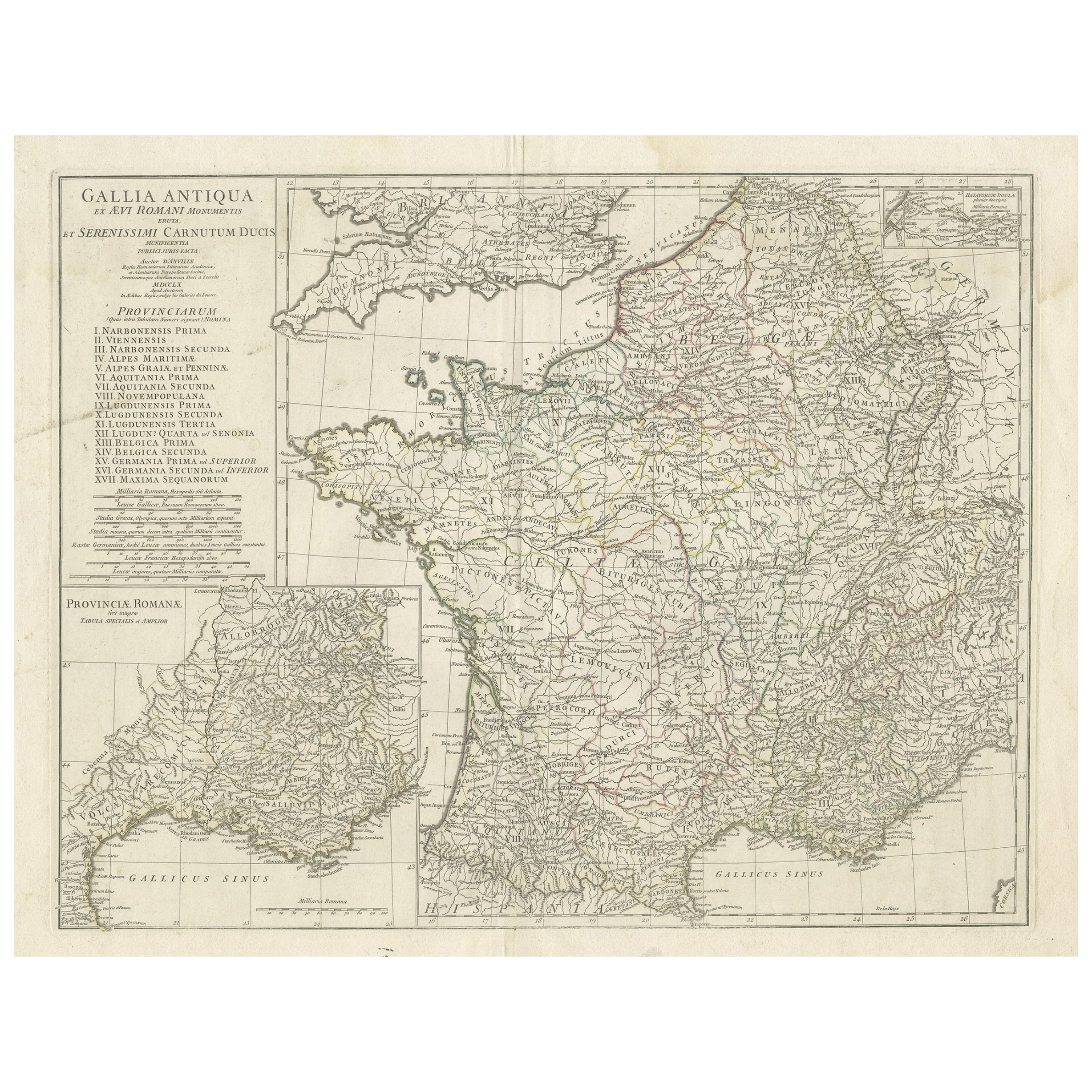
Ancient Gaul: A Cartographic Overview of Gallic Tribes and Roman Provinces, 1880
About the Item
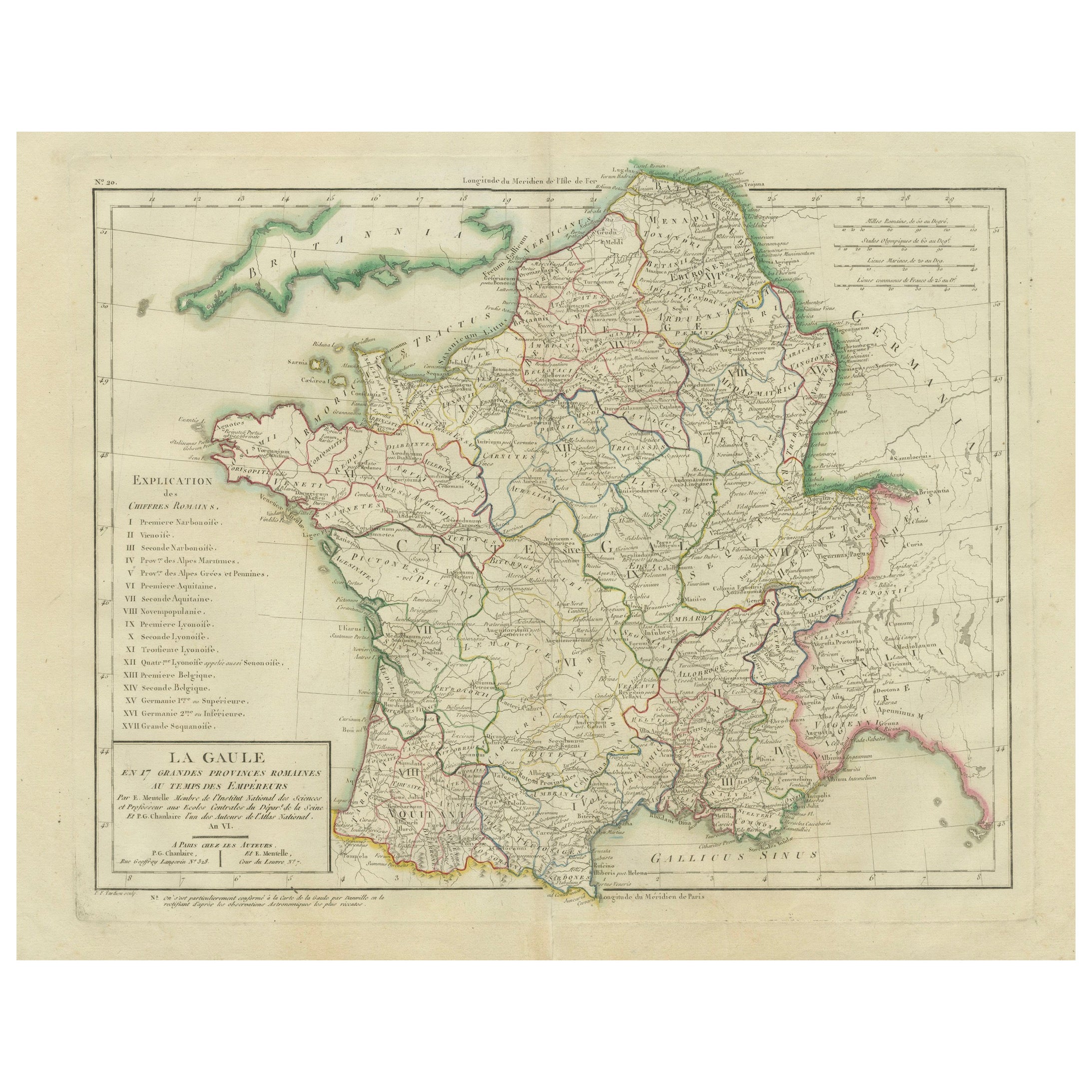
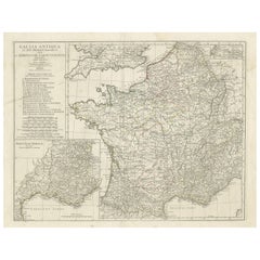
The print titled "GALLIA," is a historical map of ancient Gaul, which corresponds to modern-day France and parts of its surrounding countries. Here are the features and details noted in the print:
1. **Regional Divisions**: The map is color-coded to delineate the various tribes or administrative divisions within Gaul during ancient times. The regions are probably labeled with the names they were known by during the Roman era.
2. **Topography**: It shows detailed physical features such as mountain ranges, including the Alps (notably marked as "ALPES COTTIAE, MARITIMAE, NARBONENSIS V. VIENNENSIS"), river systems like the Rhine and Rhône, and other geographic features of the landscape.
3. **Inset Maps**: The map includes inset maps focusing on specific areas:
- The top left inset is labeled "INSULA BATAVORUM," which likely depicts the Batavian Island area near the Rhine, inhabited by the Batavi tribe.
- The bottom left inset shows a detailed map of the alpine regions, possibly providing a closer look at the topography and settlements in these areas during Roman times.
4. **Cities and Settlements**: Symbols and labels indicate the locations of important cities, towns, and possibly Roman outposts or colonies. These locations may include significant Gallic settlements and Roman cities such as Lugdunum (Lyon) and Lutetia (Paris).
5. **Road Networks**: Lines may represent the Roman road network, which facilitated military, trade, and administrative connectivity across the vast province.
6. **Latin Labels**: Names and descriptions are provided in Latin, which was the lingua franca of the Roman Empire and commonly used in academic works of the 19th century.
7. **Bordering Territories**: The map also shows the adjacent regions and territories at the time, which could include parts of the Roman provinces Germania, Belgica, and others.
8. **Legend and Scale**: A legend is present, explaining the symbols and color codes used throughout the map, along with a scale for distance measurement.
This map would be an invaluable tool for historical and educational purposes, offering a snapshot of the geographical and political landscape of ancient Gaul during the Roman era. It is a testament to the cartographic and historical knowledge of the 19th century, reflecting the scholarly efforts to understand and visualize the past.
This map is intriguing for several reasons:
1. **Historical Coverage**: It represents ancient Gaul, a region that was crucial in the history of the Roman Empire and the subsequent formation of Europe. It provides a visual representation of the Roman province before the fall of the Roman Empire.
2. **Rich Detail**: The map includes detailed depictions of geographical features, settlements, and the extensive network of Roman roads, showcasing the advanced state of Roman surveying and infrastructure.
3. **Cultural Significance**: Gaul was the site of significant historical events, including the Gallic Wars led by Julius Caesar and the later cultural and political developments that laid the groundwork for the medieval kingdoms of Europe.
4. **Roman Influence**: The map illustrates the extent of Roman influence in Gaul, including the spread of Roman towns and the Romanization of indigenous Celtic tribes.
5. **Linguistic Heritage**: The use of Latin nomenclature reflects the linguistic heritage left by the Romans, many of which influence modern French and other Romance languages.
6. **Inset Maps**: The additional detailed maps of specific areas, such as the Batavian Island and the Alpine regions, offer a closer look at these important sub-regions within Gaul.
7. **Educational Value**: For historians, scholars, and enthusiasts of ancient history, this map serves as an educational resource for understanding the complexities of ancient Gaul and its integration into the Roman Empire.
The period depicted on the map is likely to be during the Roman occupation of Gaul, which lasted from the 1st century BC, following the Gallic Wars, until the fall of the Western Roman Empire in the 5th century AD. The precise period could be more specifically identified by analyzing the names of the tribes, the designation of the Roman provinces, and the status of the road networks shown on the map.
- Dimensions:Height: 15.56 in (39.5 cm)Width: 18.51 in (47 cm)Depth: 0 in (0.02 mm)
- Materials and Techniques:
- Period:
- Date of Manufacture:1880
- Condition:Good, given age. General age-related toning, especially around the edges. Vertical folding line as issued. Please study scan carefully.
- Seller Location:Langweer, NL
- Reference Number:Seller: BG-13686-2-111stDibs: LU3054338540252
About the Seller
5.0
Recognized Seller
These prestigious sellers are industry leaders and represent the highest echelon for item quality and design.
Platinum Seller
Premium sellers with a 4.7+ rating and 24-hour response times
Established in 2009
1stDibs seller since 2017
2,412 sales on 1stDibs
Typical response time: 1 hour
- ShippingRetrieving quote...Shipping from: Langweer, Netherlands
- Return Policy
Authenticity Guarantee
In the unlikely event there’s an issue with an item’s authenticity, contact us within 1 year for a full refund. DetailsMoney-Back Guarantee
If your item is not as described, is damaged in transit, or does not arrive, contact us within 7 days for a full refund. Details24-Hour Cancellation
You have a 24-hour grace period in which to reconsider your purchase, with no questions asked.Vetted Professional Sellers
Our world-class sellers must adhere to strict standards for service and quality, maintaining the integrity of our listings.Price-Match Guarantee
If you find that a seller listed the same item for a lower price elsewhere, we’ll match it.Trusted Global Delivery
Our best-in-class carrier network provides specialized shipping options worldwide, including custom delivery.More From This Seller
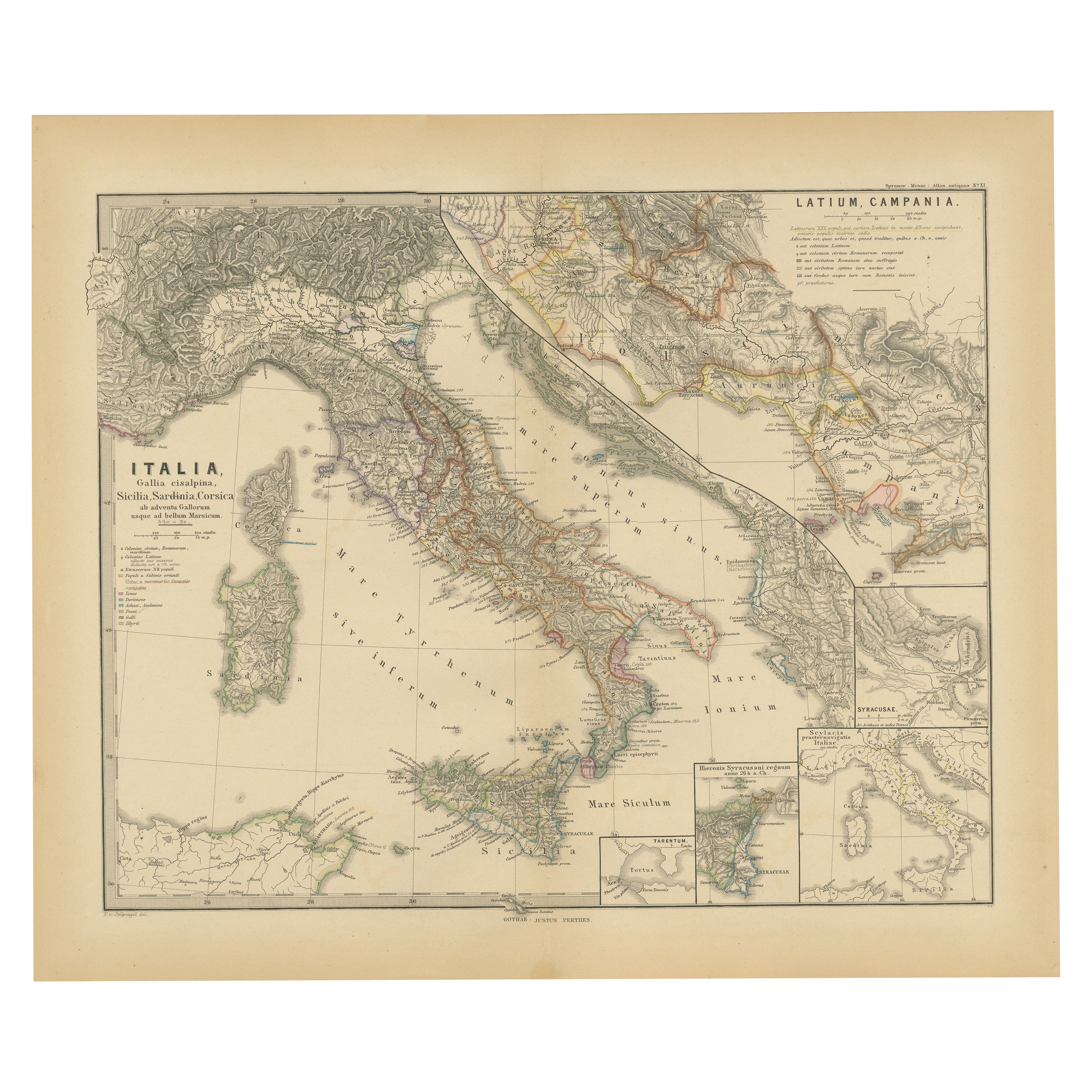
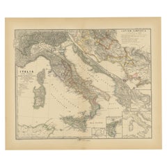
View AllRoman Italy and Provinces: A Cartographic Snapshot, 1880
Located in Langweer, NL
The map titled "ITALIA, Gallia Cisalpina, Sicilia, Sardinia, Corsica" focuses on Italy and its surrounding regions during Roman times. It offers a detailed depiction of the Italian peninsula, the Po Valley (Gallia Cisalpina), and the islands of Sicily, Sardinia, and Corsica.
Produced as part of the "Spruner-Menke Atlas Antiquus" by Karl Spruner von Merz and edited by Theodorus Menke, this map reflects the 19th-century European scholarship on ancient geography and history.
The period represented is likely during the Roman Republic or early Roman Empire, suggested by the level of detail in regions like Latium and Campania, which were central to Roman culture and power. This era was marked by Roman expansion and consolidation of the Italian peninsula, as well as the Punic Wars, which led to Roman dominance over the Mediterranean.
What makes this map interesting is its:
1. **Rich Detail**: The map delineates the intricate network of Roman roads, cities, and colonies, showing the infrastructure that facilitated Roman administration and control.
2. **Strategic Locations**: It identifies strategic locations like harbors and passes, crucial for trade and military campaigns.
3. **Geographic Accuracy**: It reflects the geographical knowledge of the time, with an accurate representation of the topography that shaped the development of these regions.
4. **Cultural and Historical Sites**: Insets of important sites like Syracuse offer a closer look at places of historical significance.
5. **Educational Purpose**: The map was designed to aid in the study of Roman history, providing a visual tool for understanding the ancient world...
Category
Antique 1880s Maps
Materials
Paper
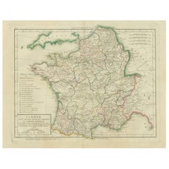
Map of Ancient Gaul & Roman Provinces: Early 19th Century - 1802 Tardieu Atlas
Located in Langweer, NL
### Antique Map Description
**Title:** La Gaule et Ses Grandes Dignités Romaines au Temps des Empereurs
**Publication Details:**
- **Atlas Title:** Nouvel Atlas Universel de Géogra...
Category
Antique Early 1800s Maps
Materials
Paper
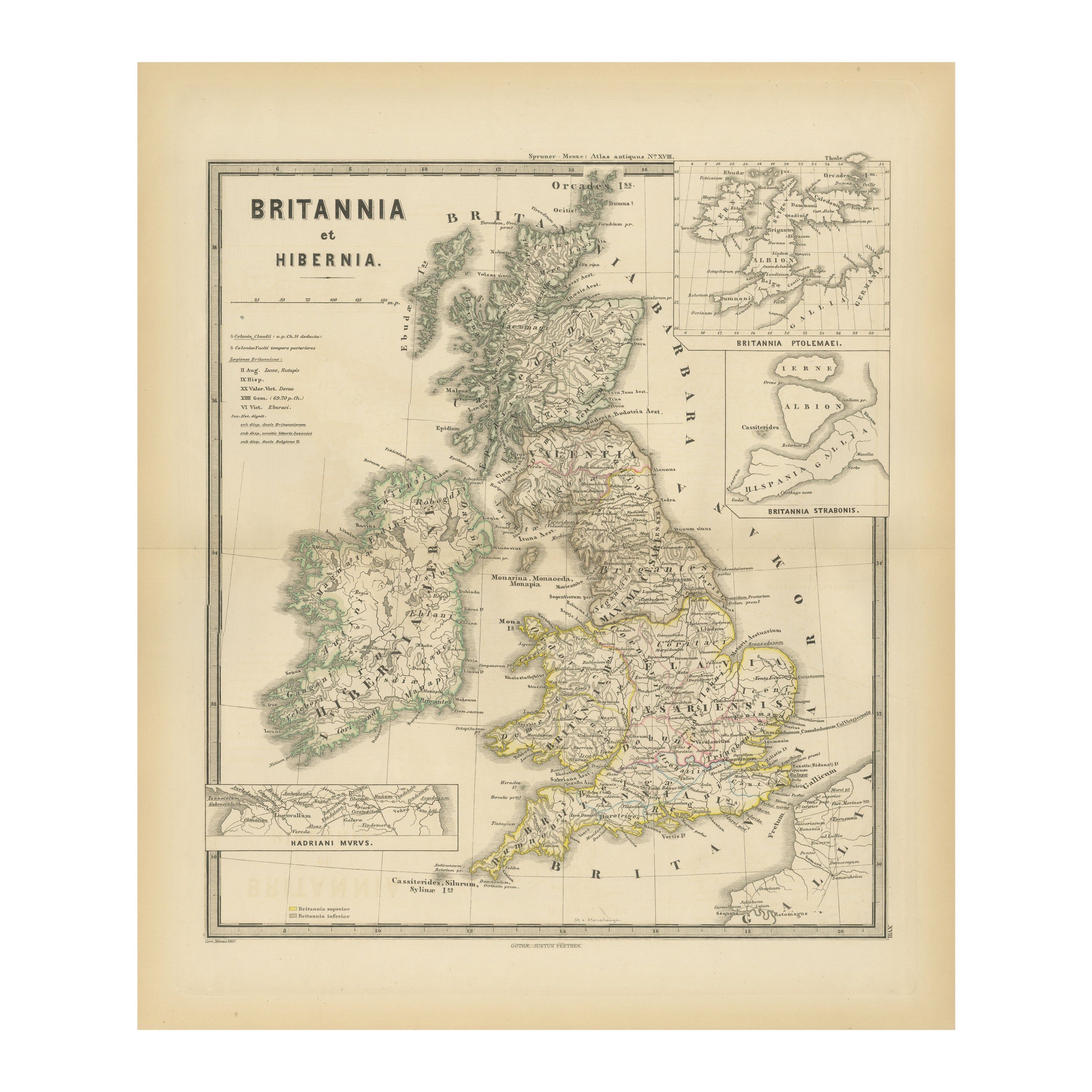
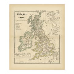
Ancient Cartography of Britannia and Hibernia, Published in 1880
Located in Langweer, NL
This map depicts the geographical area of Great Britain and Ireland, labeled "BRITANNIA et HIBERNIA." It is a historical map, as indicated by the Latin titles and the classical names of regions and tribes.
In the main section of the map, Great Britain is depicted in fine detail, with topographical features such as mountains and rivers. The map is color-coded, to differentiate political or tribal boundaries. Various Roman place names are indicated, such as "Londinium" for London.
To the left of Great Britain is Ireland, referred to as "Hibernia," similarly detailed with its own topographical features and ancient...
Category
Antique 1880s Maps
Materials
Paper
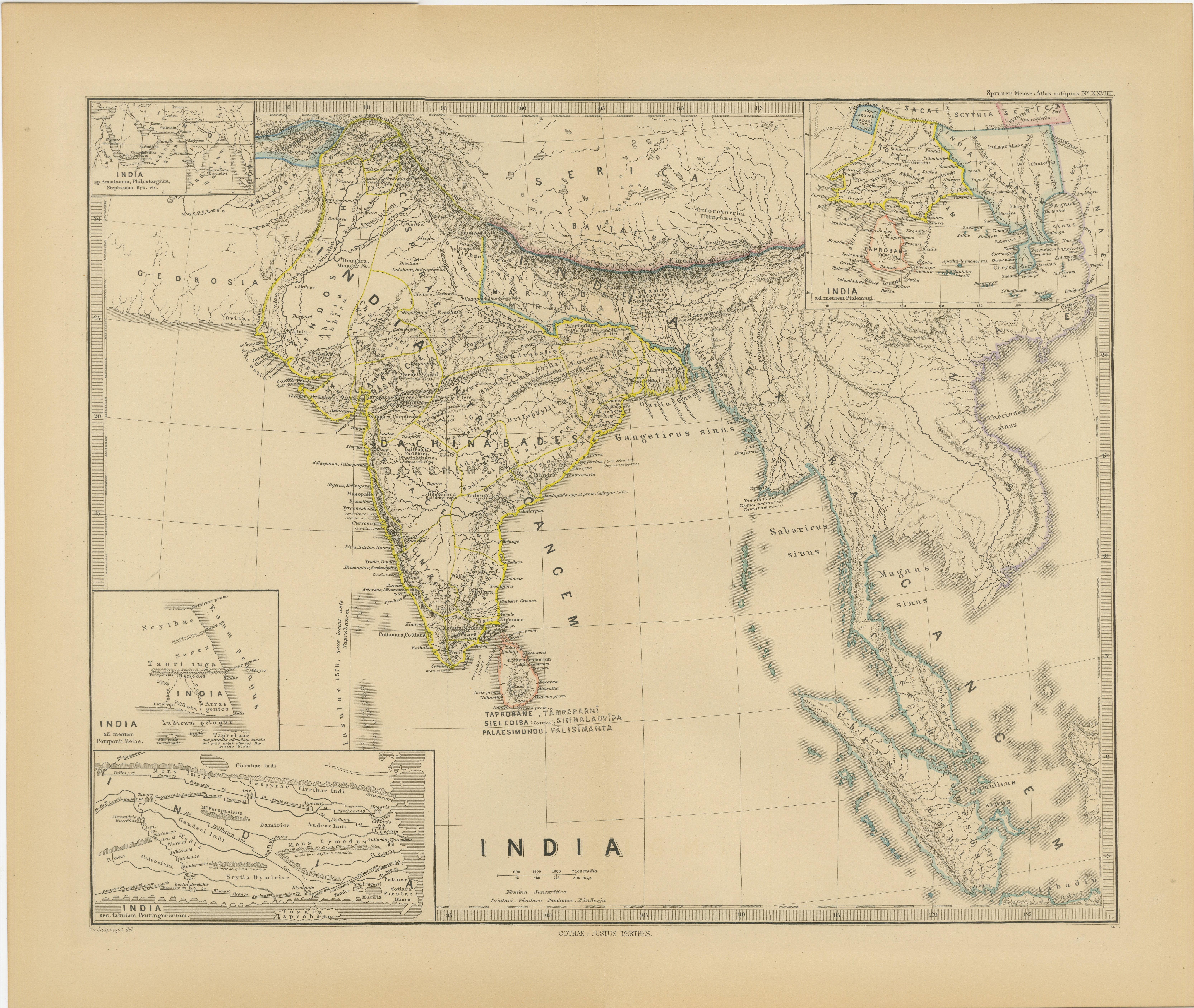
Ancient Cartography of the Indian Subcontinent, Published in 1880
Located in Langweer, NL
This map is titled "INDIA," and it provides a detailed view of the Indian subcontinent with various inset maps that offer additional historical and geographical context.
The main ma...
Category
Antique 1880s Maps
Materials
Paper

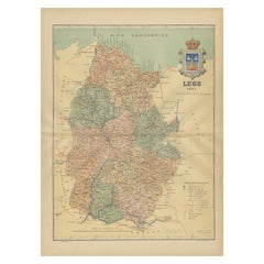
Lugo 1901: A Cartographic Chronicle of Galicia's Ancient Roman Walled City
Located in Langweer, NL
The map presents the province of Lugo, located in the autonomous community of Galicia in northwestern Spain, as it was in 1901. Notable features include:
- **Topography**: The provi...
Category
Antique Early 1900s Maps
Materials
Paper
Large Antique Map of Gaul, or France in Ancient Roman Times
Located in Langweer, NL
Original antique map titled 'Gallia Antiqua ex Aevi Romani Monumentis (..)'. Large map of Gaul, or France in ancient Roman times, showing Roman provinces. Inset bottom left a detaile...
Category
Antique Mid-18th Century Maps
Materials
Paper
You May Also Like
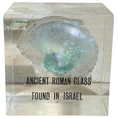
Ancient Roman Glass
Located in Delray Beach, FL
Beautiful original ancient Roman glass embedded in Lucite cube, was used for containing perfume. Exceptional object of art for display.
Category
Antique 15th Century and Earlier Israeli Glass
Materials
Murano Glass
$395 Sale Price
71% Off
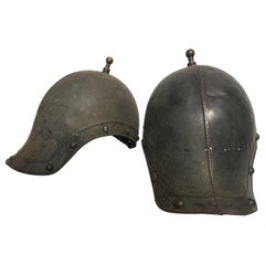
Pair of 1930s Reproduction Ancient Roman Soldiers Helmets
Located in Tarrytown, NY
Pair of 1930s metal reproduction ancient Roman soldiers helmets.
Category
Vintage 1930s Arms, Armor and Weapons
Materials
Metal
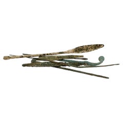
Group of Ancient Roman Bronze Tools & Hair Pins
Located in Philadelphia, PA
A fine group of ancient Roman bronze implements and artifacts.
Consisting of pins & several small scale tools.
From the private collection of Lawrence Majewski, who was a former co...
Category
Antique 15th Century and Earlier Italian Classical Roman Antiquities
Materials
Bronze
Sun and Moon a Story of Astronomy, Photography and Cartography
Located in New York, NY
A unique pictorial history of astronomical exploration from the earliest Prehistoric observatories to the latest satellite images with 280 spectacular images and an inspiring story i...
Category
21st Century and Contemporary European Books
Materials
Paper

A Collection of 4 Ancient Roman Bronze Coin 200-300 AD Collectible Object
Located in Wembley, GB
A collection of 4 nice original ancient large bronze Roman coins. Could be emperor Caracalla dating from circa.200-300 AD. Shows nice detail, imagine all the places these coins have ...
Category
Antique 15th Century and Earlier Italian Classical Roman Historical Memo...
Materials
Metal, Bronze
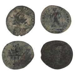
$1,301 Sale Price
20% Off
Free Shipping
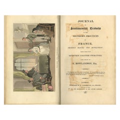
Journal of Sentimental Travels in the Southern Provinces of France – Rowlandson
Located in Middletown, NY
Combe, William (uncredited). Illustrated by Thomas Rowlandson
Journal of Sentimental Travels in the Southern Provinces of France Shortly Before the Revolution; Embellished with Seve...
Category
Antique Early 19th Century English Books
Materials
Leather, Paint, Paper
Recently Viewed
View AllMore Ways To Browse
Ancient Roman Empire
French Educational
Used Furniture Fall River
Antique Gallia
French Military Prints 19th Century
19th Century Carpet Bag
3 Piece Sterling Silver Tea Set
48 Round Coffee Table
7 Foot Sofa
Antique Cherry Chair
Antique Mason Plates
Antique Measuring Jugs
Antique Red Trunk
Antique Table 4 Drawers
Antique Work Stool
Antique Yolk
Art Nouveau Silver Overlay
Axe Table