Items Similar to 1690 Frederick de Wit Sea Chart of Hudson Bay, Baffin Bay and Greenland

Want more images or videos?
Request additional images or videos from the seller
1 of 6
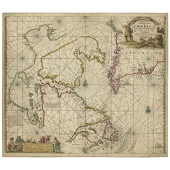
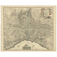
1690 Frederick de Wit Sea Chart of Hudson Bay, Baffin Bay and Greenland
About the Item
Title: c. 1690 Frederick de Wit Sea Chart of Hudson Bay, Baffin Bay, and Greenland - Engraved by Romeyn de Hooghe
This striking sea chart by Frederick de Wit, titled "Septemtrionaliora Americae à Groenlandia, per Freta Davidis et Hudson, ad Terram Novam," beautifully captures the coastlines of Hudson Bay, Baffin Bay, Davis Strait, and the surrounding parts of Canada and Greenland. Engraved by the talented Romeyn de Hooghe, this map was produced around 1690 and is based on earlier Arctic navigational maps from Jansson and Blaeu, along with information from Sanson's 1656 map. De Wit's chart was part of a significant series of Arctic maps that dominated navigation for the region throughout the late 17th century.
The map features vivid original coloring, decorative cartouches, and numerous rhumb lines that crisscross the chart, indicating the complexities of navigation in this remote part of the world. It includes depictions of ships, symbolic of maritime exploration, and a decorative title cartouche portraying explorers in a scene of adventure and discovery.
Frederick de Wit, originally from Gouda, was an influential Amsterdam-based mapmaker and publisher. His works were celebrated for their detail, accuracy, and aesthetic appeal. Following his death in 1706, much of his map collection was acquired by Pieter Mortier, whose firm eventually became part of Covens & Mortier, a significant player in 18th-century cartography.
This particular map is an excellent example of the intricate craftsmanship and geographic knowledge of the time, reflecting the rich history of exploration and the drive to chart the northernmost reaches of the American continent.
The map is in good condition, with several notable features:
- Paper Quality: The paper shows signs of age-related toning, particularly around the edges, consistent with its age. There are minor creases along the edges but no significant tears.
- Coloring: The original hand coloring remains vibrant, enhancing both the cartouches and geographical features. The colors have aged well, with minimal fading.
- Edges and Margins: The margins are intact, though there is some wear and toning along the edges. There are a few small edge tears, but they do not affect the map’s printed area.
- Folds and Creases: There are visible creases, particularly along the central fold, from the original binding. These creases are not heavily worn or significantly damaged.
- Cartouche and Details: The decorative cartouches are crisp, with clear detailing, and the rhumb lines across the map are still sharp and visible.
Summary: Overall, the map is in good condition for its age, with vibrant original coloring and clear engraving. Minor edge wear, creases, and toning are present but do not detract from the overall quality or displayability of the piece.
- Dimensions:Height: 21.07 in (53.5 cm)Width: 24.22 in (61.5 cm)Depth: 0.01 in (0.2 mm)
- Materials and Techniques:Paper,Engraved
- Period:1690-1699
- Date of Manufacture:1690
- Condition:Summary: Overall, the map is in good condition for its age, with vibrant original coloring and clear engraving. Minor edge wear, creases, and toning are present but do not detract from the overall quality or displayability of the piece.
- Seller Location:Langweer, NL
- Reference Number:Seller: BHZ113771stDibs: LU3054342590902
About the Seller
5.0
Recognized Seller
These prestigious sellers are industry leaders and represent the highest echelon for item quality and design.
Platinum Seller
Premium sellers with a 4.7+ rating and 24-hour response times
Established in 2009
1stDibs seller since 2017
2,417 sales on 1stDibs
Typical response time: <1 hour
- ShippingRetrieving quote...Shipping from: Langweer, Netherlands
- Return Policy
Authenticity Guarantee
In the unlikely event there’s an issue with an item’s authenticity, contact us within 1 year for a full refund. DetailsMoney-Back Guarantee
If your item is not as described, is damaged in transit, or does not arrive, contact us within 7 days for a full refund. Details24-Hour Cancellation
You have a 24-hour grace period in which to reconsider your purchase, with no questions asked.Vetted Professional Sellers
Our world-class sellers must adhere to strict standards for service and quality, maintaining the integrity of our listings.Price-Match Guarantee
If you find that a seller listed the same item for a lower price elsewhere, we’ll match it.Trusted Global Delivery
Our best-in-class carrier network provides specialized shipping options worldwide, including custom delivery.More From This Seller
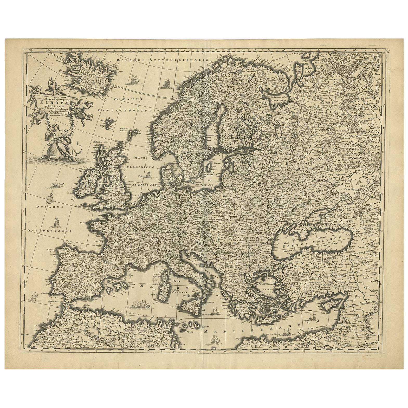
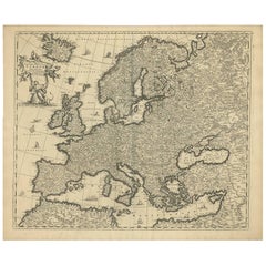
View AllGrand Map of Europe by Frederick de Wit, Circa 1690: A Baroque Era Masterpiece.
Located in Langweer, NL
This is an attractive historical map of Europe created by Frederick de Wit, published around 1690. Here's a detailed description of the map and additional context about its creation:...
Category
Antique Late 17th Century Maps
Materials
Paper
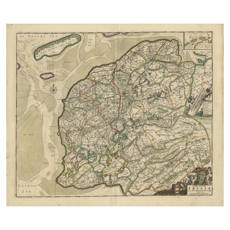
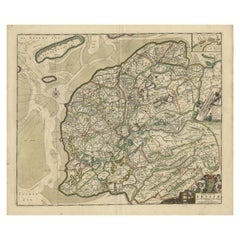
Antique Map of Friesland by De Wit, c.1690
Located in Langweer, NL
Antique map titled 'Tabula Comitatus Frisiae'.
Old map of the province of Friesland, the Netherlands. With a small inset map of the Wadden area. Third state of the map by Schotan...
Category
Antique 17th Century Maps
Materials
Paper
Antique Map of Austria by F. de Wit, 1690
Located in Langweer, NL
Antique map titled 'Circuli Austriaci pars Septentrionalis in qua Archiducatus'. Decorative and detailed map of Austria by F. de Wit.
Category
Antique Late 17th Century Maps
Materials
Paper

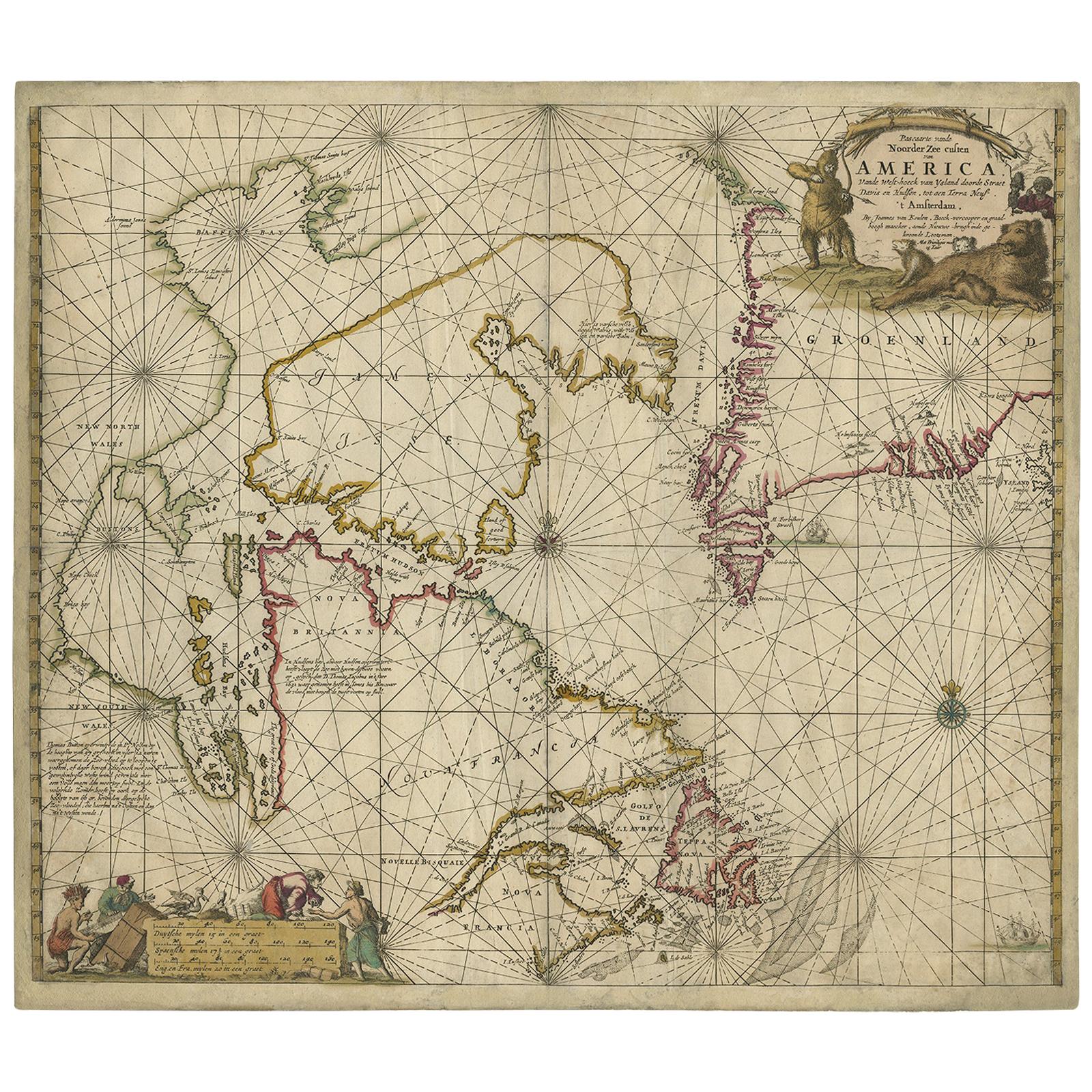
Antique Sea Chart of Hudson Bay and Arctic Canada by Van Keulen, circa 1681
Located in Langweer, NL
Antique map titled 'Pascaarte vande Noorderzee Custen van America (..)'. Sea chart of Hudson Bay and Arctic Canada. Compass roses, loxodromic lines, and ships decorate the oceans and...
Category
Antique Late 17th Century Maps
Materials
Paper
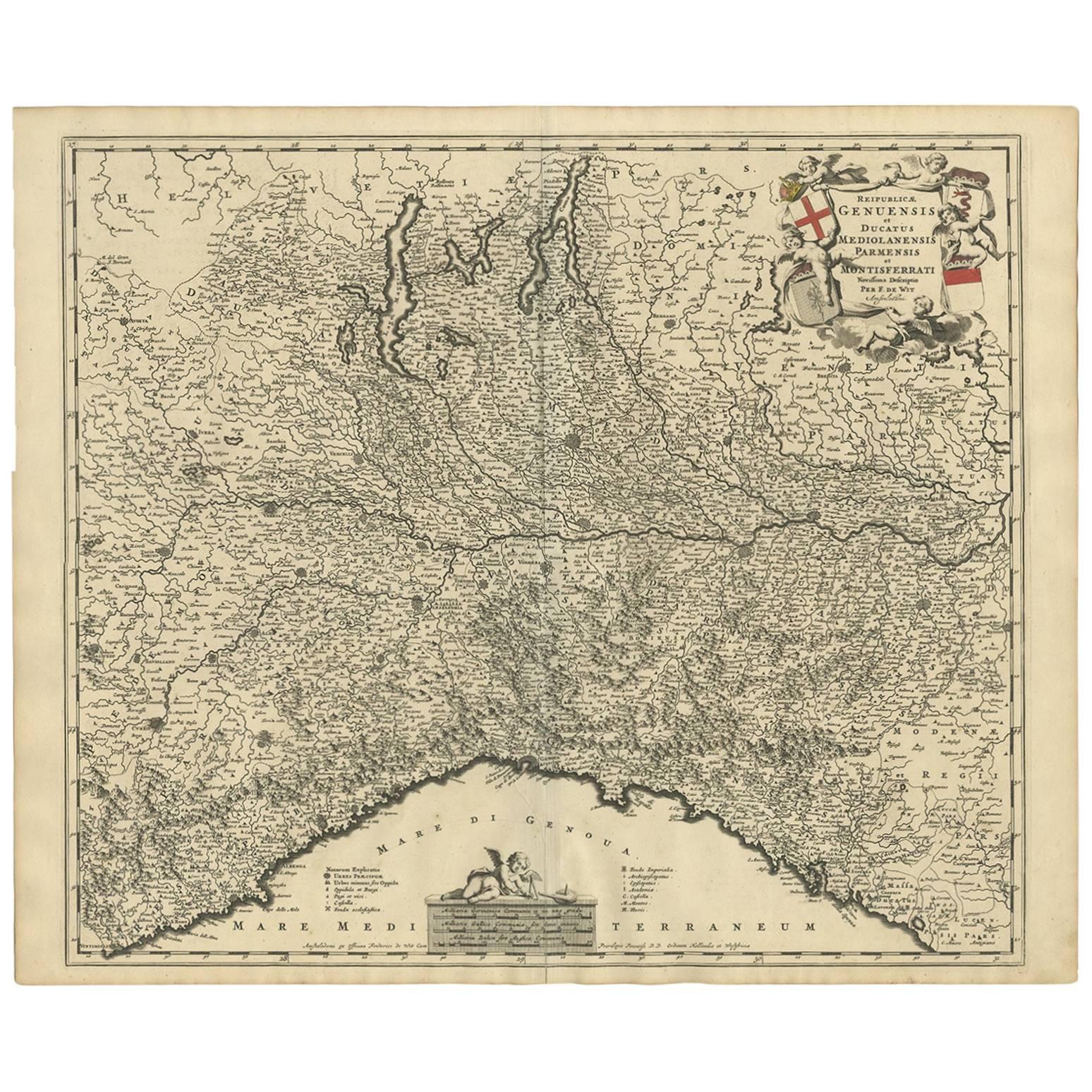
Antique Map of Northern Italy by F. de Wit, 1690
Located in Langweer, NL
A very decorative map centered on Genua, and including the towns of Milan, Torino, Parma, Cremona, etc. Decorative title cartouche upper right, five putti holding the arms of the reg...
Category
Antique Late 17th Century Maps
Materials
Paper
$510 Sale Price
20% Off
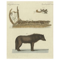
Antique Print of a Dog from Baffin Bay Greenland and a Dog Sled
Located in Langweer, NL
Antique print of a dog from Baffin Bay, located between Baffin Island and the west coast of Greenland. Top image shows a dog sled. This print originates from ...
Category
Antique Early 19th Century Prints
Materials
Paper
You May Also Like
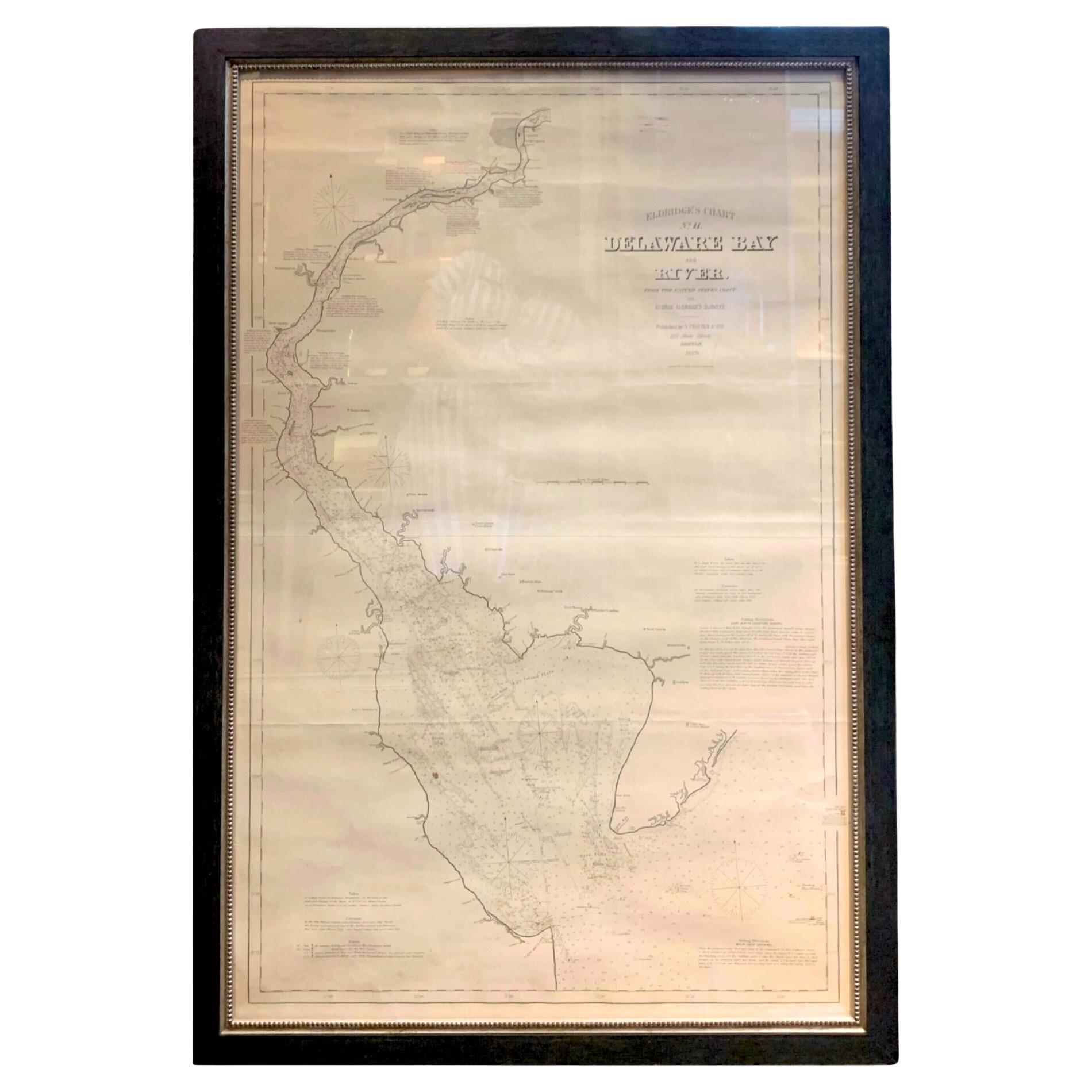
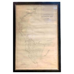
1889 Sea Chart Map of Delaware Bay by George Eldridge, Chart No. 11
Located in Colorado Springs, CO
Presented is an original Eldridge's Chart No. 11, Delaware Bay and River, from The United States Coast and George Eldridge's Surveys, published in 1889. The sea chart shows the Delaw...
Category
Antique 1880s Maps
Materials
Paper
1898 Chart of Boston Bay
Located in Norwell, MA
Original 1898 chart showing Massachusetts Bay with the coast from Cape Ann to Cape Cod. This is a U.S. Navy Geodetic survey chart. All towns are noted along the coast. Framed with gl...
Category
Antique 1890s Nautical Objects
Materials
Paper

$1,495
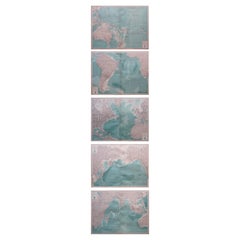
Set of 5 Large Original Vintage Sea Charts, circa 1920
Located in St Annes, Lancashire
5 great maps or charts of the oceans
I particularly like the color of these maps
Unframed
Original color
By John Bartholomew and Co. Edinburgh Geographical Institute
Published, ...
Category
Vintage 1920s British Maps
Materials
Paper
Large 17th Century Hand Colored Map of England and the British Isles by de Wit
By Frederick de Wit
Located in Alamo, CA
A large hand colored 17th century map of England and the British Isles by Frederick de Wit entitled "Accuratissima Angliæ Regni et Walliæ Principatus", published in Amsterdam in 1680. It is a highly detailed map of England, Scotland, the Scottish Isles...
Category
Antique Late 17th Century Dutch Maps
Materials
Paper

1856 U.S. Coast Survey Map of Chesapeake Bay and Delaware Bay
Located in Colorado Springs, CO
Presented is U.S. Coast Survey nautical chart or maritime map of Chesapeake Bay and Delaware Bay from 1856. The map depicts the region from Susquehanna, Maryland to the northern Outer Banks in North Carolina. It also shows from Richmond and Petersburg, Virginia to the Atlantic Ocean. The map is highly detailed with many cities and towns labeled throughout. Rivers, inlets, and bays are also labeled. Various charts illustrating more specific parts of the region are marked on the map using dotted lines. The lines form boxes, and the corresponding chart number and publication date are given. Extensive triangulation surveys were conducted the length of Chesapeake Bay and are illustrated here. Hampton Roads, Virginia is labeled, along with the James, York, and Rappahannock Rivers, which were all extensively surveyed.
The chart was published under the supervision of A. D. Bache, one of the most influential and prolific figures in the early history of the U.S. Coast Survey, for the 1856 Report of the Superintendent of the U.S. Coast Survey. Alexander Dallas Bache (1806-1867) was an American physicist, scientist, and surveyor. Bache served as the Superintendent of the U.S. Coast Survey from 1843 to 1865. Born in Philadelphia, Bache toured Europe and composed an important treatise on European Education. He also served as president of Philadelphia's Central High School and was a professor of natural history and chemistry at the University of Pennsylvania. Upon the death of Ferdinand Rudolph Hassler, Bache was appointed Superintendent of the United States Coast Survey.
The Office of the Coast Survey, founded in 1807 by President Thomas Jefferson and Secretary of Commerce Albert Gallatin...
Category
Antique 1850s American Maps
Materials
Paper

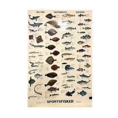
Sea Fish Saltvandsfisk Rollable Poster Print Wall Chart, Denmark 1960s
Located in Nuernberg, DE
This rare vintage wall chart shows different types of sea fish, which are native to middle Europe. This kind of wall charts are used as teaching material in German schools or diving ...
Category
Vintage 1960s German Mid-Century Modern Scientific Instruments
Materials
Aluminum
Recently Viewed
View AllMore Ways To Browse
Antique Hudson Bay
Antique Japanese Carpets
Antique Meissen Patterns
Antique Side Table With Claw Feet
Antique Silver And Glass Jewelry Box
Antique Silver Glass Jewelry Box
Antique Spiral Leg Table
Antique Table 4 Chairs
Arabia 1970
Ashtray Italy Crystal
Barber Poles
Bauhaus Plant Stand
Bench Public Furniture
Birch Dining Chairs Mid Century
Black Lacquer Wall Panels
Bright Yellow Chairs
Cantilever Leather Dining Chairs
Chinese Lacquer Cocktail Tables