Items Similar to 1616 Bertius Map of Sumatra, Singapore and the Straits of Malacca


Want more images or videos?
Request additional images or videos from the seller
1 of 8
1616 Bertius Map of Sumatra, Singapore and the Straits of Malacca
About the Item
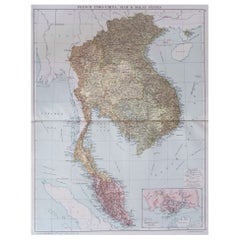
Title: "1616 Bertius Map of Sumatra and the Straits of Malacca"
Description: This is an exquisite 1616 original antique map by Petrus Bertius, titled "Sumatra Insula," showcasing Sumatra and the southern tip of Malaysia, with a unique early depiction of Singapore as 'Sinca: pura'. Oriented with north to the right, it stands as one of the earliest detailed maps emphasizing the Straits of Malacca. The map, never folded, is in very good condition, with light age-related browning at the margins and attractive old-time coloring. Latin text on the reverse side adds to its historical allure, making it a remarkable piece for collectors.
Petrus Bertius was a Flemish philosopher, theologian, historian, geographer, and cartographer, known for his work in mathematics, historical, and theological areas. He published an edition of Ptolemy's "Geographia" and is recognized for his contributions to cartography. Bertius was born in 1565 in Flanders and fled to London with his family for religious reasons, later studying at the University of Leiden. He had a significant academic career but eventually moved to France, where he became the cosmographer to Louis XIII and converted to Catholicism. He passed away in Paris in 1629.
- Dimensions:Height: 4.73 in (12 cm)Width: 7.49 in (19 cm)Depth: 0 in (0.02 mm)
- Materials and Techniques:Paper,Engraved
- Period:Early 17th Century
- Date of Manufacture:1616
- Condition:The map, never folded, is in very good condition, with light age-related browning at the margins and attractive old-time coloring. Latin text on the reverse. Study the images carefully.
- Seller Location:Langweer, NL
- Reference Number:Seller: BG-136311stDibs: LU3054337815972
About the Seller
5.0
Recognized Seller
These prestigious sellers are industry leaders and represent the highest echelon for item quality and design.
Platinum Seller
Premium sellers with a 4.7+ rating and 24-hour response times
Established in 2009
1stDibs seller since 2017
2,419 sales on 1stDibs
Typical response time: <1 hour
- ShippingRetrieving quote...Shipping from: Langweer, Netherlands
- Return Policy
Authenticity Guarantee
In the unlikely event there’s an issue with an item’s authenticity, contact us within 1 year for a full refund. DetailsMoney-Back Guarantee
If your item is not as described, is damaged in transit, or does not arrive, contact us within 7 days for a full refund. Details24-Hour Cancellation
You have a 24-hour grace period in which to reconsider your purchase, with no questions asked.Vetted Professional Sellers
Our world-class sellers must adhere to strict standards for service and quality, maintaining the integrity of our listings.Price-Match Guarantee
If you find that a seller listed the same item for a lower price elsewhere, we’ll match it.Trusted Global Delivery
Our best-in-class carrier network provides specialized shipping options worldwide, including custom delivery.More From This Seller
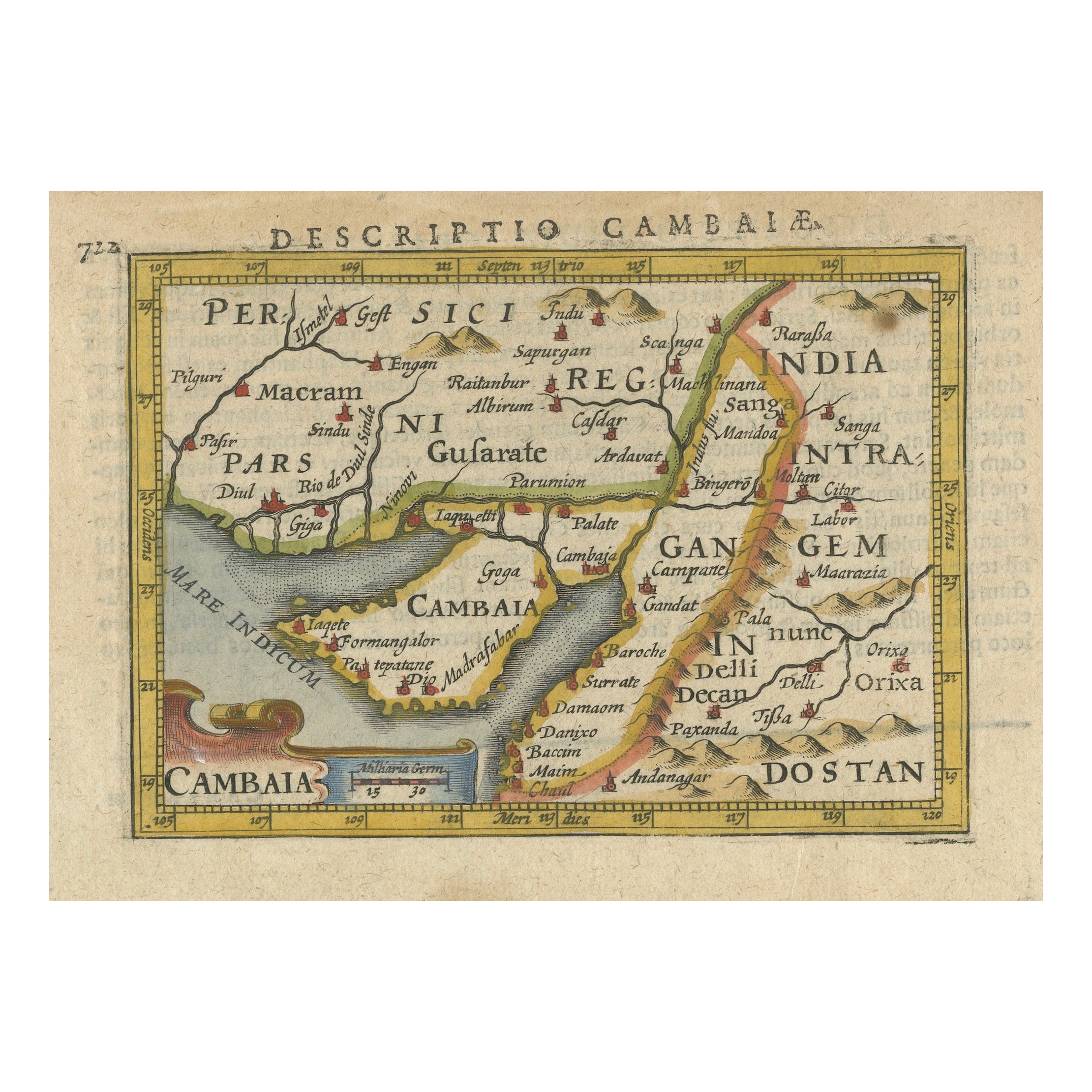
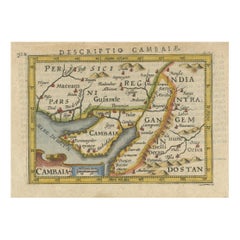
View All1616 Petrus Bertius Miniature Map of Cambay (Gujarat, India)
Located in Langweer, NL
Title: 1616 Petrus Bertius Map of Cambay and Gujarat, India
Description: This early seventeenth-century map, titled Descriptio Cambaiæ, was published in 1616 by Petrus Bertius, a ...
Category
Antique 1610s Maps
Materials
Paper
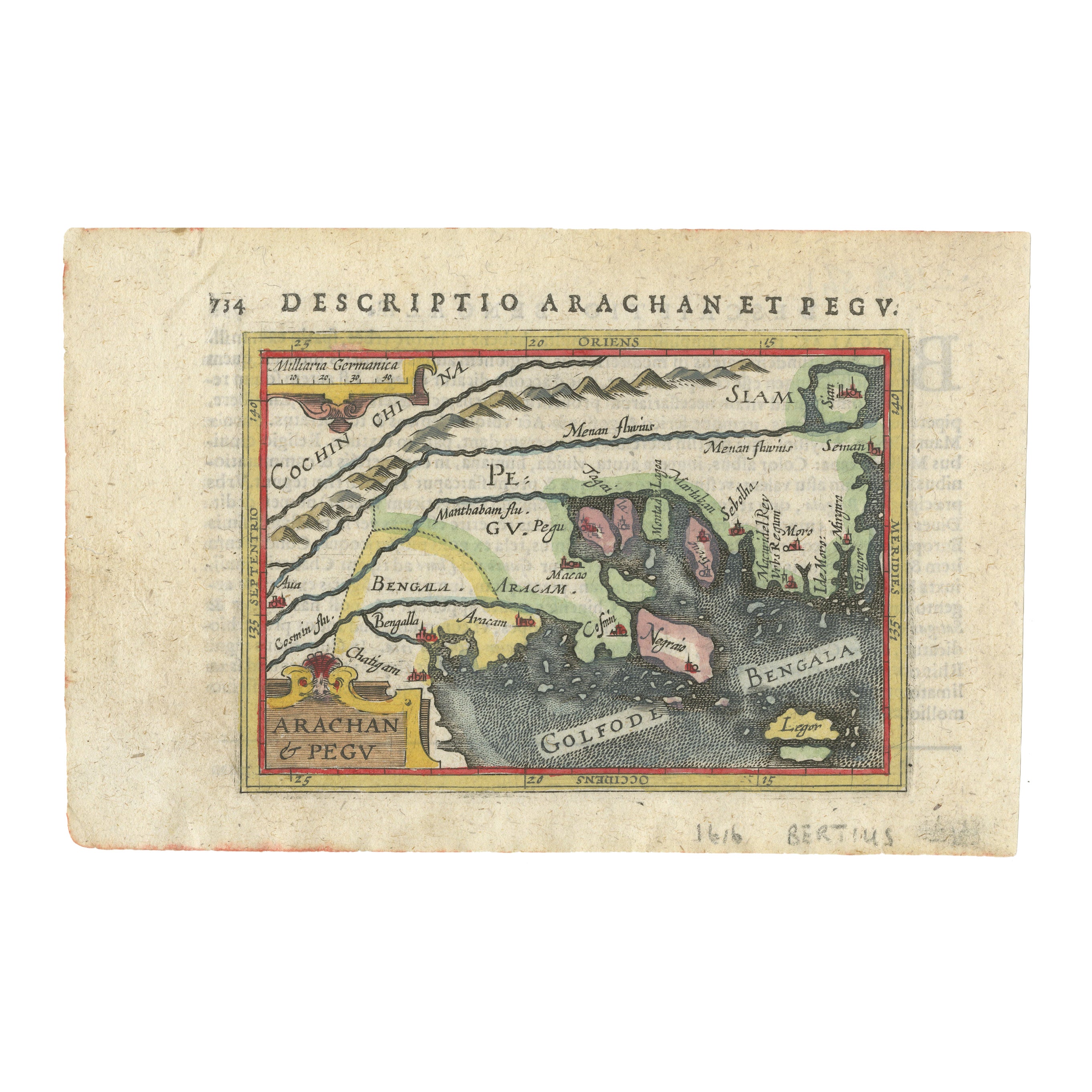
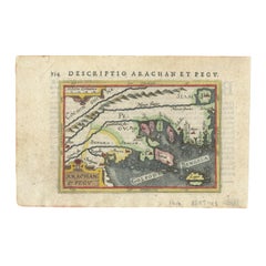
1616 Petrus Bertius Map of Arakan and Pegu in Southeast Asia
Located in Langweer, NL
Title: 1616 Petrus Bertius Map of Arakan and Pegu in Southeast Asia
Description: This early seventeenth-century map, titled Descriptio Arachan et Pegu, was published in 1616 by P...
Category
Antique 1610s Maps
Materials
Paper
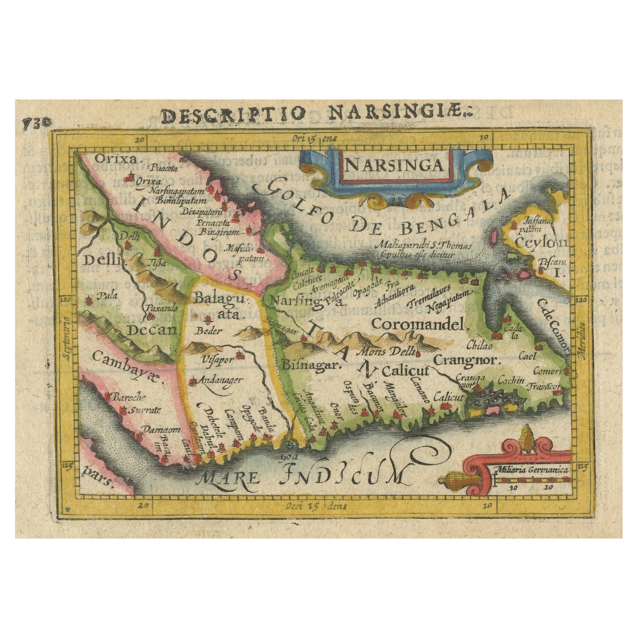
Colorful and Decorative Miniature Map of India, Ceylon by Bertius 1616
Located in Langweer, NL
Old 17th century miniature antique map of India - Ceylon from the 1616 edition of Jadocus Hondius Atlas by Petrus Bertius. Original copperplate engraving with hand coloring.
Carto...
Category
Antique 17th Century Maps
Materials
Paper

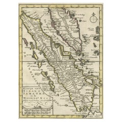
Authentic Old Map of Sumatra, Malaysia and Singapore, 1745
Located in Langweer, NL
Title: "Kaartje van't Eiland Sumatra en de Maleidse Kust gelegen na de stelling van de G. de L'Isle"
Published by Jacob Keizer and by Jan de Lat
Creator: Keizer, Jacob, active 1706...
Category
Antique 1740s Maps
Materials
Paper
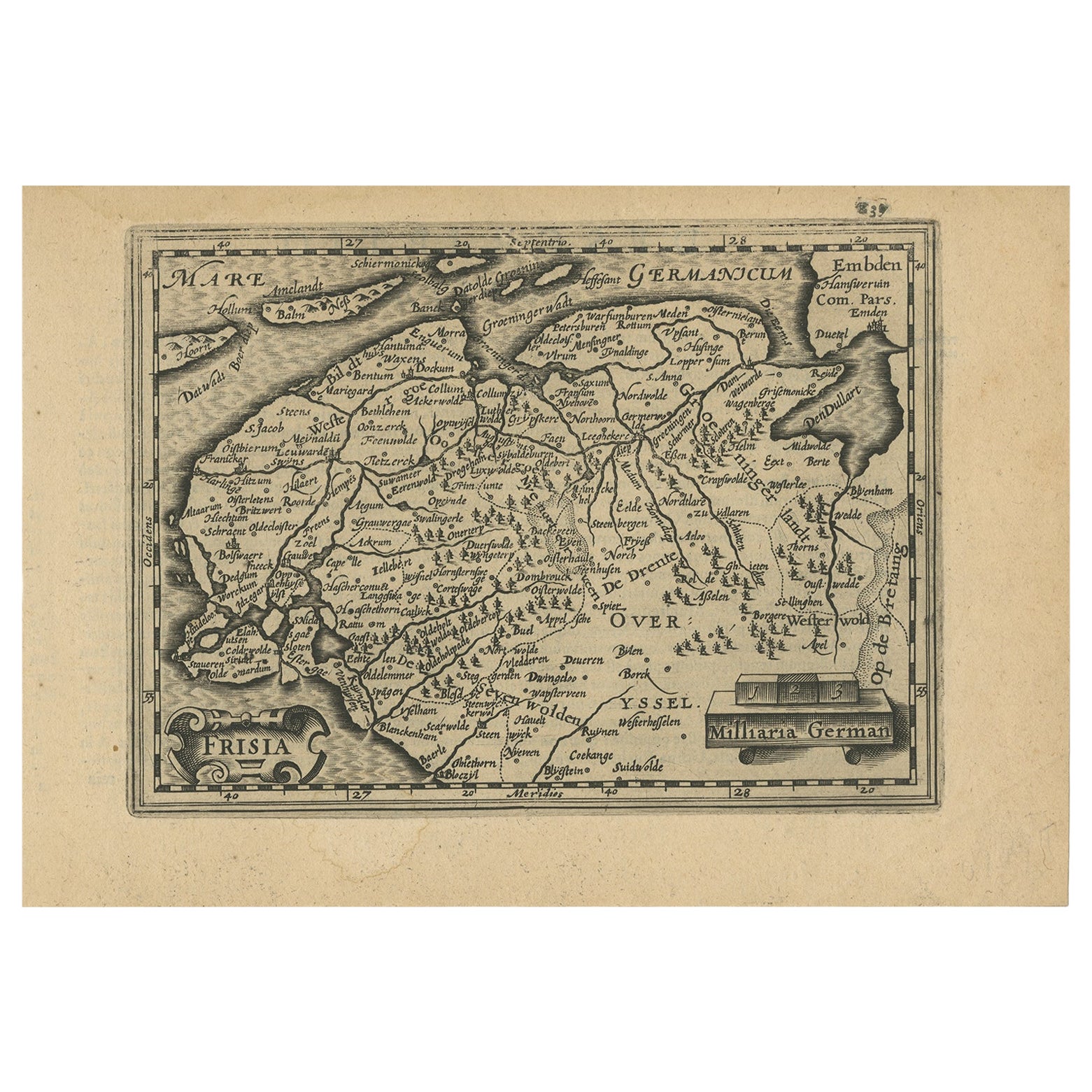
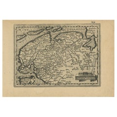
Antique Map of Friesland and Groningen in The Netherlands, 1616
Located in Langweer, NL
Antique map titled 'Frisia'. Small map of the province of Friesland, the Netherlands.
This map originates from 'Omnium Belgii, sive Inferioris Germaniae, regionum descriptio' by ...
Category
Antique 17th Century Maps
Materials
Paper
Antique Miniature Map of the Turkish Empire by Bertius '1618'
Located in Langweer, NL
Antique miniature map titled 'Turcicum Imperium'. Rare miniature map of the Turkish Empire. This map originates from 'Tabularum Geographicarum Contractarum Libri septem (..)' by P. B...
Category
Antique Early 17th Century Maps
Materials
Paper

$697 Sale Price
20% Off
You May Also Like
17th Century John Speed Map of the Barkshire Described, c.1616
By John Speed
Located in Royal Tunbridge Wells, Kent
Antique 17th century British very rare and original John Speed (1551-1629) map of the Barkshire Described, J. Sud and Georg Humble, publication (1616 or lat...
Category
Antique 17th Century British Maps
Materials
Paper

Large Original Vintage Map of S.E Asia, with a Vignette of Singapore
Located in St Annes, Lancashire
Great map of South East Asia
Original color. Good condition
Published by Alexander Gross
Unframed.
Category
Vintage 1920s English Maps
Materials
Paper
Map of the Republic of Genoa
Located in New York, NY
Framed antique hand-coloured map of the Republic of Genoa including the duchies of Mantua, Modena, and Parma.
Europe, late 18th century.
Dimension: 25...
Category
Antique Late 18th Century European Maps

Map of the Kingdom of Sardinia and Part of the Kingdom of Genoa, Rome
By Giovanni Maria Cassini
Located in Hamilton, Ontario
18th century map by Italian engraver Giovanni Maria Cassini (Italy 1745-1824). Map of Part of the Kingdom of Sardinia and Part of the Kingdom of Genoa: Rome. This is a hand colored a...
Category
Antique 18th Century Italian Maps
Materials
Paper

$795 Sale Price
36% Off
Map "Estuary- Mouth of the Thames"
Located in Alessandria, Piemonte
ST/426 - Antique French Map of the estuary of the Thames, map dated 1769 -
"Mape of the entrance of the Thames. Designed by filing of Navy cards fo...
Category
Antique Mid-18th Century French Other Prints
Materials
Paper

Colored wall map of the WORLD
By Chambon
Located in ZWIJNDRECHT, NL
“Mappe Monde, contenant les Parties Connues du Globe Terrestre”
CHAMBON, Gobert-Denis (France, 17.. - 1781)
Paris, Longchamps et Janvier, 1754
Size H. 115 x W. 145 cm.
Gobert-Denis Chambon made copper engraving after the work of Guillaume De L’Isle, published in 1754 by Jean Janvier and S.G. Longschamps.
A huge wall map of the world in two hemispheres printed on two sheets, depicting the Eastern and Western hemispheres supported by two male figures, decorated at the bottom right and left with two celestial hemispheres (boreal and southern) and at the bottom in the middle with an armillary sphere, in addition.
This map is most notable for its depiction of the Sea of Japan labeled "Mer de Corée" and of "Mer de L'Ouest" or Sea of the West - a great sea, easily the size of the Mediterranean, to flow from the then-known Strait of Juan de Fuca...
Category
Antique Mid-18th Century French French Provincial Maps
Materials
Wood, Paper

Recently Viewed
View AllMore Ways To Browse
Singapore Antique
Silver Plate Art Deco Cocktail Shaker
Small Dining Table With Extension
Square Club Chair
Sterling Condiment
Sugar Creamer Tray
Swivel Ottomans
Tavolino Coffee Table
Three Seat Leather Danish Sofa
Tooled Leather Chairs
Trestle Chair
Trophy Silver Cup
Turkish Textile Framed
Tweed Upholstery
Twist Pedestal Table
Vintage 1950s Hat
Vintage Limestone Table
Vintage Louis Vuitton Trunks