Items Similar to Antique Map of Europe by Levasseur 'c.1840'


Want more images or videos?
Request additional images or videos from the seller
1 of 6
Antique Map of Europe by Levasseur 'c.1840'
About the Item
Antique map titled 'Europe'. Original antique map of Europe. Decorative map of the continent surrounded by allegorical vignettes. Engraved by Raimond Bonheur, father of the famous French artist Rosa Bonheur. This map originates from 'Atlas National (..)' by V. Levasseur. Published circa 1840.
- Dimensions:Height: 22.64 in (57.5 cm)Width: 30.52 in (77.5 cm)Depth: 1.19 in (3 cm)
- Materials and Techniques:
- Period:
- Date of Manufacture:circa 1840
- Condition:Beautiful map with hand coloring. Frame included, good condition. Please study images carefully.
- Seller Location:Langweer, NL
- Reference Number:Seller: BG-13009-111stDibs: LU3054324193102
About the Seller
5.0
Recognized Seller
These prestigious sellers are industry leaders and represent the highest echelon for item quality and design.
Platinum Seller
Premium sellers with a 4.7+ rating and 24-hour response times
Established in 2009
1stDibs seller since 2017
2,417 sales on 1stDibs
Typical response time: <1 hour
- ShippingRetrieving quote...Shipping from: Langweer, Netherlands
- Return Policy
Authenticity Guarantee
In the unlikely event there’s an issue with an item’s authenticity, contact us within 1 year for a full refund. DetailsMoney-Back Guarantee
If your item is not as described, is damaged in transit, or does not arrive, contact us within 7 days for a full refund. Details24-Hour Cancellation
You have a 24-hour grace period in which to reconsider your purchase, with no questions asked.Vetted Professional Sellers
Our world-class sellers must adhere to strict standards for service and quality, maintaining the integrity of our listings.Price-Match Guarantee
If you find that a seller listed the same item for a lower price elsewhere, we’ll match it.Trusted Global Delivery
Our best-in-class carrier network provides specialized shipping options worldwide, including custom delivery.More From This Seller
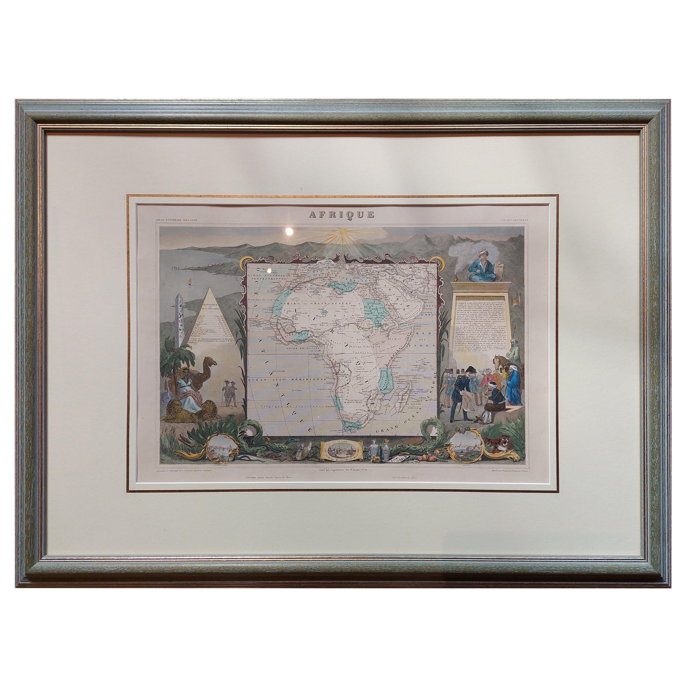
View AllAntique Map of Africa by Levasseur 'c.1840'
Located in Langweer, NL
Antique map titled 'Afrique'. Original antique map of Africa. Decorative map of the continent surrounded by allegorical vignettes. Engraved by Raimond Bonheur, father of the famous F...
Category
Antique Mid-19th Century Maps
Materials
Paper
$464 Sale Price
20% Off
Antique Map of Europe by Levasseur, '1875'
Located in Langweer, NL
Antique map titled 'Carte générale de l'Europe'. Large map of Europe. This map originates from 'Atlas de Géographie Moderne Physique et Politique' by A. Levasseur. Published 1875.
Category
Antique Late 19th Century Maps
Materials
Paper

$348 Sale Price
40% Off
Antique Map of Russia in Europe by Levasseur, '1875'
Located in Langweer, NL
Antique map titled 'Carte générale de la Russie d'Europe (..)'. Large map of Russia in Europe. This map originates from 'Atlas de Géographie Moderne Physique et Politique' by A. Leva...
Category
Antique Late 19th Century Maps
Materials
Paper

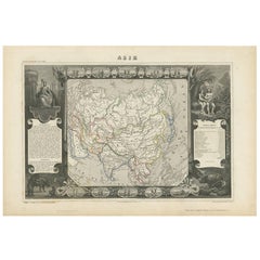
Antique Map of Asia by V. Levasseur, 1854
By Victor Levasseur
Located in Langweer, NL
Antique map titled 'Asie'. Map of the main Asian continent. The decorated border shows various images, as well as two blocks of statistical text on the continent, including populatio...
Category
Antique Mid-19th Century Maps
Materials
Paper
$191 Sale Price
40% Off
Antique Map of Brazil by Levasseur '1875'
Located in Langweer, NL
Antique map titled 'Carte du Brésil'. Large map of Brazil, with small fold out. This map originates from 'Atlas de Géographie Moderne Physique et Politiq...
Category
Antique Late 19th Century Maps
Materials
Paper
$371 Sale Price
20% Off
Antique Map of Oceania by Levasseur, '1875'
Located in Langweer, NL
Antique map titled 'Carte générale de l'Océanie'. Large map of Oceania. This map originates from 'Atlas de Géographie Moderne Physique et Politique' by A. Levasseur. Published 1875.
Category
Antique Late 19th Century Maps
Materials
Paper

You May Also Like
Original Antique Map of Ireland- Kerry. C.1840
Located in St Annes, Lancashire
Great map of Kerry
Steel engraving
Drawn under the direction of A.Adlard
Published by How and Parsons, C.1840
Unframed.
Category
Antique 1840s English Maps
Materials
Paper

Original Antique Map of Europe, Arrowsmith, 1820
Located in St Annes, Lancashire
Great map of Europe
Drawn under the direction of Arrowsmith.
Copper-plate engraving.
Published by Longman, Hurst, Rees, Orme and Brown, 1820
...
Category
Antique 1820s English Maps
Materials
Paper

Original Antique Map of Ireland- Tipperary and Waterford. C.1840
Located in St Annes, Lancashire
Great map of Tipperary and Waterford
Steel engraving
Drawn under the direction of A.Adlard
Published by How and Parsons, C.1840
Unframed.
Category
Antique 1840s English Maps
Materials
Paper

Antique Map of Italy by Andriveau-Goujon, 1843
By Andriveau-Goujon
Located in New York, NY
Antique Map of Italy by Andriveau-Goujon, 1843. Map of Italy in two parts by Andriveau-Goujon for the Library of Prince Carini at Palazzo Carini i...
Category
Antique 1840s French Maps
Materials
Linen, Paper

$3,350 / set
Antique Map of Principality of Monaco
By Antonio Vallardi Editore
Located in Alessandria, Piemonte
ST/619 - "Old Geographical Atlas of Italy - Topographic map of ex-Principality of Monaco" -
ediz Vallardi - Milano -
A somewhat special edition ---
Category
Antique Late 19th Century Italian Other Prints
Materials
Paper

Original Antique Map of Sweden, Engraved by Barlow, 1806
Located in St Annes, Lancashire
Great map of Sweden
Copper-plate engraving by Barlow
Published by Brightly & Kinnersly, Bungay, Suffolk. 1806
Unframed.
Category
Antique Early 1800s English Maps
Materials
Paper

Recently Viewed
View AllMore Ways To Browse
Gambia Antique Map
Guyana Antique Map
Mariners Chart
Papua New Guinea Antique Map
Tunisia Antique Map
Ukraine Antique Map
1720 Africa Map
Antique Map Nova Scotia
Antique Map Of Argentina
Antique Map Of Cuba
Antique Maps Of Kansas
Bermuda Map
Emden Map
George Eldridge Chart
Liverpool Map
Map Ukraine
Scan Globe
Serbia Antique Map