Herman Moll Furniture
German, 1654-1732
Herman Moll (1654-1732) was a prominent mapmaker in London in the early eighteenth century, having moved from Germany in the late 17th century. He initially worked for English printers, but soon opened his own establishment around 1690. He was a friend of the scientist Robert Hooke, the archaeologist William Stuckley, the authors Jonathan Swift and Daniel Defoe, and the pirates William Dampier, Woodes Rogers and William Hacke. He published many atlases, as well as individual maps. He also produced book illustrations, including maps, for books by the pirate William Dampier and Jonathan Swift’s Gulliver’s Travels. Moll died in 1732. to
3
3
1
3
3
1
1
1
1
1
3
3
3
2
7,546
3,967
2,548
2,244
Creator: Herman Moll
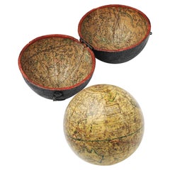
English Pocket Globe, London, Circa 1775-1798
By Herman Moll
Located in Milano, IT
Pocket globe
London, between 1775 and 1798
Re-edition of the globe of Hermann Moll (1678-1732) dated 1719
The globe is contained in its original case, which itself is covered in shark skin.
There are slight gaps in the original paint on the sphere. The case no longer closes.
The sphere measures 2.7 in (7 cm) in diameter whereas the case measures 2.9 in (7.4 cm) in diameter.
lb 0.22 (kg 0.1)
The globe is made up of twelve printed paper gores aligned and glued to the sphere.
In the North Pacific Ocean there is a cartouche with the inscription:
A Correct
Globe
with the new
Discoveries.
The celestial globe is depicted on the inside of the box and is divided into two hemispheres with the cartouche:
A correct globe
with ye new cons
relations of Dr.
Halley & c.
It shows the ecliptic divided into the days of the zodiacal calendar and the constellations represented as animals and mythological figures.
On the globe are delineated the equinoctial line, divided by degrees and hours, the ecliptic and the meridian (passing west of Greenwich). The continents are shaded and outlined in pink, green and yellow. It shows: the Cook routes; a wind rose in the Southern Indian Ocean; Antarctica without land; Africa with Negroland (Hermann Moll is considered the first geographer to name the West African region in his 1727 map. (Encyclopaedia Britannica, ed. 1902, under "States of Central Africa"); Tartary in Central Asia; the Mogul kingdom in northern India; in North America only New England, Virginia, Carolina, Florida, Mississippi are identified; California is already a peninsula; the northwest coast of America is "unknown parts" (Alaska is not described and it is only partially delineated, it was to become part of the United States in 1867); Mexico is named "Spain"; Central South America "Amazone America". Australia (which was to be so named after 1829) is called New Holland. The route of Admiral Anson is traced (1740) and the trade winds are indicated by arrows. (See Van der Krogt, P., Old Globes in the Netherlands, Utrecht 1984, p. 146 and Van der Krogt, P. - Dekker, E., Globes from the Western World, London 1993, pp. 115.)
Elly Dekker, comparing Moll’s 1719 globe and his re-edition (of which the one described above is a sample), identifies the differences between them: the two editions are quite similar to each other, but in the "anonymous" globe, compared to the previous globe of 1719, California looks like a proper peninsula - the reports of the Spanish explorers of the region had given rise to uncertainty over whether it was connected to the mainland or not. The geographical nature of California was confirmed after the explorations of Juan Bautista de Anza (1774-1776). The routes of Dampier's journey were partially erased and the route of Captain James Cook's first voyage was superimposed on them, and the geography of Australasia was adapted accordingly, including the denomination of the Cook Strait. See Dekker, Elly, Globes at Greenwich, 1999.
An important ante quem element is represented by Tasmania: it is not separated from Australia by the Bass Strait...
Category
Late 18th Century English George III Antique Herman Moll Furniture
Materials
Shagreen, Paper
Antique Map of Denmark by Moll 'circa 1730'
By Herman Moll
Located in Langweer, NL
Antique map titled 'Denmark, agreeable to Modern History'. Uncommon map of Denmark by Herman Moll, published, circa 1730.
Category
Mid-18th Century Antique Herman Moll Furniture
Materials
Paper
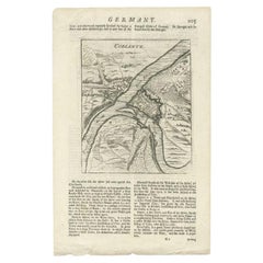
Antique Map of the Koblentz Region by Moll, 1695
By Herman Moll
Located in Langweer, NL
Antique map Koblentz titled 'Coblentz'. Rare antique map of the Koblentz region in Germany. On verso, an antique map of the Mont Royal fortress, Germany. Originates from 'Thesaurus Geographicus. A New Body of Geography: or a Compleat Description of the Earth 'by H. Moll.
Artists and Engravers: Herman Moll...
Category
17th Century Antique Herman Moll Furniture
Materials
Paper
Related Items
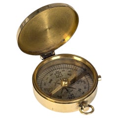
A brass pocket compass by Barker and Sons of London, English circa 1890
Located in Central England, GB
This superb compass has an enclosed case, which is made from heavy gauged brass. It is hinged on one side for opening and has a carrying ring opposite. And between there is a sliding...
Category
19th Century British Victorian Antique Herman Moll Furniture
Materials
Brass
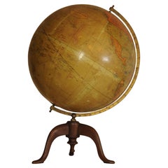
Antique World Globe From Fleet Street London 1923 on Wooden Stand
Located in Reading, Berkshire
Antique Terrestrial Geographia of Fleet Street London 12"inch World Globe on handcrafted Wooden Three Legged Base 1923
Made 55 Fleet Street, London
Beautiful desktop globe, sho...
Category
1920s British Art Deco Vintage Herman Moll Furniture
Materials
Wood, Paper
19th Century German Miniature Pocket Terrestrial Globe
By C. Abel-Klinger
Located in Essex, MA
A miniature 19th century 3.5 inch diameter pocket terrestrial globe by C. Abel-Klinger, Nuremberg, Germany, in English for the English speaking markets. Signed with cartouche reading...
Category
1880s German Antique Herman Moll Furniture
Materials
Brass
Antique Terrestrial Globe Published in 1940s by Girard Barrère et Thomas, Paris
Located in Milan, IT
Terrestrial globe published in the 1940s by Girard Barrère et Thomas 17, Rue de Buci Paris. Turned wooden base, papier mâché sphere covered with paper printed by engraving on copper ...
Category
1940s French Vintage Herman Moll Furniture
Materials
Wood, Paper
Antique Map of Principality of Monaco
By Antonio Vallardi Editore
Located in Alessandria, Piemonte
ST/619 - "Old Geographical Atlas of Italy - Topographic map of ex-Principality of Monaco" -
ediz Vallardi - Milano -
A somewhat special edition ---
Category
Late 19th Century Italian Other Antique Herman Moll Furniture
Materials
Paper
Original Antique Map of South East Asia by Thomas Clerk, 1817
Located in St Annes, Lancashire
Great map of South East Asia
Copper-plate engraving
Drawn and engraved by Thomas Clerk, Edinburgh.
Published by Mackenzie And Dent, 1817
Unframed.
Category
1810s English Antique Herman Moll Furniture
Materials
Paper
Floor Standing Globe On A Turned Hardwood & Brass Stand Model No 16
By Cram's
Located in Reading, Berkshire
Crams Imperial World Globe
Floor Standing Globe On A Turned Hardwood & Brass Stand Model No 16
Manufactured by George F Cram Co. Indiana, U.S.A
Category
Early 20th Century American Victorian Herman Moll Furniture
Materials
Brass
World Globe With Wooden Foot, and Brass 20th Century
Located in Mombuey, Zamora
Beautiful and elegant ball of the world to decorate any studio, living room or bedroom, it is small, with the base about 26 cm high and 10 wide.
Category
20th Century Italian Other Herman Moll Furniture
Materials
Brass
Original Antique Map of Ancient Greece, Achaia, Corinth, 1786
Located in St Annes, Lancashire
Great map of Ancient Greece. Showing the region of Thessaly, including Mount Olympus
Drawn by J.D. Barbie Du Bocage
Copper plate engraving by P.F Tardieu
Original hand color...
Category
1780s French Other Antique Herman Moll Furniture
Materials
Paper
Antique Hammond's 6-Inch Terrestrial Globe on Stand
By C.S. Hammond & Co.
Located in Philadelphia, PA
Offered here for your consideration is, A fine antique 6-inch terrestrial globe.
Additional Details:
By C.S. Hammond & Co.
The globe likely dates from 1927 to 1930 due to the ...
Category
20th Century Unknown Art Deco Herman Moll Furniture
Materials
Wood, Paper
19th Century French Table Globe / "Globe Terrestre" by J. Forest / Paris
Located in Dallas, TX
A well proportioned paper, plaster terrestrial globe standing on a turned ebonized base. GLOBE TERRESTRE
"Dressé par J. FOREST
GÉOGRAPHE
EN VENTE A PARIS
Chez l'Auteur
17 Rue de ...
Category
Late 19th Century French Late Victorian Antique Herman Moll Furniture
Materials
Plaster, Paper
English Campaign Trunk of Brass-Bound Leather and Camphor Wood, circa 1820
Located in Austin, TX
A handsome medium-sized British officer's military Campaign camphor trunk or chest of brass-bound and studded leather over camphor wood, circa 1820.
Manufactured by the British East India...
Category
Early 19th Century English Campaign Antique Herman Moll Furniture
Materials
Brass, Metal
H 13.13 in W 31.5 in D 16 in
Previously Available Items
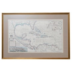
West-Indies Herman Moll William Paterson Spanish Trade Routes Gold
By Herman Moll
Located in BUNGAY, SUFFOLK
A rare map of the West-Indies or the islands of America in the North Sea with ye adjacent countries explaining what belongs to Spain, England, France, Holland &c also ye Trade Winds and ye several Tracts made by ye Galeons and flota from place to place.
Wil Paterson this map of the West-Indies is most humbly dedicated by Her. Moll geographer.
According to ye newest and most exact observations by Herman Moll Geographer.
Map of the Caribbean islands including southern North America, Mexico, Central America, and northern South America.
Inset at lower left: The City of Mexico in New Spain. Derived from a view in an unpublished atlas by Johannes Vingboons 1628. This image was probably copied from a map by Juan Gomez de Trasmonte, supervisor of the construction of a drainage system for Mexico city in 1628. Kagan, Urban images of the Hispanic world, fig. 4.23
Insets at upper right: La Vera Cruz; A Draught of the Bay and Citty of Havana Cuba; The Bay of Porto Bella; A Draught of ye Citty of Cartagena; A Draught of St. Augustin Saint Augustine, Florida.
Artist : Herman Moll d. 1732.
Bibliography : A new and compleat atlas, London, 1708-1720 Hermand Moll.
Provenance: Private collection.
In a buff mount and gilded frame with green highlight. Maps are generally framed in insigificant frames so that the attention is soley on the map. This map could easily be reframed depending on how and where it will be hung and there are many different choices.
Frame size height 56 cm., 22" length 84 cm., 33".
This is a map that reveals Moll both as an astute political observer and thinker, and tactian. This map of the West Indies is full of commercially sensitive information about the Spanish gold runs, and it is entirely feasible that the map was deliberately suited as a guide to English piracy and privateering in the West Indies. Through his London connections, Moll knew of two prominent English pirates or privateers: Woodes Rogers and William Dampier...
Category
18th Century Central American Baroque Antique Herman Moll Furniture
Materials
Paper
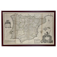
Framed Hand-Colored Early 18th Century Herman Moll Map of Spain and Portugal
By Herman Moll
Located in Alamo, CA
An 18th century copper plate engraved map of Spain and Portugal with attractive original outline hand-coloring entitled "A New And Exact Map Of Spain & Portugal Divided Into Its Kingdoms And Principalities & C., With Ye Principal Roads And Considerable Improvements, The Whole Rectifyd According To Ye. Newest Observations" by Herman Moll, first published in London in 1711. The cartouche in the right lower corner depicts a lion holder a sword atop a display of multiple coats of arms. Below are flags, armor and weapons.
The map is dedicated to Field Marshal John Campbell, 2nd Duke of Argyll, who commanded the British forces in Spain, during the War of Spanish Succession in 1711 and 1712. The English victories in the battles of Gibraltar and Fort Mahon are shown on the map. Also of interest is the 'Advertisment', containing one of Moll also includes the statement 'Among all ye Cheats that ye world are dayly abus'd with, none have lately been more Scandalous than that of Maps', which refers to the frequent plagiarism of his work by competitors.
The map is presented in an ornate black and brown wood frame with beaded design inner and outer margins, with a cream-colored mat. There are three vertical folds, as issued. There is mild discoloration along the right fold and minimal separation superiorly, as well as mild discoloration at the periphery of the margins and faint creases in the left lower corner and light or faded text in a small area on the left.
Herman Moll (1654-1732) was a prominent mapmaker in London in the early eighteenth century, having moved from Germany in the late 17th century. He initially worked for English printers, but soon opened his own establishment around 1690. He was a friend of the scientist Robert Hooke, the archaeologist William Stuckley, the authors Jonathan Swift and Daniel Defoe, and the pirates William Dampier...
Category
1710s English Antique Herman Moll Furniture
Materials
Paper
H 27.88 in W 42.13 in D 0.88 in
Antique Map of the Persian Empire 'Persia/Iran' by H. Moll, circa 1745
By Herman Moll
Located in Langweer, NL
Antique map titled 'Persia, agreable to Modern History'. Map of the Persian Empire extending from Georgia to Afghanistan. This map originates from 'Mo...
Category
Mid-18th Century English Antique Herman Moll Furniture
Materials
Paper
H 9.26 in W 14.77 in D 0.02 in
Herman Moll furniture for sale on 1stDibs.
Herman Moll furniture are available for sale on 1stDibs. These distinctive items are frequently made of paper and are designed with extraordinary care. There are many options to choose from in our collection of Herman Moll furniture, although white editions of this piece are particularly popular. Many of the original furniture by Herman Moll were created in the Georgian style in united kingdom during the 18th century and earlier. If you’re looking for additional options, many customers also consider furniture by Cary’s, John Speed, and John Ogilby. Prices for Herman Moll furniture can differ depending upon size, time period and other attributes — on 1stDibs, these items begin at $138 and can go as high as $9,670, while a piece like these, on average, fetch $3,399.
