Items Similar to Louisiana: A Framed 19th Century Map by O.W. Gray
Want more images or videos?
Request additional images or videos from the seller
1 of 10
Ormando Wyllis GrayLouisiana: A Framed 19th Century Map by O.W. Gray1873
1873
About the Item
This framed 19th century map of the Louisiana territory was published in "Gray's Atlas of the United States with General Maps of the World, accompanied by Descriptions Geographical, Historical, Scientific and Statistica" published in 1873 in Philadelphia by O.W. Gray and Son and Stedman, Brown and Lyon. It is a highly detailed map of Louisiana and adjacent portions of Mississippi to the east and Texas to the west, as the borders existed in the late 19th century. It includes portions of the Gulf of Mexico and towns and cities, such as New Orleans, Baton Rouge and Lafayette. Ormando Wyllis (O.W.) Gray (1829-1912) was a Civil and Topographical Engineer who became a cartographer and map atlas publisher.
The map is presented in a light brown distressed bleached wood frame with a cream mat. The frame measures 22.63" wide x 20" high x 0.88" deep. The map is somewhat toned, although the appearance appears in part to be related to its tinting. It is otherwise in very good condition.
There are two other mid-19th century maps of North America in identical style frames and maps that are listed on 1stdibs. They would make for an attractive and interesting display grouping. There is a discount available for multiple purchases. These additional maps may be viewed by entering their reference numbers in the search field: LU5206221574212 or LU5206221506302.
About the Seller
5.0
Platinum Seller
Premium sellers with a 4.7+ rating and 24-hour response times
Established in 2011
1stDibs seller since 2019
281 sales on 1stDibs
Typical response time: 2 hours
- ShippingRetrieving quote...Shipping from: Alamo, CA
- Return Policy
Authenticity Guarantee
In the unlikely event there’s an issue with an item’s authenticity, contact us within 1 year for a full refund. DetailsMoney-Back Guarantee
If your item is not as described, is damaged in transit, or does not arrive, contact us within 7 days for a full refund. Details24-Hour Cancellation
You have a 24-hour grace period in which to reconsider your purchase, with no questions asked.Vetted Professional Sellers
Our world-class sellers must adhere to strict standards for service and quality, maintaining the integrity of our listings.Price-Match Guarantee
If you find that a seller listed the same item for a lower price elsewhere, we’ll match it.Trusted Global Delivery
Our best-in-class carrier network provides specialized shipping options worldwide, including custom delivery.More From This Seller
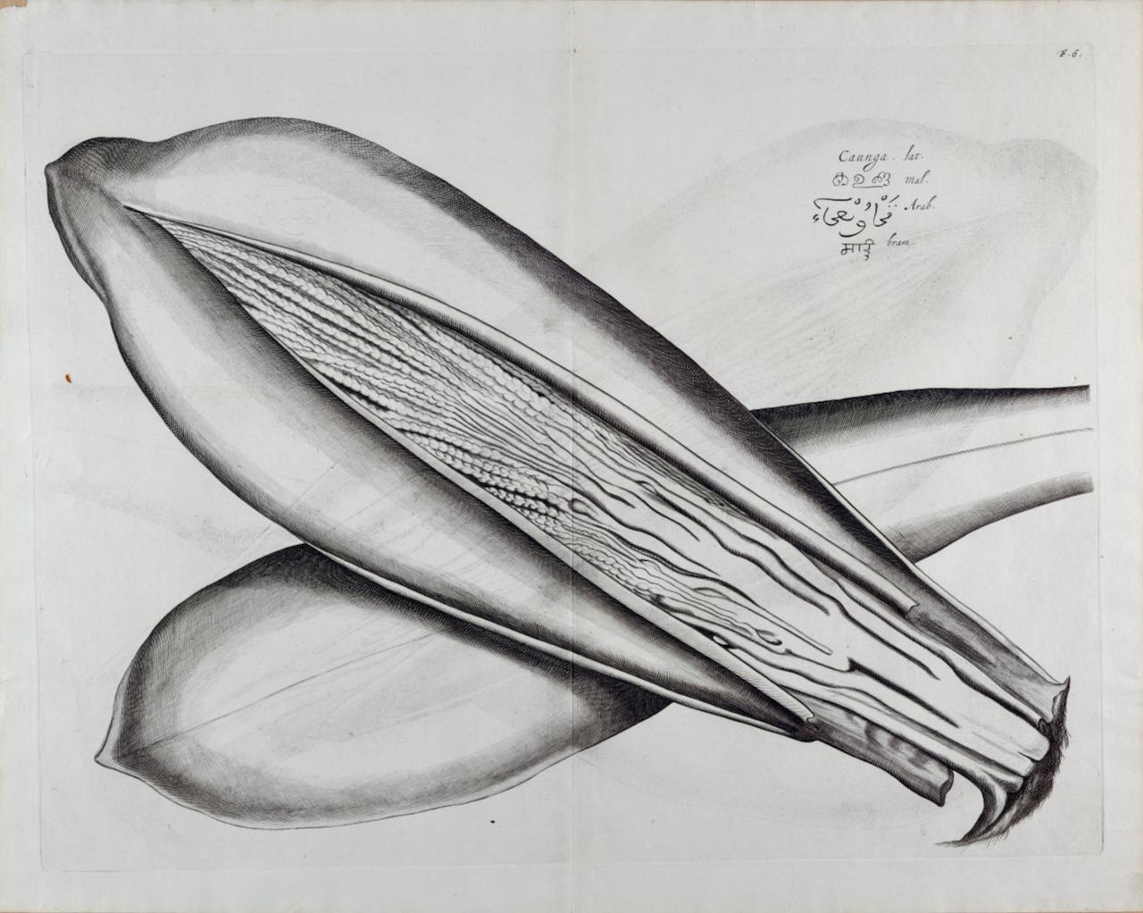
View AllCaunga Cucumber Plant: A 17th Century Botanical Engraving by Hendrik van Rheede
Located in Alamo, CA
This is a rare 17th century engraving of a plant entitled "Caunga" by the Dutch botanist Hendrik van Rheede tot Drakenstein, plate 6 from his 'Hortus Indicus Malabaricus' (Garden of Malabar), published in Amsterdam in 1686 by Johann van Someren. The engraving depicts the caunga plant, also known as Inca cucumber or horned squash, which is a climbing vine that produces edible, cucumber-like fruits. Rheede's 19th century publication featured illustrations of exotic plants and fruits labelled with script in the upper right corner in Latin, Malay, Arabic, and Sanskrit. Hortus Indicus Malabaricus is believed to be the earliest comprehensive published work on the flora of Asia and the tropics. The 17th century treatise featured important illustrations of 740 plants of the region, including Indian medicinal plants.
The engraving is printed on 17th century laid, chain-linked paper, watermarked with an elaborate crown design. The sheet measures 15.25" high by 18.88" wide. There is a central fold, as issued. There is a small dark spot on the left which appears to represent a paper inclusion which occurred when the hand-made paper was produced. The print is otherwise in excellent condition.
There are additional Rheede botanical engravings from his 'Hortus Indicus Malabaricus' publication that are listed on my 1stdibs storefront and online website. These would make for an impressive display grouping. A discount is available for purchase of two or more of the prints.
Hendrik Adriaan van Rheede tot Drakenstein...
Category
Late 17th Century Naturalistic Landscape Prints
Materials
Engraving
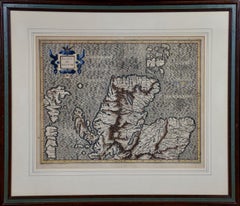
Northern Scotland: 16th Century Hand-colored Map by Mercator
By Gerard Mercator
Located in Alamo, CA
This is a framed hand-colored 16th century map of Northern Scotland by Gerard Mercator entitled "Scotiae pars Septentrionalis", published in Amsterdam in 1636. It is a highly detailed map of the northern part of Scotland, with the northwest Highlands and the cities Inverness and Aberdeen, as well as the Orkney Islands and the Hebrides. There is a decorative title cartouche in the upper left corner.
The map is presented in an antiqued brown wood...
Category
16th Century Other Art Style Landscape Prints
Materials
Engraving
West Africa: 18th Century Hand-colored Homann Map Entitled "Guinea Propria"
By Johann Baptist Homann
Located in Alamo, CA
This is a scarce richly hand colored copper plate engraved map of Africa entitled "Guinea Propria, nec non Nigritiae vel Terrae Nigrorum Maxima Pars" by Johann Baptist Homann (1664-1...
Category
1740s Other Art Style Prints and Multiples
Materials
Engraving

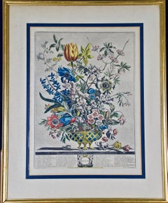
"February Bouquet" from 'The Twelve Months of Flowers' series by Robert Furber
By Robert Furber
Located in Alamo, CA
This framed hand-colored engraving entitled "February Bouquet" is from 'The Twelve Months of Flowers' by Henry Furber, published in London in 1730 by Robert Sayer and John King. Each of the twelve hand-colored engravings in the book were produced from paintings by Pieter Casteels (1684-1749) and engraved by Henry Fletcher (1710-1753). The book featured twelve detailed engravings of seasonal plants in bloom in the form of a bouquet. More than 400 different species of flowering plants were included with each plant numbered and accompanied by a list of the corresponding species names. Thirty-five species of flowers are depicted in this engraving in a bouquet sitting in an ornate attractive bowl. A few of the flowers lie loose on a table. The flower species are listed in a table in the lower portion of the plate, along with the month that these flowers are in bloom.
This colorful print is presented in a gold-colored wood frame with a cream-colored double mat with a heather green inner mat. The frame measures 23.5" High, 19" wide and 1.63" deep. There are a few small frame abrasions, but the print is in very good condition.
Robert Furber...
Category
Mid-18th Century Naturalistic Still-life Prints
Materials
Engraving
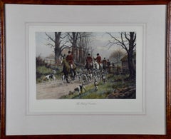
Engraving of a British Fox Hunting Scene "The Pink Of Condition"
By George Wright
Located in Alamo, CA
The engraving "The Pink Of Condition" by George Wright was published in London in 1909. It depicts the beginning of a British fox hunting scene. The ...
Category
Early 1900s Naturalistic Landscape Prints
Materials
Engraving
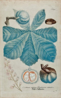
Flowering Chestnut Plant: 18th C. Hand-colored Botanical Engraving by Weinmann
By Johann Wilhelm Weinmann
Located in Alamo, CA
This hand-colored botanical mezzotint and line engraving by Johann Wilhelm Weinmann (1683-1741) is entitled "Castanea Equina, Chateignier amaire (Horse Chestnut)". It is plate 342 in...
Category
Mid-18th Century Naturalistic Still-life Prints
Materials
Engraving, Mezzotint
You May Also Like
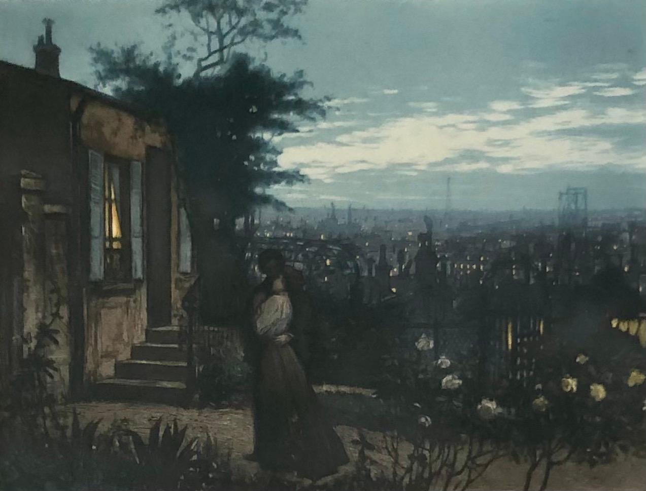
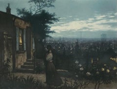
Two lovers in a garden above Paris
By Lionello Balestrieri
Located in Genève, GE
Ed: 31/300
Work on paper
Golden wooden frame with glass pane
68 x 85.5 x 2.5 cm
Category
Mid-20th Century Landscape Prints
Materials
Engraving
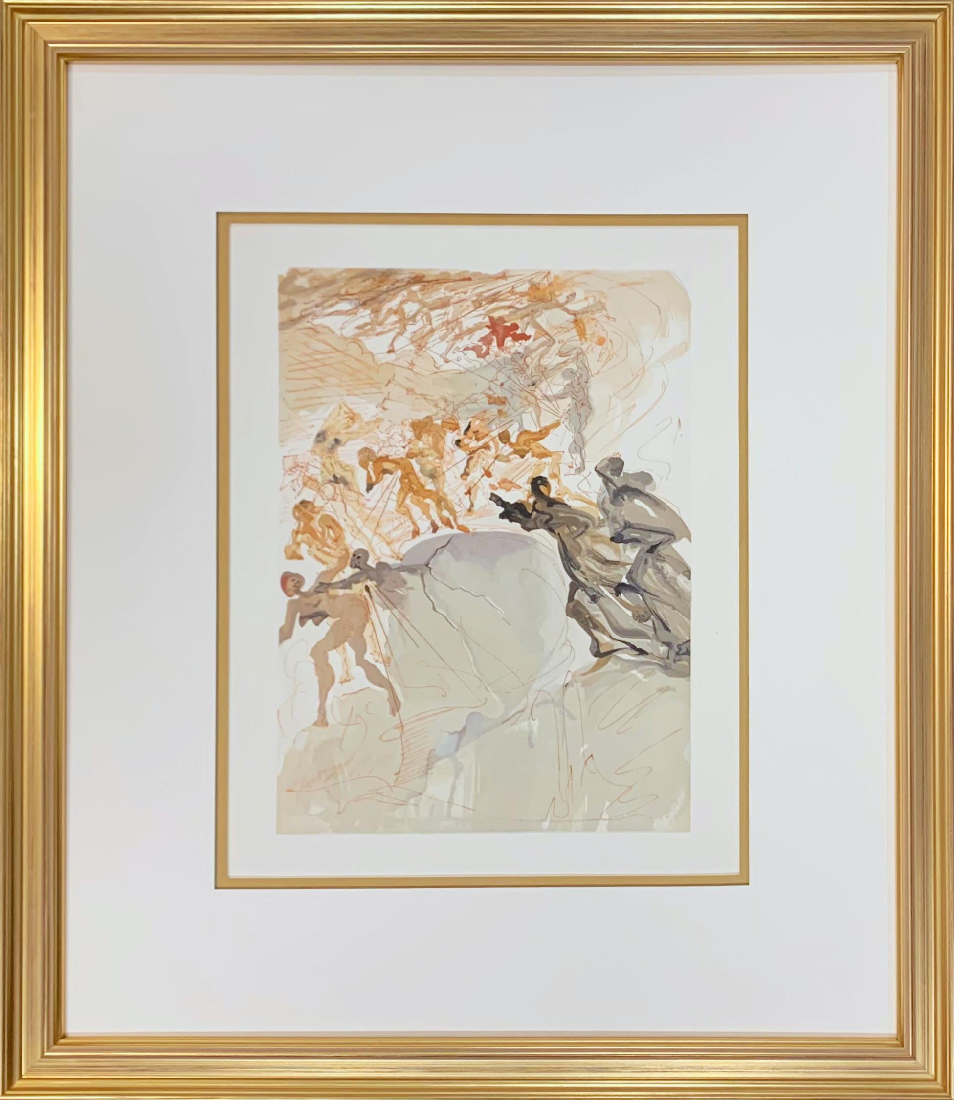
Purgatory: Canto 25 from The Divine Comedy
By Salvador Dalí
Located in Washington, DC
Artist: Salvador Dali
Medium: Woodblock engraving
Title: Purgatory Canto 25
Portfolio: The Divine Comedy: Purgatory
Year: 1963
Edition: 4765
Framed Size: 19 1/8" x 16 5/8"
Sheet Size...
Category
1960s Surrealist Figurative Prints
Materials
Engraving

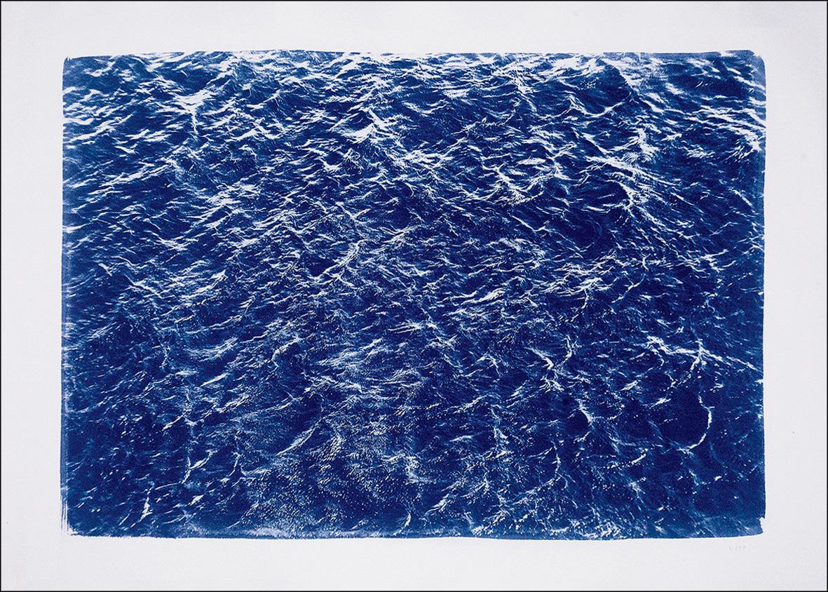
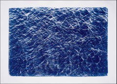
Pacific Ocean Currents, Handmade Cyanotype Seascape in Blue, Waves Landscape
By Kind of Cyan
Located in Barcelona, ES
This is an exclusive handprinted limited edition cyanotype.
"Pacific Ocean Currents" is a handmade cyanotype print of rough water texture resembling Pacific Ocean swell.
Details:
+ ...
Category
2010s Realist Abstract Drawings and Watercolors
Materials
Emulsion, Engraving, Etching, Paper
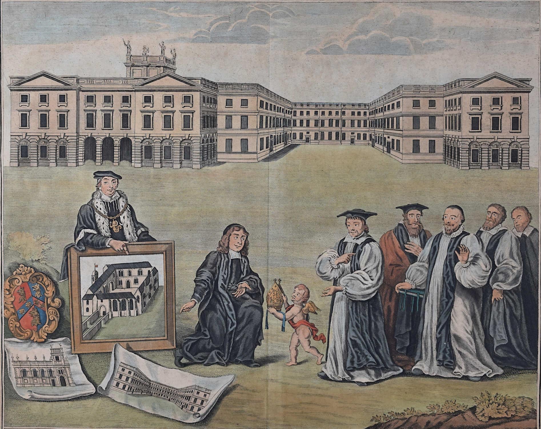
The Founder and Benefactors of Trinity College, Oxford, 18th Century engraving
Located in London, GB
To see our other views of Oxford and Cambridge , particularly suitable for wedding and graduation presents, scroll down to "More from this Seller" and below it click on "See all from...
Category
18th Century Other Art Style Figurative Prints
Materials
Engraving

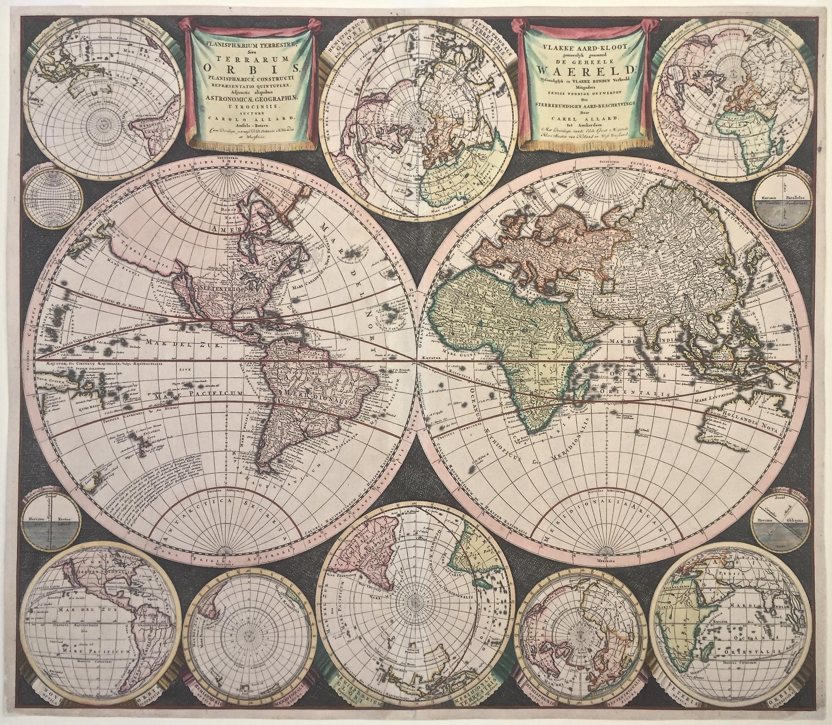
WORLD MAP - Planisphaerium Terrestre Sive Terrarum Orbis... 1696
By Carel Allard
Located in Santa Monica, CA
CAREL ALLARD (1648 – 1709)
PLANISPHAERIUM TERRESTRE SIVE TERRARUM ORBIS… 1696 (Shirley 578)
Engraving, 20 ½ x 23 ½”, sheet 21 x 24 1/8". A stunning double hemisphere World Map...
Category
17th Century Old Masters Landscape Prints
Materials
Engraving

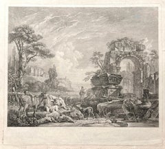
Les Bergers Romains, landscape with Roman ruins, 18th century engraving
Located in Melbourne, Victoria
Les Bergers Romains
Copper-line engraving by Jean Jacques Leveau (1729-1786) after Pierre Mettay (1728-1759). C1755.
Proof, before lettering. Laid, watermarked paper.
A landscap...
Category
18th Century French School Landscape Prints
Materials
Engraving