Items Similar to Came, the Seat of the Hon. Lionel Damer /// Dorsetshire John Hutchins English


Want more images or videos?
Request additional images or videos from the seller
1 of 15
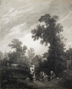
John HutchinsCame, the Seat of the Hon. Lionel Damer /// Dorsetshire John Hutchins English1796-1815
1796-1815
About the Item
Artist: John Hutchins (English, 1698-1773)
Title: "Came, the Seat of the Hon. Lionel Damer" (Plate 48)
Portfolio: The History and Antiquities of the County of Dorset
Year: 1796-1815 (Second edition)
Medium: Original Engraving on wove paper
Limited edition: Unknown
Printer: John Bowyer Nichols, London, UK
Publisher: Richard Gough and John Bowyer Nichols, London, UK
Reference: Brunet III, No. 389; Upcott I, No. 48, page 183
Sheet size: 9.19" x 15.5"
Image size: 7.19" x 11.88"
Condition: Some light foxmarks lower right in image and margins. Has been professionally stored away for decades. It is otherwise a strong impression in excellent condition
Notes:
Provenance: private collection - Aspen, CO. Engraved by English John Emes (1762-1810) after a drawing by English artist John Laporte (1761-1839). Comes from Hutchins' four volume "The History and Antiquities of the County of Dorset", (1796-1815) (Second edition), which consists of approx. 180 engravings. Printed from one copper plate in one color: black. John Hutchins' "The History and Antiquities of the County of Dorset" was originally published in 1774 (First edition) in a limited edition of 600, 1796-1815 (Second edition), and lastly 1861-1870) (Third edition).
Came House is a privately owned country house next to the village of Winterborne Came, in Dorset, England. Built in the mid-18th century, it is a Grade I listed building. The house was built for John Damer by Francis Cartwright of Blandford in 1754; after Cartwright's death in 1758 the interior was completed by Vile and Cobb, cabinet makers of London, in 1762. There is a kitchen wing on the east, connected to the house by a passageway. In the mid-19th century an entrance with porch, vestibule and cloakrooms, and a cast-iron domed conservatory, were added on the west side of the house. The conservatory is attributed to the architect Charles Fowler. A library was also established at that time and other minor changes were made. There have otherwise been few alterations.
Biography:
John Hutchins (1698–1773) was a Church of England clergyman and English topographer, who is best known as a county historian of Dorset. John Hutchins was born at Bradford Peverell, Dorset, on 21 September 1698. He was the son of Richard Hutchins (died 1734), who was for many years curate there, and from 1693 rector of All Saints Church, Dorchester. His mother, Anne, died on 9 April 1707, and was buried in Bradford Peverell church. His early education was under the Rev. William Thornton, master of Dorchester Grammar School, and on 30 May 1718 he matriculated at Hart Hall, Oxford. In the next spring (10 April) he migrated to Balliol College, and graduated B.A. on 18 January 1722, but for some unknown reason became M.A. from Magdalene College, Cambridge, in 1730.
Late in 1722 or early in 1723 he was ordained, and served as curate and usher to George Marsh, who from 1699 to 1737 was vicar of Milton Abbas and the master of its grammar school. In his native county Hutchins remained for the rest of his life. Through the interest of Jacob Bancks of Milton, he was instituted to the rectory of Swyre (Holy Trinity) on 22 August, and to that of Melcombe Horsey in 1733. He became rector of Holy Trinity, Wareham, on 8 March 1744, but he retained the cures of Swyre and Wareham until his death. Political agitation among his parishioners at Wareham involved him in difficulties, and his weak voice and growing deafness diminished his influence in the pulpit.
On Sunday, 25 July 1762, when the town of Wareham was devastated by fire and his rectory-house was burnt to ashes, his topographical papers were rescued by Mrs. Hutchins at the risk of her life. At the end of his days Hutchins was seized by a paralytic stroke, but he still laboured at his history of Dorset.
On 21 June 1773 Hutchins died, and was buried in the church of St. Mary's, Wareham, in the old chapel under its south aisle. A monument on the north wall of the church commemorated his memory. An engraving by John Collimore of a portrait of Hutchins by Cantlo Bestland appeared in Peregrine Bingham's "Memoir" (1813). Hutchins' library was sold by Thomas Payne in 1774.
- Creator:John Hutchins (1698 - 1773, English)
- Creation Year:1796-1815
- Dimensions:Height: 9.19 in (23.35 cm)Width: 15.5 in (39.37 cm)
- Medium:
- Movement & Style:
- Period:1790-1799
- Condition:
- Gallery Location:Saint Augustine, FL
- Reference Number:1stDibs: LU121214759032
About the Seller
5.0
Platinum Seller
Premium sellers with a 4.7+ rating and 24-hour response times
Established in 1978
1stDibs seller since 2015
1,306 sales on 1stDibs
Typical response time: <1 hour
- ShippingRetrieving quote...Shipping from: Saint Augustine, FL
- Return Policy
Authenticity Guarantee
In the unlikely event there’s an issue with an item’s authenticity, contact us within 1 year for a full refund. DetailsMoney-Back Guarantee
If your item is not as described, is damaged in transit, or does not arrive, contact us within 7 days for a full refund. Details24-Hour Cancellation
You have a 24-hour grace period in which to reconsider your purchase, with no questions asked.Vetted Professional Sellers
Our world-class sellers must adhere to strict standards for service and quality, maintaining the integrity of our listings.Price-Match Guarantee
If you find that a seller listed the same item for a lower price elsewhere, we’ll match it.Trusted Global Delivery
Our best-in-class carrier network provides specialized shipping options worldwide, including custom delivery.More From This Seller
View AllBenevolent Cottagers /// English Landscape Figurative Village Scene Engraving
Located in Saint Augustine, FL
Artist: (after) Sir Augustus Wall Callcott (English, 1779-1844)
Title: "Benevolent Cottagers"
Year: 1816
Medium: Original Etching and Engraving on laid paper
Limited edition: Unknown...
Category
1810s Old Masters Landscape Prints
Materials
Engraving, Etching, Laid Paper, Intaglio
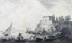
Départ Pour La Pêche (Maison de Campagne des Environs de Naples) /// Old Masters
Located in Saint Augustine, FL
Artist: Jean Daullé (French, 1703-1763)
Title: "Départ Pour La Pêche (Maison de Campagne des Environs de Naples)"
Circa: 1740
Medium: Original Engraving on watermarked laid paper
Lim...
Category
1740s Old Masters Landscape Prints
Materials
Laid Paper, Engraving
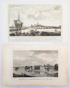
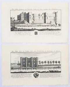
Set of Two Engravings from Nash's "History of Worcestershire" /// Landscapes Art
By Treadway Russell Nash
Located in Saint Augustine, FL
Artist: Treadway Russell Nash (English, 1724-1811)
Title: "The South View of the City of Worcester, from Digley Fields" and "Hewell, the Seat of the Right Honorable the Earl of Plymouth"
Portfolio: Collections for the History of Worcestershire
Year: 1781-1782 (First edition)
Medium: Set of Two Original Engravings on watermarked laid paper
Limited edition: Unknown
Printer: John Nichols, London, UK
Publisher: T. Payne and Son, J. Robson, B. White, Leigh and Sotheby, London, UK; Fletcher, Oxford, UK; and Lewis, Worcester, UK
Reference: Upcott III, page 1330
Sheet size (each): approx. 10.25" x 16.63"
Image size (each): approx. 7" x 12"
Condition: "The South View of the City of Worcester, from Digley Fields" has some minor foxmarks in margins. "Hewell, the Seat of the Right Honorable the Earl of Plymouth" has toning and uneven discoloration to its sheet. Have been professionally stored away for decades. They are both otherwise strong impressions, the first in excellent condition, and the second in good condition
Notes:
Provenance: private collection - Aspen, CO. "The South View of the City of Worcester, from Digley Fields" was engraved by English artist Thomas Sanders (Active: Mid-Late 18th Century) after a drawing by himself. "Hewell, the Seat of the Right Honorable the Earl of Plymouth" was engraved by English artist Michael Angelo Rooker (1743-1801) after a watercolor painting by English artist Paul Sandby (1731-1809). Comes from Nash's two volume "Collections for the History of Worcestershire", (1781-1782) (First edition), which consists of 75 engravings. Each work is printed from one copper plate in one color: black. There was a (Second edition) "with Additions" bound in with Volume II of this portfolio published by John White in (1799). And both the First and Second editions of "Collections for the History of Worcestershire" are based off Thomas Sanders' 1779-1781 "Perspective Views of the Market Towns within the County of Worcester". "The South View of the City of Worcester, from Digley Fields" has an unidentified watermark in the center of its sheet resembling "XV".
Biography:
Treadway Russell Nash (24 June 1724 – 26 January 1811) was an English clergyman, now known as an early historian of Worcestershire and the author of Collections for the History of Worcestershire, an important source document for Worcestershire county histories. He was a fellow of the Society of Antiquaries of London.
Treadway Russell Nash was born on 24 June 1724 born at Clerkenleap, in Kempsey, Worcestershire. His family were from Ombersley. They had lands there and at Claines, and had later bought lands in the Reformation around St Peter's, Droitwich. He was related to James Nash and John Nash, both MPs for Worcester. His father Richard, a grandson of Sir Rowland Berkeley, died in 1740, and Richard's eldest son in 1757. As a result, Treadway Russell Nash inherited the Russells' Strensham estates from his brother, as well as the Nash estates, and took both names.
He was educated from the age of twelve at King's School, Worcester, and became a scholar at Worcester College, Oxford aged fifteen. In March 1749, he accompanied his brother on a trip to the continent, to aid Richard's health. They visited Paris for about six weeks, before spending the summer "on the banks of the Loire". They then visited "Bourdeaux, Thoulouse, Montpelier, Marseilles, Leghorn, Florence, Rome, Naples, Bologna, Venice, Padua, Verona, Milan, Lyons, and again Paris"; such expeditions are often known as the Grand Tour.
On his return in late summer 1751, Nash took up a post as Vicar of Eynsham through his friend and future brother-in-law, John Martin. He also had an income as a tutor at Oxford. He took his Doctor of Divinity degree and left Oxford, having "gone out grand compounder", following the death of his brother. He also left his benefice at Eynsham in 1757. While at Oxford he had proposed a road from there to Witney (now the A40 and B4022), and also stood for Parliament. Nash married Margaret Martin...
Category
1780s Old Masters Landscape Prints
Materials
Laid Paper, Engraving, Intaglio
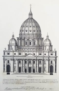
St Peters Church at Rome /// "Vitruvius Britannicus" Architecture Engraving Art
By Colen Campbell
Located in Saint Augustine, FL
Artist: Colen Campbell (Scottish, 1676-1729)
Title: "St Peters Church at Rome" (Vol. 1, Plate 6)
Portfolio: Vitruvius Britannicus; or The British Architect, Containing the Plans, Ele...
Category
1710s Old Masters Landscape Prints
Materials
Laid Paper, Engraving, Etching, Intaglio
"Torksey Hall" and "Newark Castle" from "Buck's Antiquities" /// Architecture UK
By Samuel & Nathaniel Buck
Located in Saint Augustine, FL
Artist: Samuel and Nathaniel Buck (English, 1696-1779) and (?-1759/1774)
Title: "Torksey Hall" (Plate 179) and "Newark Castle" (Plate 226)
Portfolio: Buck's Antiquities or Venerable ...
Category
1720s Old Masters Landscape Prints
Materials
Laid Paper, Engraving, Intaglio
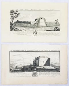
"Pendragon Castle" and "Lincoln Castle" from "Buck's Antiquities" /// British UK
By Samuel & Nathaniel Buck
Located in Saint Augustine, FL
Artist: Samuel and Nathaniel Buck (English, 1696-1779) and (?-1759/1774)
Title: "Pendragon Castle" (Plate 312) and "Lincoln Castle" (Plate 170)
Portfolio: Buck's Antiquities or Vener...
Category
1720s Old Masters Landscape Prints
Materials
Laid Paper, Engraving, Intaglio
You May Also Like
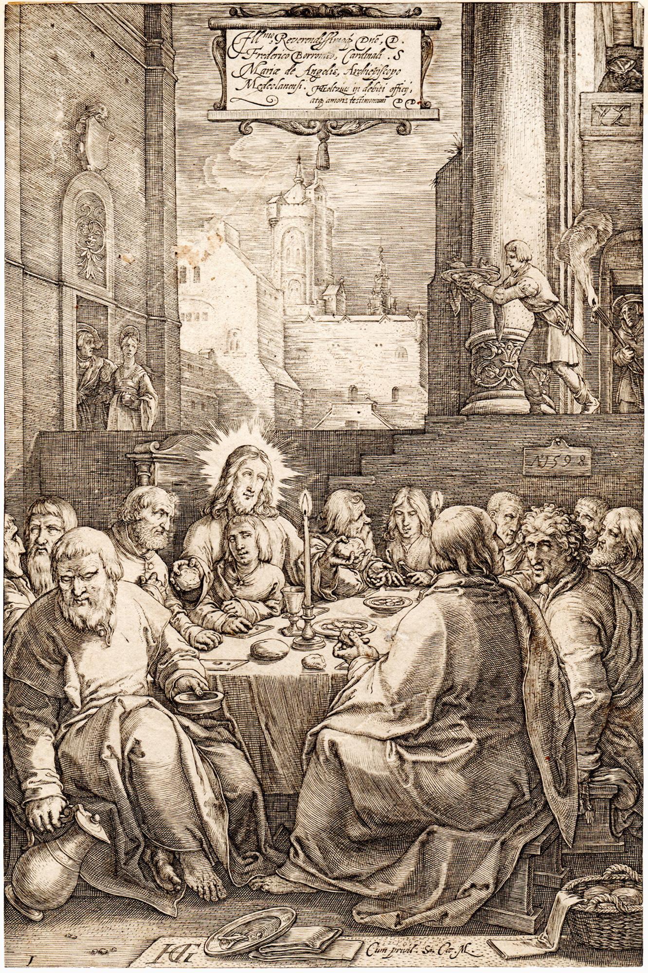
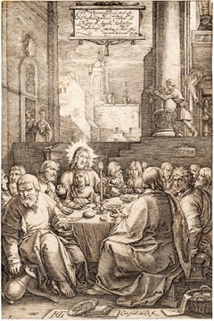
The Last Supper, from The Passion of Christ
By Hendrick Goltzius
Located in Middletown, NY
Engraving on cream laid paper, 8 x 5 3/8 inches (203 x 137 mm), trimmed at the platemark. A fine impression with a Coat of Arms watermark. Second state, after the addition of the Frederick de Witt...
Category
16th Century Old Masters Figurative Prints
Materials
Laid Paper, Engraving
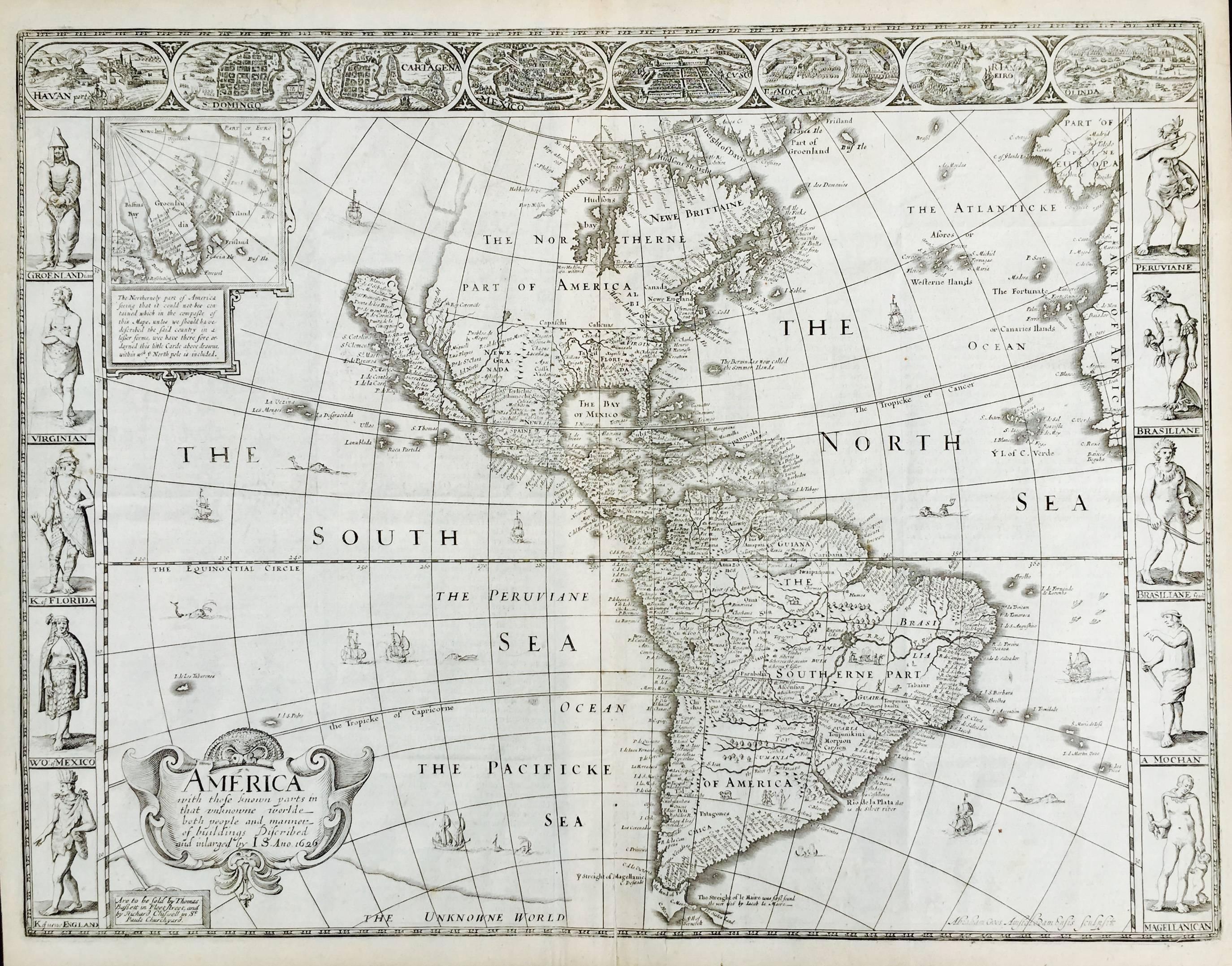
AMERICA
By John Speed
Located in Santa Monica, CA
IMPORTANT AMERICAN MAP - ONE OF THE FIRST TO SHOW CALIFORNIA as an ISLAND
JOHN SPEED (1552-1629)
AMERICA - With Those Known Parts In That Unknown Worlde (sic),
1626-(76)
(Burden 217 iv/iv) Engraving, uncolored. Engraved by Abraham Goos and
published by Thomas Basset and Richard Chiswell - 4th state of 4 in 1676
15 1/8 x 20 1/2” From “A Prospect of the Most Famous Parts of the
World”. Generally good condition. A repaired split in lower centerfold. This
is the most common version of this important map...
Category
1620s Old Masters Landscape Prints
Materials
Engraving

$4,000 Sale Price
52% Off
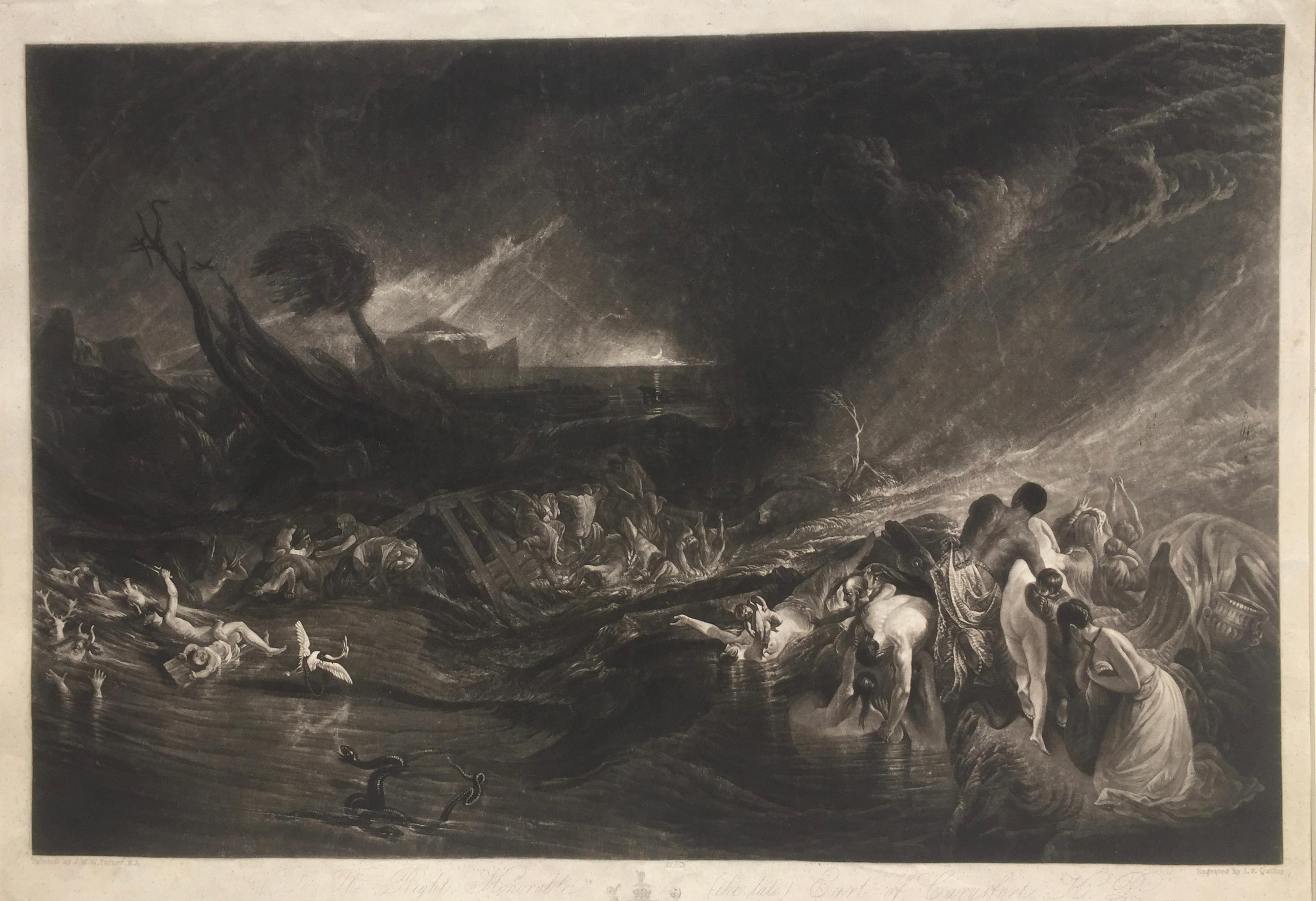
The Deluge - JOSEPH MALLORD WILLIAM TURNER (1775 - 1851)
By Joseph Mallord William Turner
Located in Santa Monica, CA
(after) JOSEPH MALLORD WILLIAM TURNER (1775 - 1851)
THE DELUGE, 1828. Mezzotint, Engraved by I. P. Quilly after a painting by J. M.W. Turner R.A.. Image ...
Category
1820s Old Masters Landscape Prints
Materials
Mezzotint

$3,200 Sale Price
20% Off
Frankfort, Germany: A 16th Century Hand-colored Map by Braun & Hogenberg
By Franz Hogenberg
Located in Alamo, CA
This is a 16th century original hand-colored copperplate engraved map of Frankfort, Germany entitled "Francenbergum, vel ut alij Francoburgum Hassiae Opp" by Georg Braun & Franz Hogenberg, from their famous city atlas "Civitates Orbis Terrarum", published in Cologne, Germany in 1595.
This is an English translation of an excerpt from the original text in the atlas:
"Frankenberg or, according to others, Francoburgum, a town in Hesse. Charlemagne vested the town of Frankenberg with many freedoms and privileges, which it still enjoys to this day, and on account of its valiant and victorious soldiers awarded a signet, upon which there formerly appeared a golden castle with a tower, together with the letter F and a golden crown.
Frankenberg, seen here from the northeast, lies on a hill above the River Eder. The hillside is covered with fields neatly separated by bushes and fences. Soaring above the town is the massive Liebfrauenkirche, which was modelled on St Elizabeth's church in Marburg. The New Town was founded in 1335 at the foot of the hill (right) and merged with the Old Town as late as 1556. Frankenberg was founded by Conrad of Thuringia in 1233/34 to prevent the archbishops of Mainz from expanding their sphere of influence...
Category
16th Century Old Masters Landscape Prints
Materials
Engraving

Meissen, Germany : A Large Framed 18th Century Map by Petrus Schenk
Located in Alamo, CA
This is a hand-colored 18th century map of the Meissen region of Germany, entitled "Geographischer Entwurff Derer Aemmter Meissen als Creys-Procuratur-Schul-und Stiffts-Ammt benebst ...
Category
Mid-18th Century Old Masters Landscape Prints
Materials
Engraving

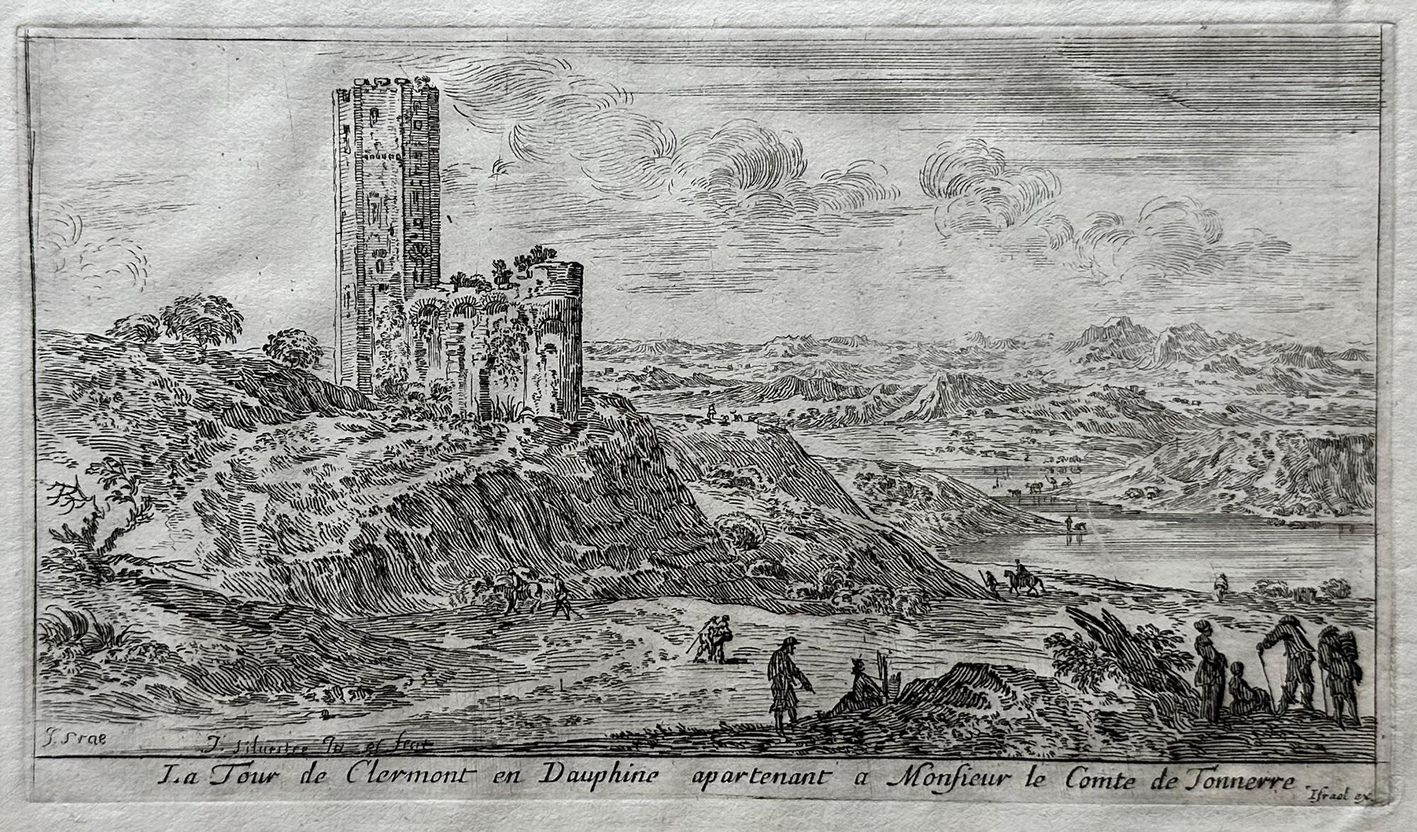
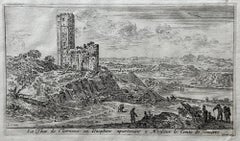
Le Tour de Clermont en Dauphine apartenant a Monsieur de Tonnerre
By Israel Silvestre
Located in Middletown, NY
Etching and engraving on handmade cream laid paper, 3 7/8 x 6 7/8 inches (97 x 173 mm), full margins. In good condition, consistent with age. Several small notations in pencil in t...
Category
18th Century Old Masters Landscape Prints
Materials
Handmade Paper, Laid Paper, Engraving, Etching
Recently Viewed
View AllMore Ways To Browse
Early English B
English Conservatory
Fire Seat
Old English Antique Plate
Antique Conservatories
Antique Conservatory
Used Church Seats
Vestibule Antique
Antique Kitchen Wall Art
Engraving Old West
George Iii Library
Antique Cast Iron Seat
Library Wall Cabinet
18th Century Library Cabinet
Antique Copper Wall Light
English Interior Engravings
Trinity Plate
Cast Iron Fire Plate