Items Similar to View of Emden, Germany: A 16th Century Hand-colored Map by Braun & Hogenberg


Want more images or videos?
Request additional images or videos from the seller
1 of 11
Franz HogenbergView of Emden, Germany: A 16th Century Hand-colored Map by Braun & Hogenberg1575
1575
About the Item
This is a 16th century original hand-colored copperplate engraved map of a bird's-eye View of Embden, Germany entitled " Emuda, vulgo Embden vrbs Frisia orientalis primaria" by Georg Braun & Franz Hogenberg, in volume II of their famous city atlas "Civitates Orbis Terrarum", published in Cologne, Germany in 1575.
This is a beautifully colored and detailed map of Emden, a seaport in northwestern Germany, along the Ems River and perhaps portions of over Dollart Bay, near the border with the Netherland. The map depicts a bird's-eye view of the city from the southwest, as well as a view of the harbor and an extensive system of canals. Numerous ships of various sizes, as well as two rowboats containing numerous occupants are seen in the main waterway in the foreground and additional boats line two canals in the center of the city. Two men and two women are shown on a hill in the foreground on the right, dressed in the 16th century style of nobility. Two ornate crests are included in each corner. A title strap-work cartouche is in the upper center with the title in Latin. The crest on the right including Engelke up de Muer (The Little Angel on the Wall) was granted by Emperor Maximilian I in 1495.
This is an English translation of an excerpt of Braun's description of Embden: "In Emden, the capital of East Frisia, rich merchants live in very fine houses. The city has a broad and well-situated harbour, which in my opinion is unique in Holland. Frisia and the whole of the Netherlands, for the ships can anchor here right under the city walls. They have also extended the harbour as far as the New Town, so that up to 400 ships can now find shelter here when the sea is rough."
The emphasis on the harbor and waterways within the city highlights the importance of Emden's place as a seaport at this time. Embden developed from a Dutch/Flemish trading settlement in the 7th-8th centuries into a city as late as late 14th century. In 1494 it was granted staple rights, and in 1536 the harbour was extended. In the mid-16th century Emden's port was thought to have the most ships in Europe. Its population then was about 5,000, rising to 15,000 by the end of the 16th century. The Ems River flowed directly under the city walls, but its course was changed in the 17th century by the construction of a canal. Emden has canals within its city limits, a typical feature of Dutch towns, which also enabled the extension of the harbor. In 1744 Emden was annexed by Prussia and is now part of Germany. It was captured by French forces in 1757 during the Seven Years' War, but recaptured by Anglo-German forces in 1758. During the Napoleonic French era, Emden and the surrounding lands of East Frisia were part of the short-lived Kingdom of Holland.
References:Van der Krogt 4, 1230, State 2; Taschen, Braun and Hogenberg, p.169.
This striking beautifully hand-colored city view is printed on laid, chain-linked paper with wide margins. The sheet measures 15.63" high by 21.25" wide. There is Latin on the front and Latin text on the verso. There is a central vertical fold as issued, which is reinforced. There is mild discoloration and a few spots in the margins and a few small focal areas of color loss. The map is otherwise in very good condition.
Braun and Hogenberg's 'The Civitates Orbis Terrarum' was the second atlas of maps ever published and the first atlas of cities and towns of the world. It is one of the most important books published in the 16th century. Most of the maps in the atlas were engraved by Franz Hogenberg and the text, with its descriptions of the history and additional factual information of the cities, was written by a team of writers and edited by Georg Braun. The work contained 546 bird-eye views and map views of cities and towns from all over the world. It gave graphic representation of the main features of the illustrated cities and towns, including the buildings and streets. Although the ordinary buildings are stylized, the principal buildings are reproduced from actual drawings created on location. The principal landmarks and streets can still be recognized today. In addition, the maps often include the heraldic arms of the city, the nature of the surrounding countryside, the important rivers, streams and harbors, even depicting stone bridges, wooden pontoons, flat-bottomed ferries, ships and working boats, wharves and jetties, as well as land-based activities, including horsemen, pedestrians, wagons, coaches, and palanquins. Small vignettes are often included which illustrate the trade, occupations and habits of the local inhabitants, such as agriculture, paper-making and textiles, as well as local forms of punishment, such as gibbets, wheels, floggings etc. Large figures dressed in their local costume are often presented out of proportion in the foreground. The aim of the authors was to give as much information as possible in a pleasing visual form. They succeeded in creating maps that were both informative and decorative works of art. The atlas is a wonderful glimpse of life in medieval Europe.
Georg Braun (1541-1622) was German Catholic cleric who was born and who died in Cologne, Germany. He was the principal editor of 'The Civitates Orbis Terrarum', acquiring the tables, hiring the artists, and composing the texts. Abraham Ortelius, whose Theatrum Orbis Terrarum of 1570 was the first atlas of maps ever published, assisted Braun in his compilation of the details and maps for the atlas. The Civitates was intended as a companion for the Ortellius' Theatrum, as suggested by the similarity in the titles. Braun was the only survivor of the original team to live to see the publication of last volume (VI) in 1617.
Franz Hogenberg (1535-1590) was a Flemish and German painter, engraver, and mapmaker. He was born in Mechelen (also known as Malines) in Flanders, the son of an engraver. After being expelled from Antwerp by the Duke of Alva, he moved to London and then eventually to Cologne, Germany, where he met Georg Braun and Abraham Ortellius. He engraved most of the plates for Ortelius's Theatrum and the majority of those in the Civitates. Many believe that he was responsible for originating the Civitates project.
Over a hundred of different artists and cartographers, the most significant of whom was Antwerp artist Georg (Joris) Hoefnagel (1542-1600), engraved the copper-plates of the Civitates from drawings. He not only contributed most of the original material for the Spanish and Italian towns but also reworked and modified those of other contributors. After Hoefnagel's death his son Jakob continued the work for the Civitates.
- Creator:Franz Hogenberg (1540 - 1590, Flemish)
- Creation Year:1575
- Dimensions:Height: 15.63 in (39.71 cm)Width: 21.25 in (53.98 cm)
- Medium:
- Movement & Style:
- Period:
- Framing:Framing Options Available
- Condition:
- Gallery Location:Alamo, CA
- Reference Number:Seller: # 48421stDibs: LU1173211338092
Franz Hogenberg
Braun and Hogenberg's 'The Civitates Orbis Terrarum' was the second atlas of maps ever published and the first atlas of cities and towns of the world. It is one of the most important books published in the 16th century. Most of the maps in the atlas were engraved by Franz Hogenberg and the text, with its descriptions of the history and additional factual information of the cities, was written by a team of writers and edited by Georg Braun. The work contained 546 bird-eye views and map views of cities and towns from all over the world. It gave graphic representation of the main features of the illustrated cities and towns, including the buildings and streets. Although the ordinary buildings are stylized, the principal buildings are reproduced from actual drawings created on location. The principal landmarks and streets can still be recognized today. In addition, the maps often include the heraldic arms of the city, the nature of the surrounding countryside, the important rivers, streams and harbors, even depicting stone bridges, wooden pontoons, flat-bottomed ferries, ships and working boats, wharves and jetties, as well as land-based activities, including horsemen, pedestrians, wagons, coaches, and palanquins. Small vignettes are often included which illustrate the trade, occupations and habits of the local inhabitants, such as agriculture, paper-making and textiles, as well as local forms of punishment, such as gibbets, wheels, floggings etc. Large figures dressed in their local costume are often presented out of proportion in the foreground. The aim of the authors was to give as much information as possible in a pleasing visual form. They succeeded in creating maps that were both informative and decorative works of art. The atlas is a wonderful glimpse of life in medieval Europe. Georg Braun (1541-1622) was German Catholic cleric who was born and who died in Cologne, Germany. He was the principal editor of 'The Civitates Orbis Terrarum', acquiring the tables, hiring the artists, and composing the texts. Abraham Ortelius, whose Theatrum Orbis Terrarum of 1570 was the first atlas of maps ever published, assisted Braun in his compilation of the details and maps for the atlas. The Civitates was intended as a companion for the Ortellius' Theatrum, as suggested by the similarity in the titles. Braun was the only survivor of the original team to live to see the publication of last volume (VI) in 1617. Franz Hogenberg (1535-1590) was a Flemish and German painter, engraver, and mapmaker. He was born in Mechelen (also known as Malines) in Flanders, the son of an engraver. After being expelled from Antwerp by the Duke of Alva, he moved to London and then eventually to Cologne, Germany, where he met Georg Braun and Abraham Ortellius. He engraved most of the plates for Ortelius's Theatrum and the majority of those in the Civitates. Many believe that he was responsible for originating the Civitates project.
About the Seller
5.0
Platinum Seller
Premium sellers with a 4.7+ rating and 24-hour response times
Established in 2011
1stDibs seller since 2019
281 sales on 1stDibs
Typical response time: 2 hours
- ShippingRetrieving quote...Shipping from: Alamo, CA
- Return Policy
Authenticity Guarantee
In the unlikely event there’s an issue with an item’s authenticity, contact us within 1 year for a full refund. DetailsMoney-Back Guarantee
If your item is not as described, is damaged in transit, or does not arrive, contact us within 7 days for a full refund. Details24-Hour Cancellation
You have a 24-hour grace period in which to reconsider your purchase, with no questions asked.Vetted Professional Sellers
Our world-class sellers must adhere to strict standards for service and quality, maintaining the integrity of our listings.Price-Match Guarantee
If you find that a seller listed the same item for a lower price elsewhere, we’ll match it.Trusted Global Delivery
Our best-in-class carrier network provides specialized shipping options worldwide, including custom delivery.More From This Seller
View AllDanube River, Italy, Greece and Croatia: A Hand-colored 18th C. Homann Map
By Johann Baptist Homann
Located in Alamo, CA
"Fluviorum in Europa principis Danubii" is a hand-colored map of the region about the Danube river created by Johann Baptist Homann (1663-1724) in his 'Atlas Novus Terrarum', publish...
Category
Early 18th Century Old Masters Landscape Prints
Materials
Engraving

L'Isle de France: A Hand-colored 17th Century Map by De Wit
By Frederick de Wit
Located in Alamo, CA
This colorful and detailed 17th century hand-colored copperplate map by Frederick De Wit was published in Amsterdam between 1666 and 1760. The map depicts the Île-de-France, which is one of the ancient provinces of France. Paris is located in the center of the map, with Versailles to the southwest The map extends from Rouen in the west to Reims in the east. The area around Paris, the Véxin Français, was the original domain of the king of France. Other areas were ruled by French feudal lords. For example, the Véxin Normand area was the domain of the Duke of Normandy...
Category
Early 18th Century Old Masters More Prints
Materials
Engraving

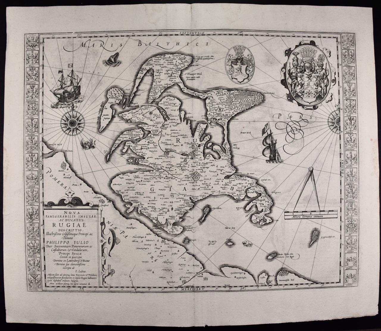
Rugen Island, Germany: An Early 17th Century Map by Mercator and Hondius
By Gerard Mercator
Located in Alamo, CA
This is an early 17th century map entitled "Nova Famigerabilis Insulae Ac Ducatus Rugiae Desciptio" (Map of Rugen Island, Germany) by Gerard Mercator and Henricus and Joducus Hondiu...
Category
Early 17th Century Old Masters Landscape Prints
Materials
Engraving

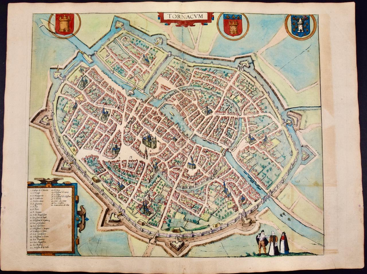
Tournai (Tournay), Belgium: A 16th Century Hand-colored Map by Braun & Hogenberg
By Franz Hogenberg
Located in Alamo, CA
This is a 16th century original hand-colored copperplate engraved map of Tournai, Belgium, entitled "Tornacum" by Georg Braun & Franz Hogenberg, in volume IV of their famous city atlas "Civitates Orbis Terrarum", published in Cologne or Augsberg, Germany in 1575. The map provides a bird's-eye view of the walled city of Tournai, the second oldest city in Belgium. It lies approximately one hour by car southwest of Brussels or from Ghent. The names of thirty of its streets, prominent buildings, churches and squares are listed in a key within a strap-work cartouche in the lower left. These locations are numbered in the key corresponding to their locations on the map.
This colorful map of Tournai (Tornacum or Tournay as it was called in the 16th century) includes the title in Latin in a cartouche in the upper center. Three crests are present across the upper map. A man and two woman are standing on a hill in the foreground in the lower right dressed in the style of 16th century upper class residents of the town.
This is an English translation of an excerpt of Braun's description of Tornai: “Tornacum or Turnacum is a city in Gallia Belgica, situated on the Schelde in the territory of the Nervii, called Tournai by its French inhabitants, but Dorneck by the Germans. Tournai has always been a large and powerful city, with an abundance of goods and commercial activities and wonderfully resourceful craftsmen, who invent new articles every day, and although some of these go out of use they constantly conceive of other new things, both useful and delightful, so that they have at all times something that provides work and a means of livelihood for the poor."
ReferencesVan der Krogt 4, 4435, State 1; Taschen, Braun and Hogenberg...
Category
16th Century Old Masters Landscape Prints
Materials
Engraving

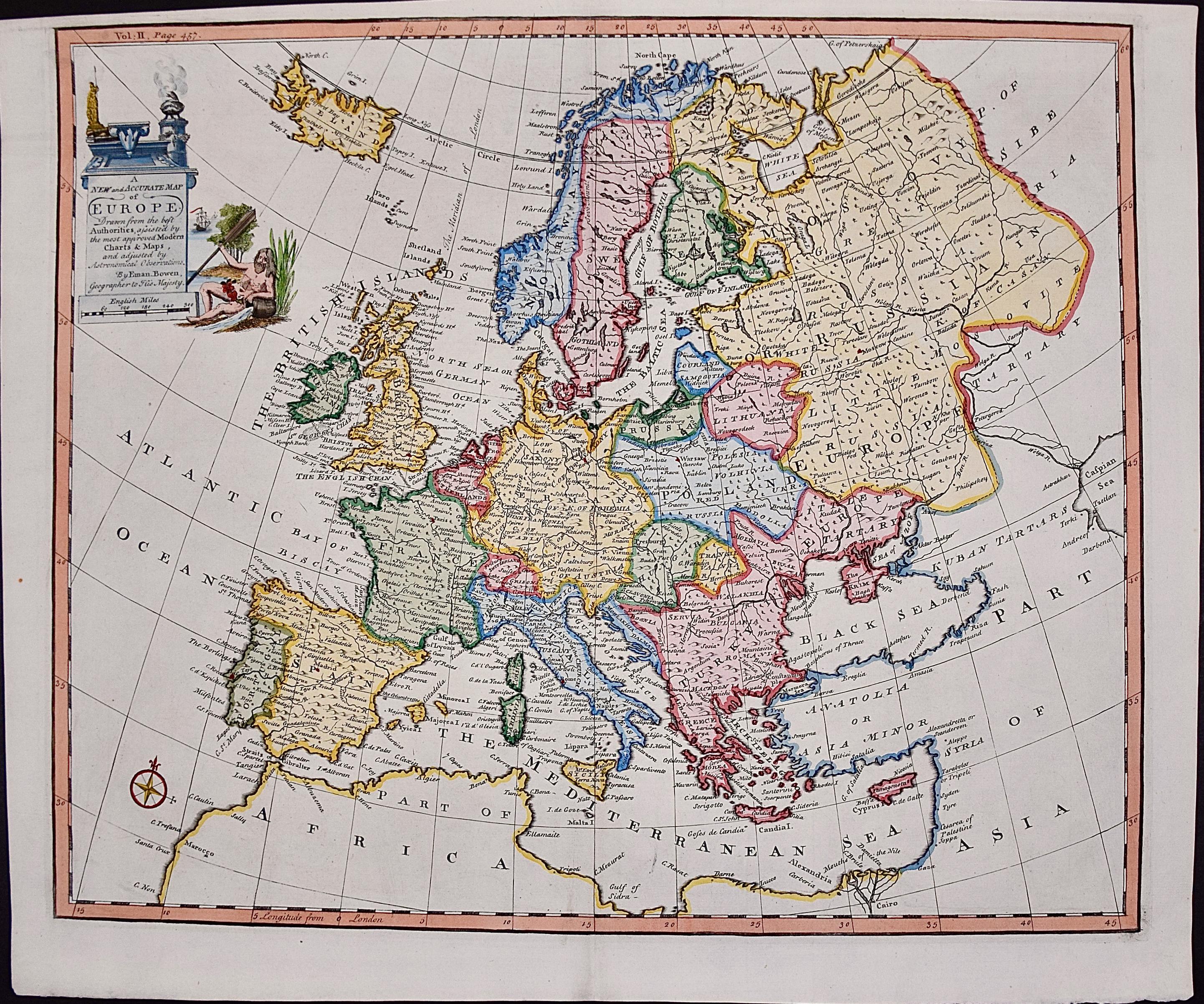
Europe: An Original 18th Century Hand-colored Map by E. Bowen
Located in Alamo, CA
This is an original 18th century hand-colored map entitled "A New & Accurate Map of Europe Drawn from the Best Authorities Assisted by the Most Improved Modern Charts and Maps." by E...
Category
Mid-18th Century Old Masters Landscape Prints
Materials
Engraving

Map of the World: An Original 18th Century Hand-colored Map by E. Bowen
Located in Alamo, CA
This is an original 18th century hand-colored map entitled "A New & Correct Chart of All The Known World Laid down according to Mercator's Projection" by Emanuel Bowen. It was published in 1744 in London in John Harris's "Navigantium atque Itinerantium Bibliotheca" or "A Complete Collection of Voyages and Travels". This highly detailed and colorful map depicts the world. as it was known in the mid 18th century. A majority of the northern and central portions of Canada and America are left blank due to the purity of knowledge at the time this map was published.
The map is embellished with four Compass Roses in the lower left, lower center, lower right and center, along with many rhumb lines. There a is a decorative title cartouche in the upper left. This colorful, attractive, historical and interesting 1744 map presents the entire world on Mercator's projection as it was understood in the middle part of the 18th century, before the landmark explorations of Captain’s Cook, Vancouver, Wilkes and others. It is an example of a nautical chart, a type of map that was designed specifically for use by mariners. The map is centered on the equator and includes both the Eastern and Western Hemispheres. The continents of North America, South America, Europe, Africa, and Asia are depicted, as well as various islands in the Atlantic, Pacific, and Indian Oceans. The map is laid out according to the Mercator projection, a type of cylindrical map projection that was developed in the 16th century by Flemish cartographer Gerardus Mercator. This projection has the advantage of preserving angles and shapes, making it useful for navigation. The map presents a paucity of inland detail, particularly for the Americas, but major cities, geographical landmarks, and regions are included. Ocean currents and Tradewinds are identified, as well as the magnetic declination lines or magnetic variance, which refers to the difference between true north and compass north. The continents are color coded, enhancing the beauty of this map. The three compass roses indicate the directions of the cardinal points.
The depiction of the western coast of America, the Pacific and Australia are interesting. There was very little exploration of Australia between the navigations of William Damper in 1699 and Tobias Furneaux in 1773. Most of the maps detail relies on the 17th century Dutch expeditions to Australia's western coast, by Abel Tasman and William Janszoon. Van Diemen's Land (Tasmania) and New Guinea appear connected to the Australian continent. New Zealand appears as a single landmass. North of New Zealand there is a landmass labelled 'Ter d' St. Esprit' which probably represents the New Hebrides Islands. This map precedes the accurate exploration of the South Pacific and east coast of Australia by Captain James Cook later in the 18th century. The map includes ‘Drakes' Port,' the site where Sir Francis Drake supposedly landed in 1579 during his 1579 circumnavigation of the globe. Here he claimed territory for England, restocked, and repaired his vessels. Drake named the region New Albion. The exact location of Drake's Port is a cartographic mystery. Drake's Harbor is believed to be in the region of San Francisco Bay, Bodega Bay, San Pablo Bay...
Category
Mid-18th Century Old Masters Landscape Prints
Materials
Engraving

You May Also Like
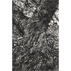
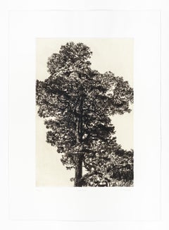
Winter Chestnut, Limited edition print, Landscape, Tree, Nature art
By Fiona Hamilton
Located in Deddington, GB
Scots Pine drypoint etching printed onto Japanese gampi tissue and backed onto German Hahnemule printmaking paper. This print depicts a mature pine tree, standing proud from the rest...
Category
2010s Contemporary Landscape Prints
Materials
Drypoint, Etching
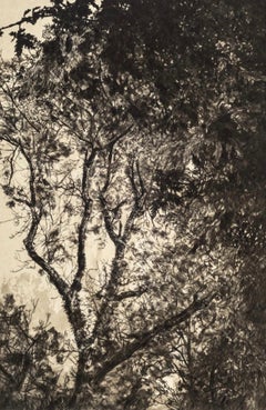
Autumn Pine, Limited edition print, Landscape, Tree, Nature art
By Fiona Hamilton
Located in Deddington, GB
This print of a pine tree uses kitakata Japanese tissue chine collé to depict the warmth and colour of early autumnal light. It is then backed onto Hahnemule printmaking paper. The subject matter is from Ashton Court Estate in Bristol. This body of work is based on the book by Suzanne Simard, 'Finding the Mother Tree'. Trees communicate via mycorrhizal fungi to trade water and other nutrients. Ancient and mature trees nurture their offspring via these networks, as well as trading nutrients between other species. Botanist Simard has spent years working on this theory as part of a wider body of work, discovering what it means for forests, the climate and the wider Anthropocene. My work explores the ecological sublime and an appreciation of the majesty of nature. I use detailed intaglio etching, drypoint, lithography and chine collé to draw the viewer into an ethereal landscape that has an impact on our sense of place in relation to the natural world. I use primarily black and white with natural tones of chine collé and sometimes layers of lithographic texture to introduce warmth to the stark palette and to invoke a sublime emotional connection. I work from sketches, photographs, notes and memory to create my prints.
ADDITIONAL INFORMATION:
Black & White, Chine Collé, Drypoint, Drypoint print, Etching, Etching print on Paper
Edition of 20
44 H x 32 W x 1 D cm (17.32 x 12.60 x 0.39 in)
Sold unframed
Image size:
Height: 30cm (11.81 in)
Width: 20cm (7.87 in)
Complete size of sheet
Height: 44cm (17.32 in)
Width: 32cm (12.60 in)
Depth: 1cm (0.39 in)
ARTIST BIOGRAPHY:
Fiona Hamilton is a printmaker based in Bristol. Interested in process she uses a combination of mediums, both traditional and contemporary, to produce unique imagery, often as one off pieces or in small limited editions. She currently works in silkscreen, cyanotype and foil.
Fiona’s artwork draws on a lot of natural themes such as plants, leaves, trees and creatures including lots of birds. She mostly works directly from nature or from photographs she has taken. She regularly lugs a heavy telephoto lens about to get photos of birds...
Category
2010s Contemporary Landscape Prints
Materials
Drypoint, Etching
Autumn Light, Limited edition print, Landscape, Tree, Nature art
By Fiona Hamilton
Located in Deddington, GB
Drypoint print onto photolitho printed kitakata with subtle gold ink and mounted onto Hahnemule printmaking paper. This print of a tree uses litho printed kitakata chine collé to dep...
Category
2010s Contemporary Landscape Prints
Materials
Drypoint, Etching
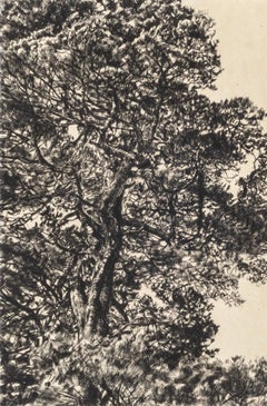
Greville Smyth Pine, Limited edition print, Landscape, Tree, Nature art
By Fiona Hamilton
Located in Deddington, GB
A very detailed drypoint etching of a Pine tree printed onto gampi Japanese tissue and backed onto Hahnemule printmaking paper. This print considers how we view the contemporary sublime landscape and how easy it can be to experience when we take the time to look. We often don’t have to travel far: parks in cities, the coastline and stars in the night sky. The mature Scots Pine tree pictured...
Category
2010s Contemporary Landscape Prints
Materials
Drypoint, Etching
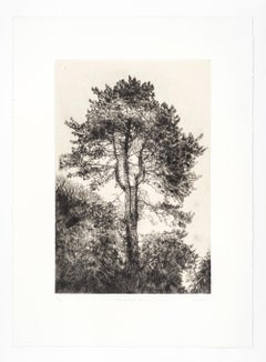
Scots Pine, Limited edition print, Landscape, Tree, Nature art
By Fiona Hamilton
Located in Deddington, GB
Scots Pine drypoint etching printed onto Japanese gampi tissue and backed onto German Hahnemule printmaking paper. This print depicts a mature pine tree, standing proud from the rest...
Category
2010s Contemporary Landscape Prints
Materials
Drypoint, Etching
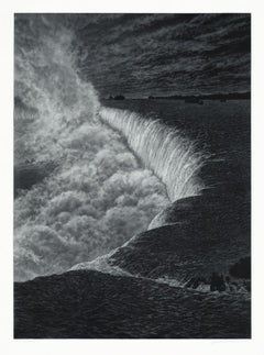
Niagara
By Frederick Mershimer
Located in New York, NY
NIAGARA
Contemporary artist Frederick Mershimer created the mezzotint engraving entitled “Niagara” in 2021. This impression is signed, titled, dated, and inscribed “5/45”- the 5th ...
Category
21st Century and Contemporary American Realist Landscape Prints
Materials
Mezzotint
Recently Viewed
View AllMore Ways To Browse
Germany A
16th Century Dutch
16th Century Plate
Netherlands 16th Century
Hand Colored Map
16th Century German
Hand Colored Italian Engraving
16th Century Stone
German Copper Plates
16th Century Textiles
14th Century European
16th Century Dress
17th Century German Engravings
Hand Colored Copper Engraving
Taschen Germany
French 16th Table
17th Century Dutch Table
17th Century Stone Well