Items Similar to New Map of the Terraqueous Globe - WORLD MAP - CALIFORNIA AS AN ISLAND


Want more images or videos?
Request additional images or videos from the seller
1 of 14
Edward WellsNew Map of the Terraqueous Globe - WORLD MAP - CALIFORNIA AS AN ISLAND1700-1701
1700-1701
About the Item
EDWARD WELLS (British 1667- 1727)
A NEW MAP of the TERRAQUEOUS GLOBE - according to the latest Discoveries and most general Divisions of it into CONTINENTS and OCEANS, 1700-01 (Shirley 609)
Engraved by Michael Burghers, Oxford. Hand-colored, Platemark 14 1/4 x 20 1/8 inches. Central cartouche flanked by figures representing the continents with dedication to William, Duke of Gloucester. Young men in study at lower corners. A decorative view featuring Oxford. From "A New Sett of Maps both of Ancient and Present Geography". The atlas compiled by mathematician and geographer Edward Wells (1667-1727) and dedicated to the young William, Duke of Gloucester who was Queen Anne's last surviving son and heir to the throne. Some remnants of foxing in the margins., other minor discoloration. The usual centerfold found on atlas maps.
Discoloration is accentuated in the photos.
This is the second version of this very attractive, decorative and simplified design, created for the education of Duke William. Shows California as an Island, a portrayal that still remained in some maps for another half century. It was disproven by Spanish explorer Father Kino at the time of the creation of this map
- Creator:Edward Wells (1667 - 1727, British)
- Creation Year:1700-1701
- Dimensions:Height: 14.25 in (36.2 cm)Width: 20.125 in (51.12 cm)
- Medium:
- Movement & Style:
- Period:1700-1709
- Condition:
- Gallery Location:Santa Monica, CA
- Reference Number:1stDibs: LU41136082442
About the Seller
5.0
Recognized Seller
These prestigious sellers are industry leaders and represent the highest echelon for item quality and design.
Established in 1977
1stDibs seller since 2016
284 sales on 1stDibs
Typical response time: 2 hours
Associations
International Fine Print Dealers Association
- ShippingRetrieving quote...Shipping from: Santa Monica, CA
- Return Policy
Authenticity Guarantee
In the unlikely event there’s an issue with an item’s authenticity, contact us within 1 year for a full refund. DetailsMoney-Back Guarantee
If your item is not as described, is damaged in transit, or does not arrive, contact us within 7 days for a full refund. Details24-Hour Cancellation
You have a 24-hour grace period in which to reconsider your purchase, with no questions asked.Vetted Professional Sellers
Our world-class sellers must adhere to strict standards for service and quality, maintaining the integrity of our listings.Price-Match Guarantee
If you find that a seller listed the same item for a lower price elsewhere, we’ll match it.Trusted Global Delivery
Our best-in-class carrier network provides specialized shipping options worldwide, including custom delivery.More From This Seller
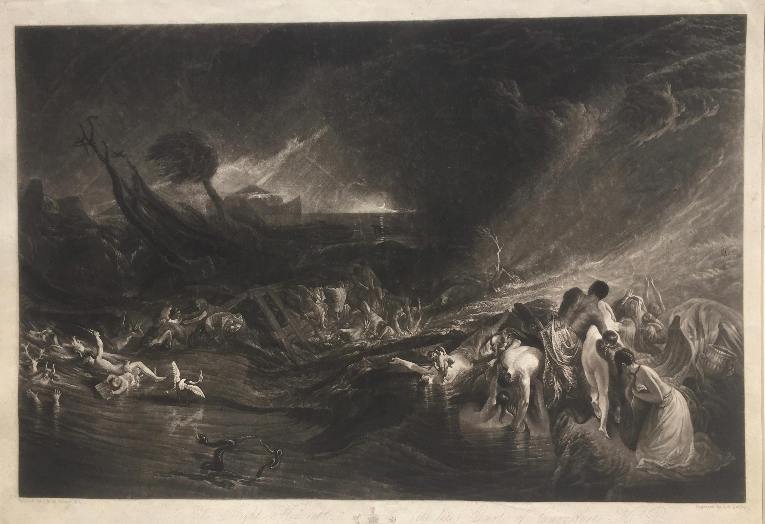
View AllThe Deluge - JOSEPH MALLORD WILLIAM TURNER (1775 - 1851)
By Joseph Mallord William Turner
Located in Santa Monica, CA
(after) JOSEPH MALLORD WILLIAM TURNER (1775 - 1851)
THE DELUGE, 1828. Mezzotint, Engraved by I. P. Quilly after a painting by J. M.W. Turner R.A.. Image ...
Category
1820s Old Masters Landscape Prints
Materials
Mezzotint

$3,200 Sale Price
20% Off
WORLD MAP - Planisphaerium Terrestre Sive Terrarum Orbis... 1696
By Carel Allard
Located in Santa Monica, CA
CAREL ALLARD (1648 – 1709)
PLANISPHAERIUM TERRESTRE SIVE TERRARUM ORBIS… 1696 (Shirley 578)
Engraving, 20 ½ x 23 ½”, sheet 21 x 24 1/8". A stunning double hemisphere World Map...
Category
17th Century Old Masters Landscape Prints
Materials
Engraving

PERU
By Johannes Jansson
Located in Santa Monica, CA
JOHANNES JANSSON (1588 - 1664)
PERU, engraving with early coloring. Platemark 15 1/8 x 19 3/8 inches, sheet 17 x 20 1/2
A nice example of one of the earliest maps of Peru. From the ...
Category
1630s Old Masters Landscape Prints
Materials
Engraving

AMERICAE - Sive Novi Orbis, Nova Descriptio
By Abraham Ortelius
Located in Santa Monica, CA
ABRAHAM ORTELIUS (1527 - 1598)
AMERICAE SIVE NOVI ORBIS, NOVA DESCRIPTIO, 1587 (1603) (Van Den Broecke 11, Burden 64; Schwartz & Ehrenberg 69)
Engraving. A very good, well printed...
Category
16th Century Old Masters Landscape Prints
Materials
Engraving

AMERICA
By John Speed
Located in Santa Monica, CA
IMPORTANT AMERICAN MAP - ONE OF THE FIRST TO SHOW CALIFORNIA as an ISLAND
JOHN SPEED (1552-1629)
AMERICA - With Those Known Parts In That Unknown Worlde (sic),
1626-(76)
(Burden 217 iv/iv) Engraving, uncolored. Engraved by Abraham Goos and
published by Thomas Basset and Richard Chiswell - 4th state of 4 in 1676
15 1/8 x 20 1/2” From “A Prospect of the Most Famous Parts of the
World”. Generally good condition. A repaired split in lower centerfold. This
is the most common version of this important map...
Category
1620s Old Masters Landscape Prints
Materials
Engraving

$4,000 Sale Price
52% Off
VEDUTA DEGLI AVANZI De’MAUSOLEI E DELLE FABBRICHE…...
By Giovanni Battista Piranesi
Located in Santa Monica, CA
GIOVANNI BATTISTA PIRANESI (Italian 1720-1778)
VEDUTA DEGLI AVANZI De’MAUSOLEI E DELLE FABBRICHE…c 1756 (Hind 83; Focillon 20.A.293; Giesecke 116; Wilton-E...
Category
1750s Old Masters Landscape Prints
Materials
Etching
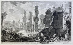
$2,000 Sale Price
20% Off
You May Also Like
Frankfort, Germany: A 16th Century Hand-colored Map by Braun & Hogenberg
By Franz Hogenberg
Located in Alamo, CA
This is a 16th century original hand-colored copperplate engraved map of Frankfort, Germany entitled "Francenbergum, vel ut alij Francoburgum Hassiae Opp" by Georg Braun & Franz Hogenberg, from their famous city atlas "Civitates Orbis Terrarum", published in Cologne, Germany in 1595.
This is an English translation of an excerpt from the original text in the atlas:
"Frankenberg or, according to others, Francoburgum, a town in Hesse. Charlemagne vested the town of Frankenberg with many freedoms and privileges, which it still enjoys to this day, and on account of its valiant and victorious soldiers awarded a signet, upon which there formerly appeared a golden castle with a tower, together with the letter F and a golden crown.
Frankenberg, seen here from the northeast, lies on a hill above the River Eder. The hillside is covered with fields neatly separated by bushes and fences. Soaring above the town is the massive Liebfrauenkirche, which was modelled on St Elizabeth's church in Marburg. The New Town was founded in 1335 at the foot of the hill (right) and merged with the Old Town as late as 1556. Frankenberg was founded by Conrad of Thuringia in 1233/34 to prevent the archbishops of Mainz from expanding their sphere of influence...
Category
16th Century Old Masters Landscape Prints
Materials
Engraving

Meissen, Germany : A Large Framed 18th Century Map by Petrus Schenk
Located in Alamo, CA
This is a hand-colored 18th century map of the Meissen region of Germany, entitled "Geographischer Entwurff Derer Aemmter Meissen als Creys-Procuratur-Schul-und Stiffts-Ammt benebst ...
Category
Mid-18th Century Old Masters Landscape Prints
Materials
Engraving

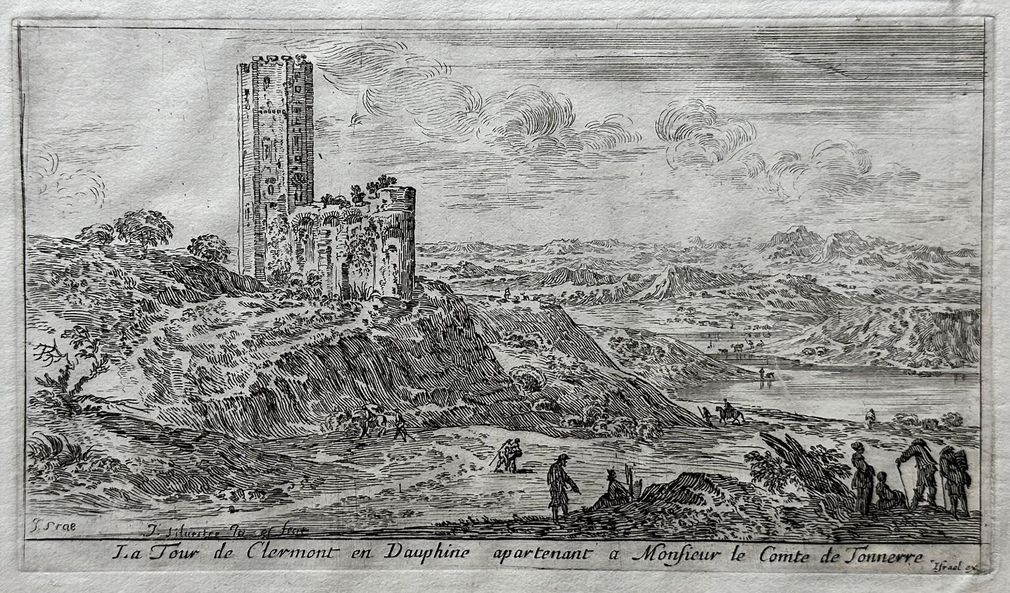
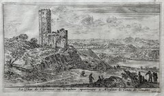
Le Tour de Clermont en Dauphine apartenant a Monsieur de Tonnerre
By Israel Silvestre
Located in Middletown, NY
Etching and engraving on handmade cream laid paper, 3 7/8 x 6 7/8 inches (97 x 173 mm), full margins. In good condition, consistent with age. Several small notations in pencil in t...
Category
18th Century Old Masters Landscape Prints
Materials
Handmade Paper, Laid Paper, Engraving, Etching
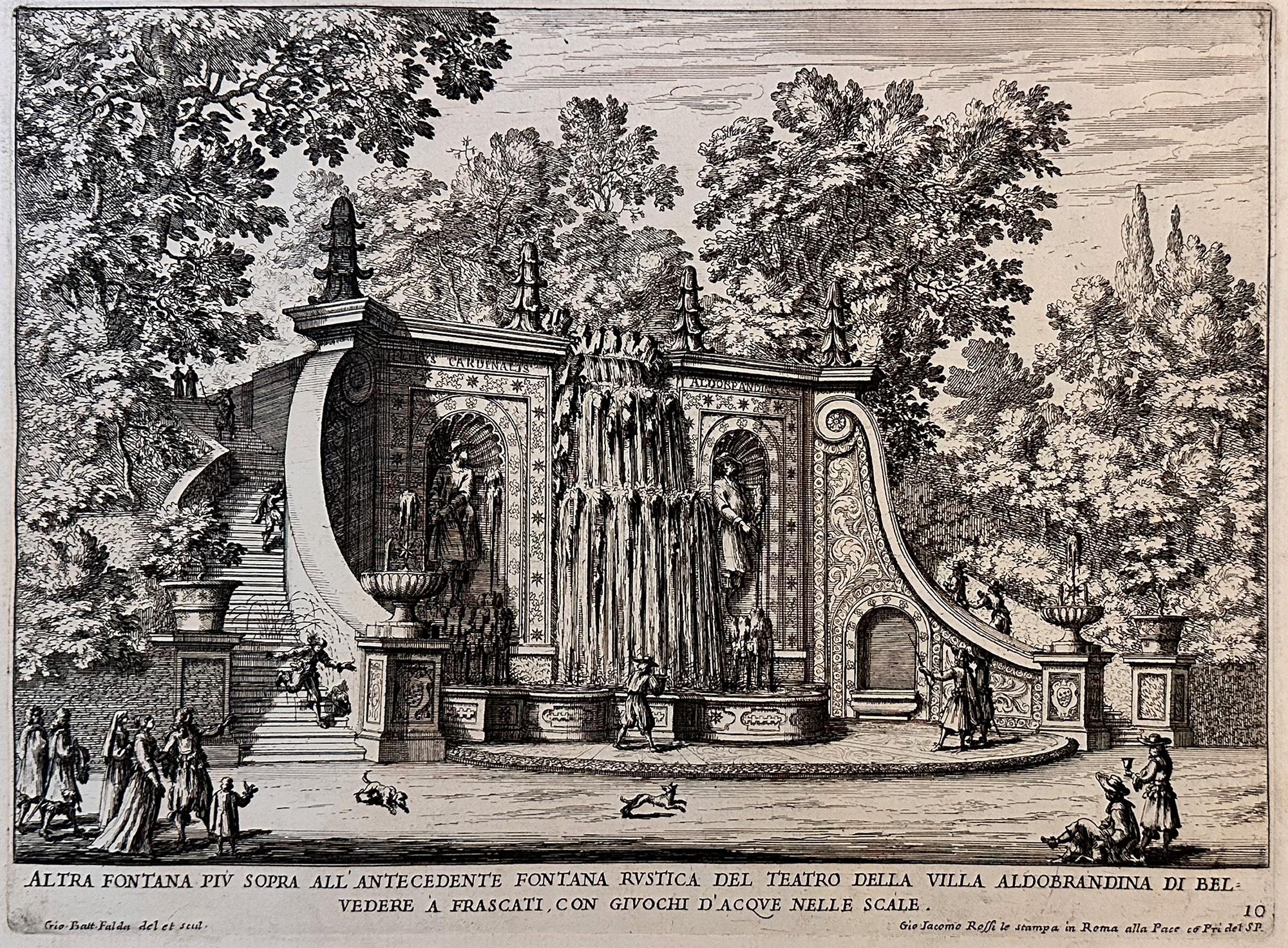
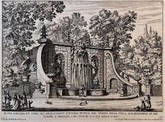
Fountains of Rome
By Giovan Battista Falda
Located in Middletown, NY
A charming scene with romping dogs and spectators watching the cascading water play a trick on an unsuspecting man who is sprayed as he descends the steps, ...
Category
Early 17th Century Old Masters Landscape Prints
Materials
Laid Paper, Engraving, Etching
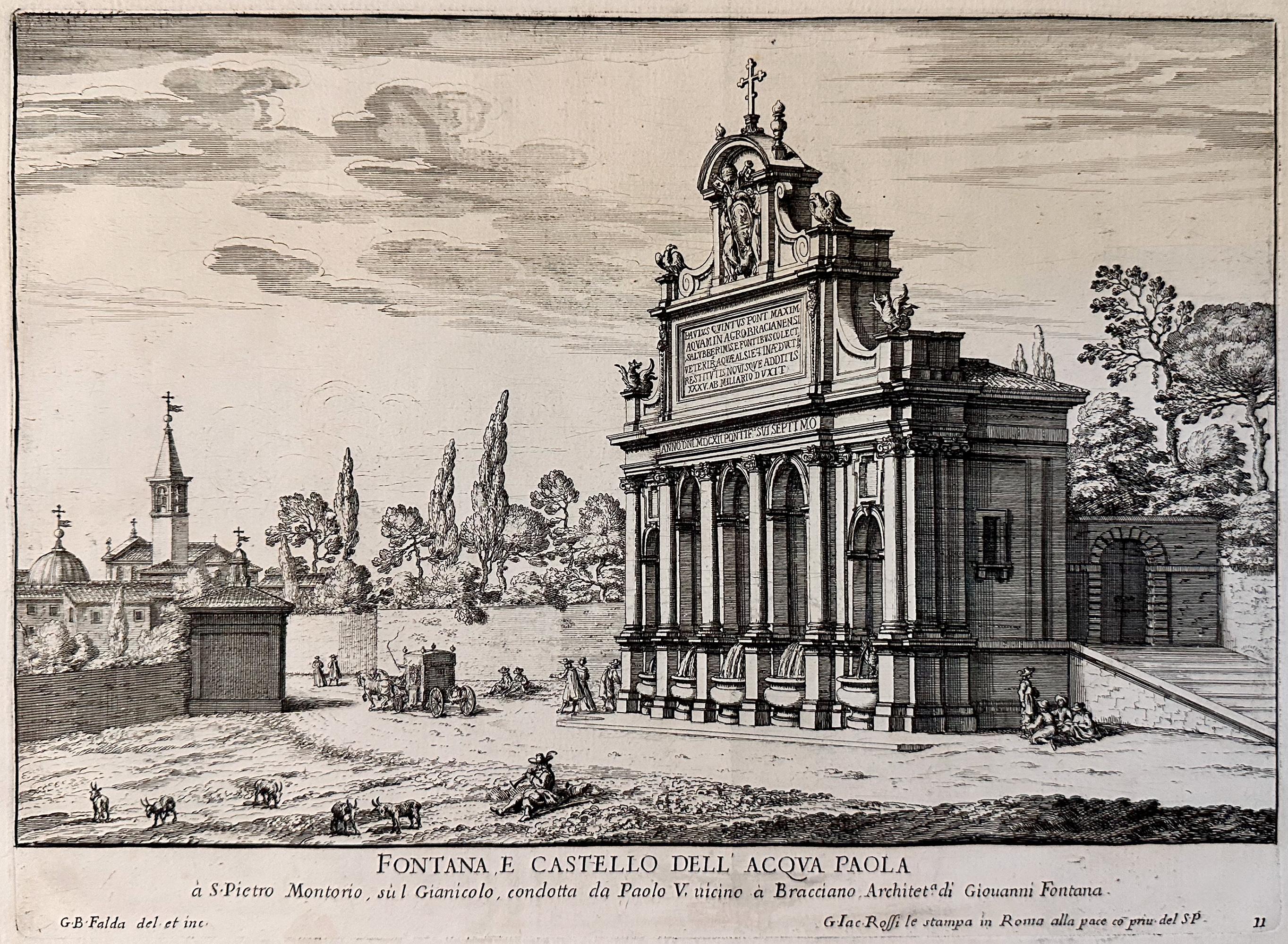
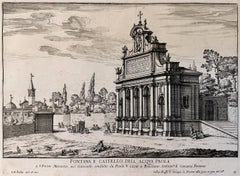
Fountains of Rome; Fontana e castello dell'Acqua
By Giovan Battista Falda
Located in Middletown, NY
Rome: Giovanni Giacomo De Rossi, 1625.
Etching and engraving on cream laid paper, 8 3/8 x 11 1/4 inches (222 x 286 mm), full margins. In good condition with some light yellow discol...
Category
Early 17th Century Old Masters Landscape Prints
Materials
Laid Paper, Engraving, Etching
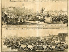
The Queen of Great Britain arriving in Portsmouth 25 May 1662 & The Arrival in L
By Matthäus Merian the Elder
Located in Middletown, NY
Two images of Queen Catharina of Braganza; one before her marriage to King Charles II, the other after, as Queen of Great Britian. Engraved by Matthiäus Merian, father of Maria Sybli...
Category
Mid-17th Century Old Masters Landscape Prints
Materials
Laid Paper, Engraving