Items Similar to Cambridgeshire map 17th century engraving by Kip after Saxton
Want more images or videos?
Request additional images or videos from the seller
1 of 9
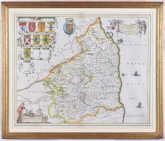
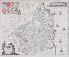
Cambridgeshire map 17th century engraving by Kip after Saxton1637
1637
About the Item
To see more, scroll down to "More from this Seller" and below it click on "See all from this Seller."
William Kip (active 1598 - 1610) after Christopher Saxton (1540 - 1610).
Map of Cambridgeshire (1637)
Engraving with later hand colouring
29 x 32 cm
An antique map of Cambridgeshire. The map was originally published in William Camden's atlas 'Britannia', which was first published in 1586.
William Kip was a goldsmith and map engraver. He was born in Utrecht in the Netherlands and moved to London to pursue his career as an engraver. Alongside William Hole, Kip re-engraved Christopher Saxton's 1574 county maps for publication in Camden's 'Britannia', and it is this venture for which he is most well-known.
Christopher Saxton was an English cartographer who produced the first county maps of England and Wales. Between 1574 and 1578 he engraved maps of every county in Britain, and compiled them into an atlas in 1579. These maps bore Queen Elizabeth I's arms as well as those of Saxton's patron, Thomas Seckford.
- Creation Year:1637
- Dimensions:Height: 11.42 in (29 cm)Width: 12.6 in (32 cm)
- Medium:
- After:Christopher Saxton (1550 - 1610)
- Period:1630-1639
- Framing:Framing Options Available
- Condition:Generally good; faint evidence of old staining.
- Gallery Location:London, GB
- Reference Number:1stDibs: LU795313545622
About the Seller
4.8
Platinum Seller
Premium sellers with a 4.7+ rating and 24-hour response times
Established in 2014
1stDibs seller since 2017
337 sales on 1stDibs
Typical response time: <1 hour
- ShippingRetrieving quote...Shipping from: London, United Kingdom
- Return Policy
Authenticity Guarantee
In the unlikely event there’s an issue with an item’s authenticity, contact us within 1 year for a full refund. DetailsMoney-Back Guarantee
If your item is not as described, is damaged in transit, or does not arrive, contact us within 7 days for a full refund. Details24-Hour Cancellation
You have a 24-hour grace period in which to reconsider your purchase, with no questions asked.Vetted Professional Sellers
Our world-class sellers must adhere to strict standards for service and quality, maintaining the integrity of our listings.Price-Match Guarantee
If you find that a seller listed the same item for a lower price elsewhere, we’ll match it.Trusted Global Delivery
Our best-in-class carrier network provides specialized shipping options worldwide, including custom delivery.More From This Seller
View AllMap of Northumberland by Joan Blaeu
By Joan (Johannes) Blaeu
Located in London, GB
To see our other original maps, scroll down to "More from this Seller" and below it click on "See all from this Seller" - or send us a message if you cannot find the poster you want....
Category
1660s Landscape Prints
Materials
Engraving
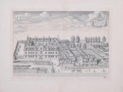
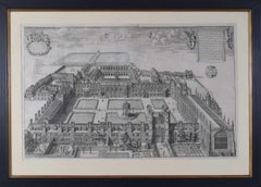
Pembroke College, Oxford 1705 engraving by David Loggan
By David Loggan
Located in London, GB
To see our other views of Oxford and Cambridge, scroll down to "More from this Seller" and below it click on "See all from this seller" - or send us a message if you cannot find the view you want.
David Loggan (1634 - 1692)
Pembroke College, Oxford (1705)
Engraving
31 x 44 cm
Loggan's view of Pembroke from the second edition of the 'Oxonia Illustrata'.
Loggan was born to English and Scottish parents, and was baptised in Danzig in 1634. After studying engraving in Danzig with Willem Hondius (1598-1652 or 1658), he moved to London in the late 1650s, going on to produce the engraved title-page for the folio 1662 Book of Common Prayer. He married in 1663 and moved to Nuffield in Oxfordshire in 1665. Loggan was appointed Public Sculptor to the nearby University of Oxford in the late 1660s, having been commissioned to produce bird’s-eye views of all the Oxford colleges. He lived in Holywell Street as he did this. The 'Oxonia Illustrata' was published in 1675, with the help of Robert White (1645-1704). Following its completion, Loggan began work on his equivalent work for Cambridge; the 'Cantabrigia Illustrata' was finally published in 1690, when he was made engraver to Cambridge University.
The 'Oxonia Illustrata' also includes an engraving of Winchester College (Winchester and New College share William of Wykeham as their founder) whilst the 'Cantabrigia Illustrata' includes one of Eton College (which shares its founder, Henry VIII, with King’s College).
Bird’s-eye views from this era required a particular talent as an architectural perspectivist; it was not until 1783 that it became possible for artists to ascend via hot air balloons and view the scenes they were depicting from above. Loggan thus had to rely on his imagination in conceiving the views.
Loggan’s views constitute the first accurate depictions of the two Universities, in many ways unchanged today. Whilst the Oxford engravings were produced in reasonable numbers and ran to a second edition by Henry Overton (on thicker paper and with a plate number in Roman numerals in the bottom right-hand corner), those of Cambridge were printed in much smaller numbers.
The Dutchman Pieter van der Aa published some miniature versions of the engravings for James Beverell’s guidebook to the UK, 'Les Delices de la Grande Bretagne' (circa 1708). The contemporary artist Andrew Ingamells...
Category
1670s Realist Landscape Prints
Materials
Engraving
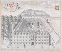
Trinity College, Cambridge engraving by David Loggan
By David Loggan
Located in London, GB
To see our other views of Oxford and Cambridge, scroll down to "More from this Seller" and below it click on "See all from this seller" - or send us a message if you cannot find the view you want.
David Loggan (1634 - 1692)
Trinity College, Cambridge (1690)
Engraving
80 x 50 cm
Loggan's marvellous and large view of Trinity from the 'Cantabrigia Illustrata'.
Loggan was born to English and Scottish parents, and was baptised in Danzig in 1634. After studying engraving in Danzig with Willem Hondius (1598-1652 or 1658), he moved to London in the late 1650s, going on to produce the engraved title-page for the folio 1662 Book of Common Prayer. He married in 1663 and moved to Nuffield in Oxfordshire in 1665. Loggan was appointed Public Sculptor to the nearby University of Oxford in the late 1660s, having been commissioned to produce bird’s-eye views of all the Oxford colleges. He lived in Holywell Street as he did this. The 'Oxonia Illustrata' was published in 1675, with the help of Robert White (1645-1704). Following its completion, Loggan began work on his equivalent work for Cambridge; the 'Cantabrigia Illustrata' was finally published in 1690, when he was made engraver to Cambridge University.
The 'Oxonia Illustrata' also includes an engraving of Winchester College (Winchester and New College share William of Wykeham as their founder) whilst the 'Cantabrigia Illustrata' includes one of Eton College (which shares its founder, Henry VIII, with King’s College).
Bird’s-eye views from this era required a particular talent as an architectural perspectivist; it was not until 1783 that it became possible for artists to ascend via hot air balloons and view the scenes they were depicting from above. Loggan thus had to rely on his imagination in conceiving the views.
Loggan’s views constitute the first accurate depictions of the two Universities, in many ways unchanged today. Whilst the Oxford engravings were produced in reasonable numbers and ran to a second edition by Henry Overton (on thicker paper and with a plate number in Roman numerals in the bottom right-hand corner), those of Cambridge were printed in much smaller numbers.
The Dutchman Pieter van der Aa published some miniature versions of the engravings for James Beverell’s guidebook to the UK, 'Les Delices de la Grande Bretagne' (circa 1708). The contemporary artist Andrew Ingamells...
Category
1690s Realist Landscape Prints
Materials
Engraving
Map of Oxfordshire coloured 18th century engraving by Thomas Kitchin
By Thomas Kitchin
Located in London, GB
To see our other original maps, scroll down to "More from this Seller" and below it click on "See all from this Seller" - or send us a message if you cannot find the poster you want....
Category
1760s Landscape Prints
Materials
Engraving

Map of Northumberland by Joannem Janssonium 17th century
Located in London, GB
To see our other original maps, scroll down to "More from this Seller" and below it click on "See all from this Seller" - or send us a message if you cannot find the poster you want....
Category
1640s Landscape Prints
Materials
Engraving
Clare College, Cambridge 1690 aerial view engraving by David Loggan
By David Loggan
Located in London, GB
To see our other views of Oxford and Cambridge, scroll down to "More from this Seller" and below it click on "See all from this Seller" - or send us a message if you cannot find the ...
Category
1690s Realist Prints and Multiples
Materials
Engraving
You May Also Like
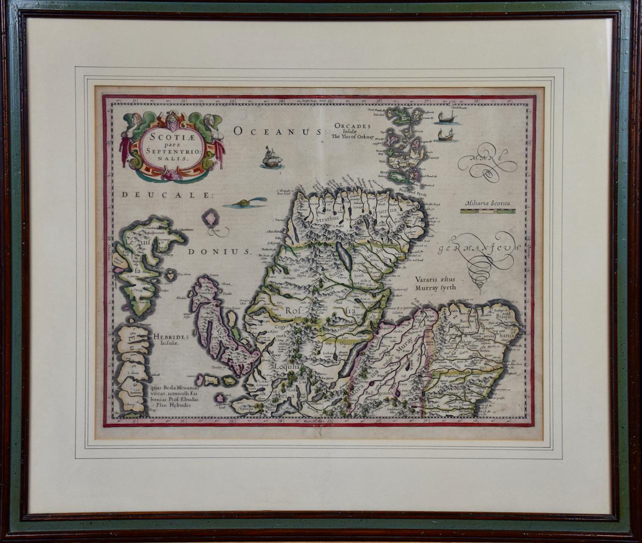
Northern Scotland: 17th Century Hand-colored Map by Mercator
By Gerard Mercator
Located in Alamo, CA
This is a framed hand-colored 17th century map of Northern Scotland by Gerard Mercator entitled "Scotiae pars Septentrionalis", published in Amsterdam in 1636. It is a highly detailed map of the northern part of Scotland, with the northwest Highlands and the cities Inverness and Aberdeen, as well as the Orkney Islands and the Hebrides. There is a decorative title cartouche in the upper left corner.
The map is presented in an antiqued brown wood...
Category
Mid-17th Century Other Art Style Landscape Prints
Materials
Engraving

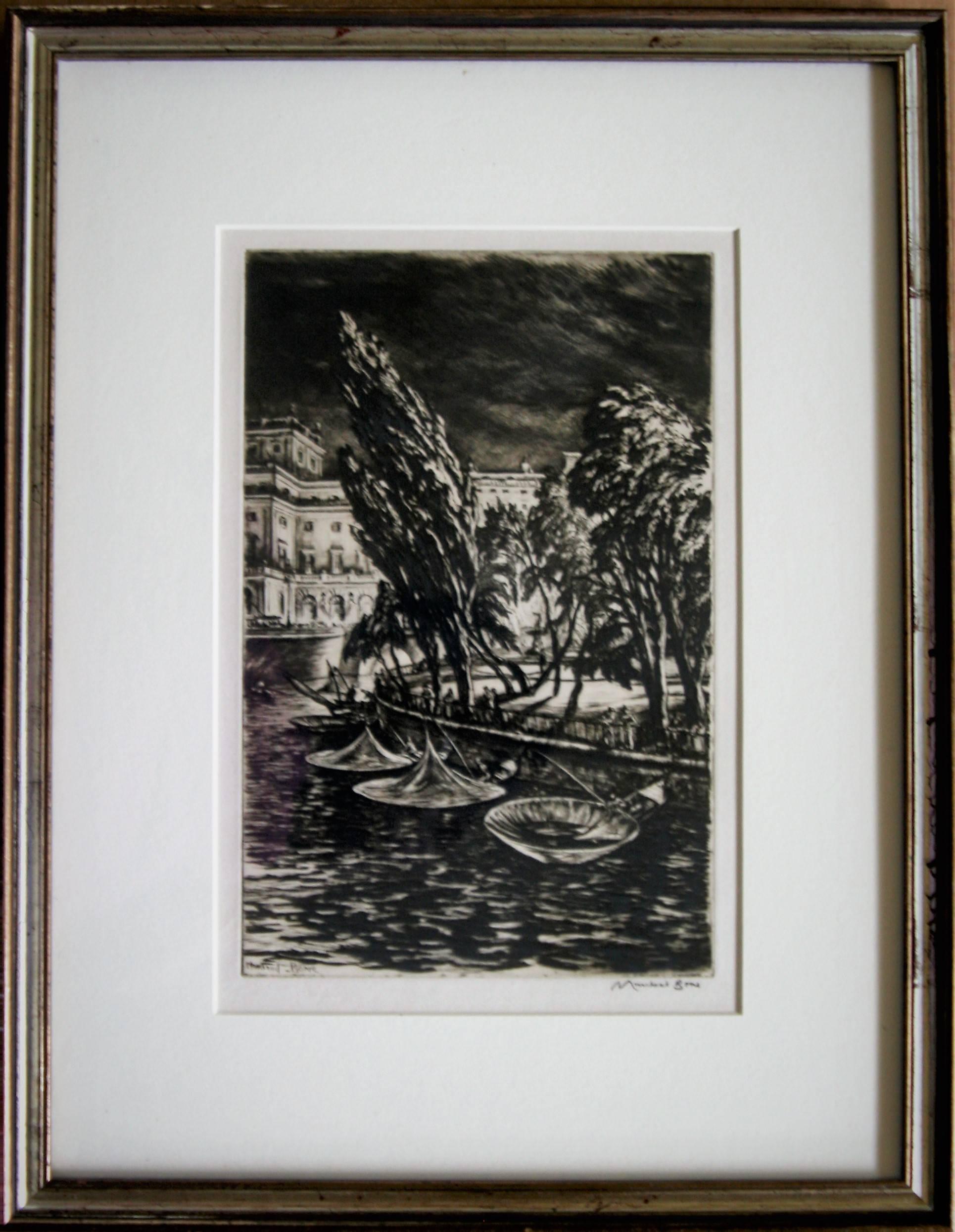
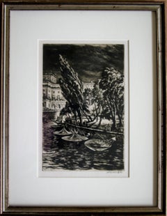
Windy Night, Stockholm.
By Sir Muirhead Bone
Located in Storrs, CT
Windy Night, Stockholm. 1935. Drypoint. Dodgson 457.x. 11 7/8 x 7 5/8 (sheet 15 1/2 x 10 7/8). Edition of 80 in this state (total 93 in 10 states). Illustrated: Guichard, British Etc...
Category
1930s Modern Landscape Prints
Materials
Etching, Drypoint
$1,600 Sale Price
20% Off
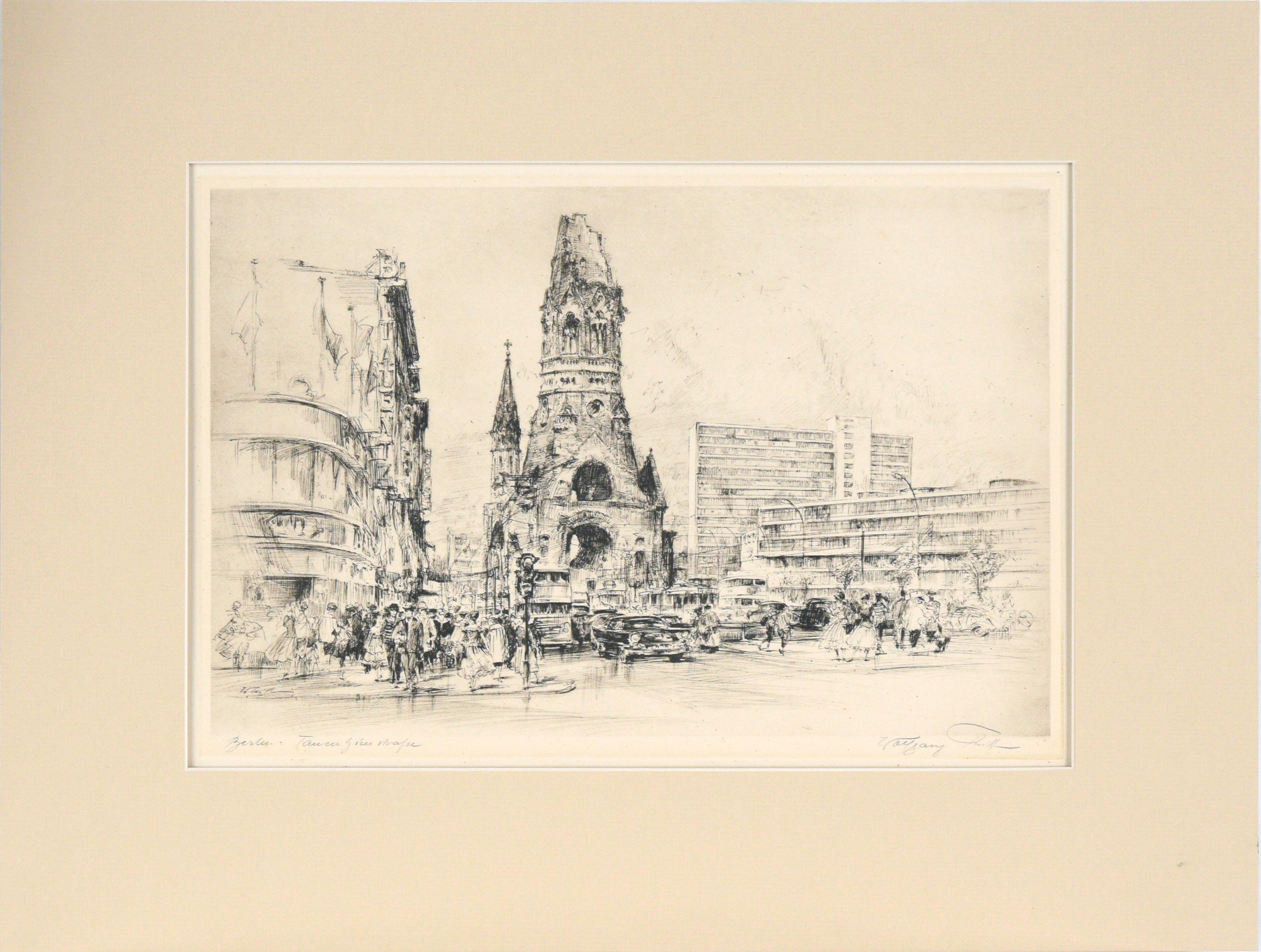
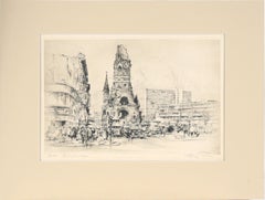
Kaiser Wilhelm Memorial Church in Berlin - Drypoint Etching on Paper
Located in Soquel, CA
Kaiser Wilhelm Memorial Church in Berlin - Drypoint Etching on Paper
Detailed drypoint etching by Wolfgang Tritt (German, 1913-1983). The Kaiser Wilhel...
Category
Mid-20th Century Impressionist Landscape Prints
Materials
Paper, Ink, Drypoint
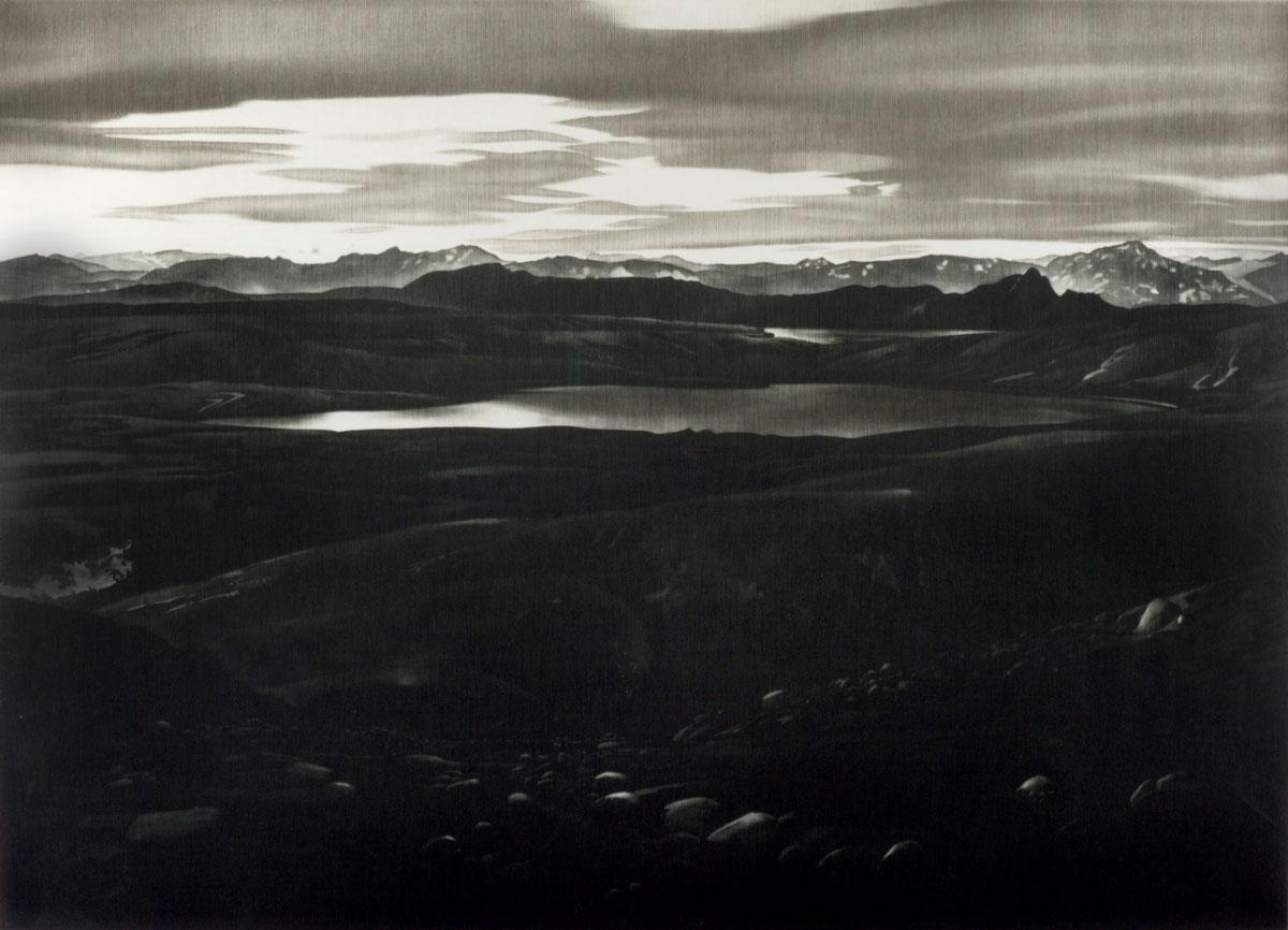
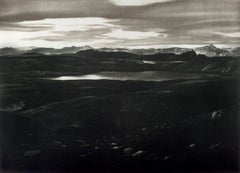
The Lake
By Udo Claassen
Located in New Orleans, LA
German artist Udo Claassen created a dramatic landscape of this Icelandic scene in 1985 in an edition of 40. This is #33.
Claassen was born in Itzehoe in the state of Schleswig-Hol...
Category
Late 20th Century Contemporary Landscape Prints
Materials
Mezzotint
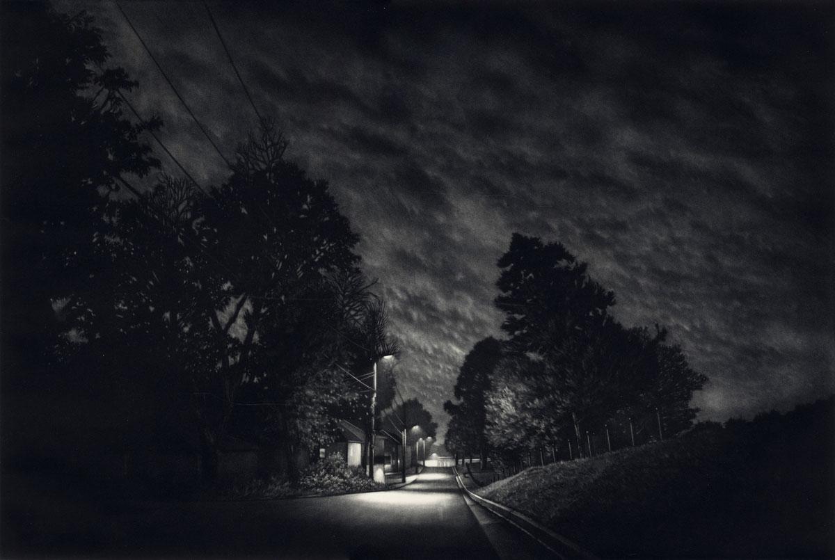
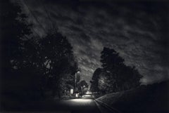
Drift (dramatic nocturne in America's suburbia)
By Jacob Crook
Located in New Orleans, LA
Drift is a hand-pulled mezzotint in an edition of 10. This is #3/10. Location is Jarnigan ST in Starksville, Mississippi
Jacob Crook was born in St. Loui...
Category
2010s American Modern Landscape Prints
Materials
Mezzotint
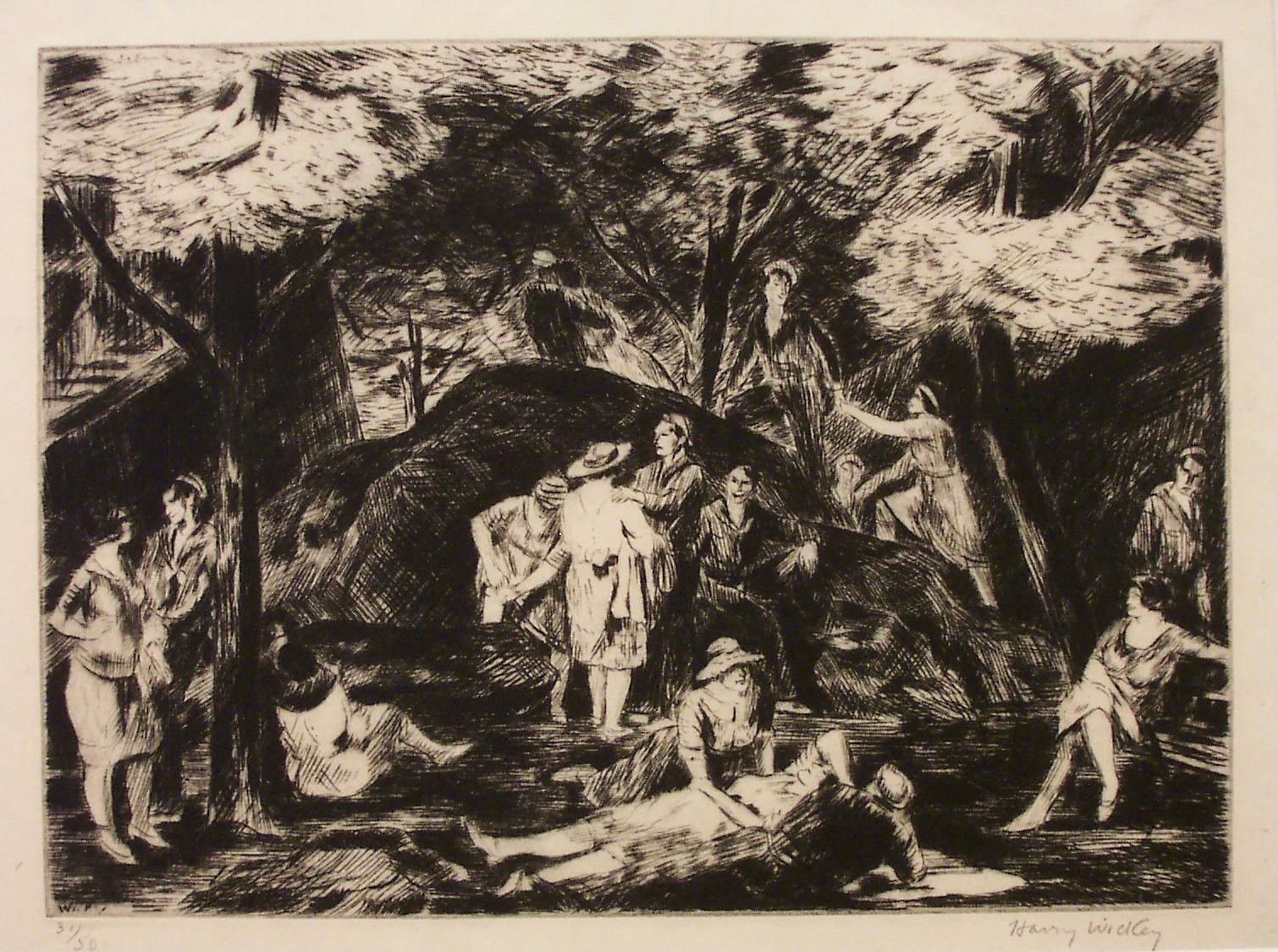
Harry Wickey, Snug Harbor (Riverside Drive, NYC)
By Harry Wickey
Located in New York, NY
The sailors are still in uniform in this post-World War I print of young people meeting at a semi-secluded park setting, Snug Harbor, along Riverside Drive...
Category
1920s Ashcan School Figurative Prints
Materials
Drypoint
