Items Similar to North America: A Framed Hand-colored 19th Century German Map by Adolph Stieler


Want more images or videos?
Request additional images or videos from the seller
1 of 13
Adolf StielerNorth America: A Framed Hand-colored 19th Century German Map by Adolph Stieler1832
1832
About the Item
This framed early 19th century map of North America entitled "Nord-Amerika" is plate No. LIV (No. 46) from Adolph Stieler's Hand-Atlas, published in Gotha, Germany by Justus Perthes in 1832. The original title of the publication was 'Hand-Atlas über alle Theile der Erde und über das Weltgebäude' (Handy Atlas of all Parts of the World and of the Universe).
The map depicts eastern portions of Russia and the adjacent Aleutian Islands and Alaska which are identified as Russian territories. California, Arizona, New Mexico and much of Texas are still part of Mexico. The "Oregon District" includes the modern day state of Washington. Much of the central portions of the United States are identified as Native American regions such as The Sioux District, The Mandan District, The Ozark District, The Huron District and The Osage District. The map does include Canada, Mexico, Central America, Cuba, Jamaica, Haiti, Santa Domingo (the Dominican Republic) , the West Indies and portions of Greenland and South America. Along the California coast, Mendocino, Monterrey, Santa Barbara, San Diego, Santa Catalina Island are identified, San Francisco and Los Angeles were not included.
The map is hand-colored in outline. It is presented in a light brown distressed bleached wood frame with a cream-colored mat. The frame measures 19.5" high x 22" wide x 0.88" deep. There is a central vertical fold, as issued. The map is in very good condition. The mat is somewhat toned.
There are two other 19th century maps of North America (the United States and one including Mexico) listed on 1stdibs that are presented in identical style frames and mats. They can be seen by entering their reference #'s (LU5206222080792 or LULU5206221574182) in the search field. These would make an interesting and attractive grouping. A discount is available for purchase of a grouping of two or three of these maps.
Adolf Stieler (1775-1836) was a German cartographer and lawyer. He was the main cartographer in Justus Perthes' Geographical Institute in Gotha, Germany. He served in the German government for his entire career, but maintained an interest in cartography and published many prominent works, including his Hand-Atlas, which was the leading German world atlas until the middle of the 20th century.
About the Seller
5.0
Platinum Seller
Premium sellers with a 4.7+ rating and 24-hour response times
Established in 2011
1stDibs seller since 2019
281 sales on 1stDibs
Typical response time: 2 hours
- ShippingRetrieving quote...Shipping from: Alamo, CA
- Return Policy
Authenticity Guarantee
In the unlikely event there’s an issue with an item’s authenticity, contact us within 1 year for a full refund. DetailsMoney-Back Guarantee
If your item is not as described, is damaged in transit, or does not arrive, contact us within 7 days for a full refund. Details24-Hour Cancellation
You have a 24-hour grace period in which to reconsider your purchase, with no questions asked.Vetted Professional Sellers
Our world-class sellers must adhere to strict standards for service and quality, maintaining the integrity of our listings.Price-Match Guarantee
If you find that a seller listed the same item for a lower price elsewhere, we’ll match it.Trusted Global Delivery
Our best-in-class carrier network provides specialized shipping options worldwide, including custom delivery.More From This Seller
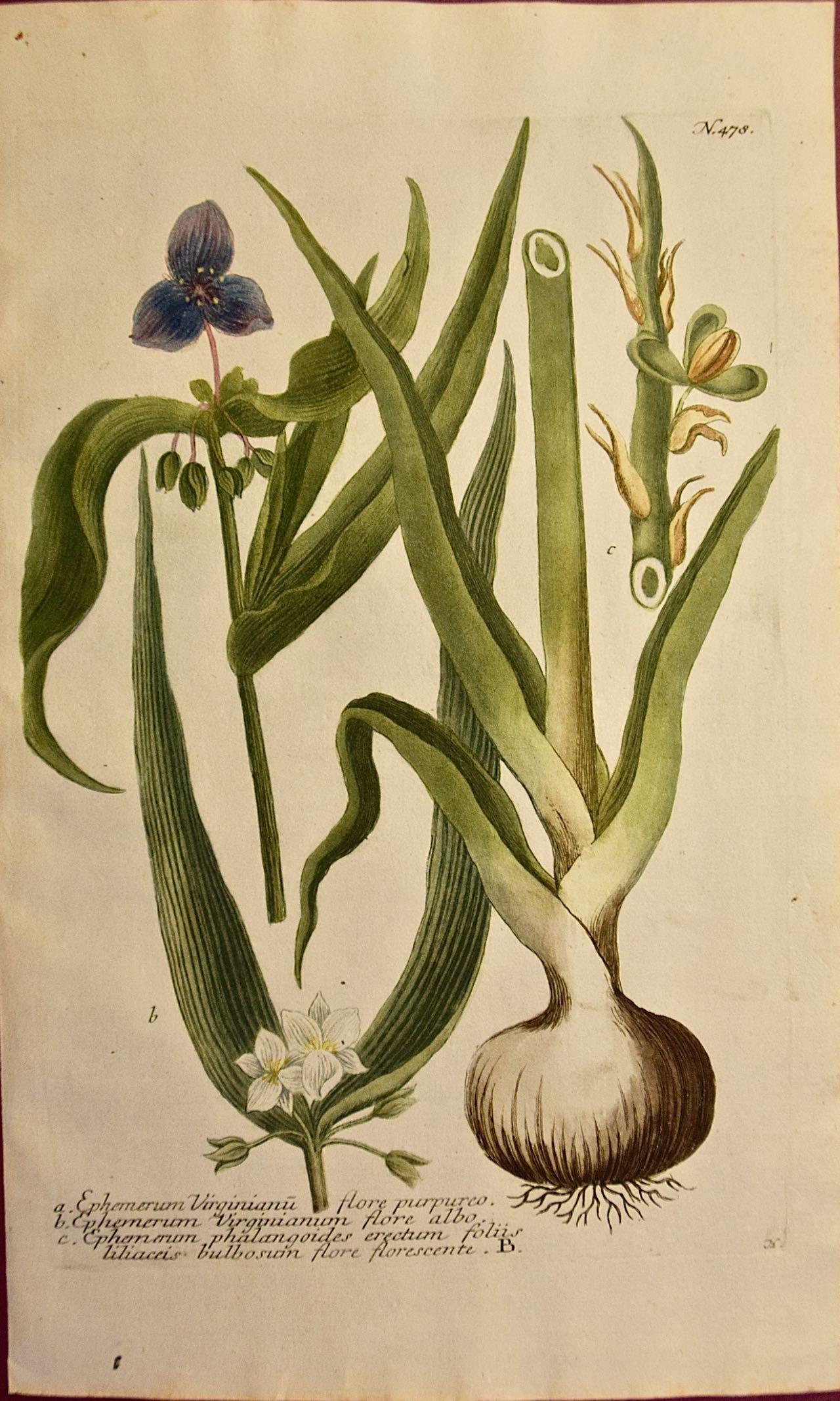
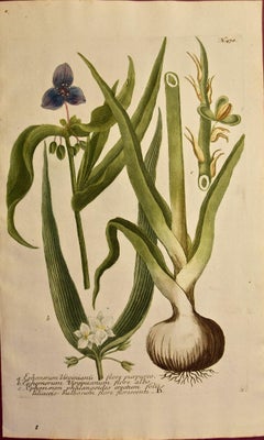
View AllSpider Lily: An Original 18th C. Hand-colored Botanical Engraving by J. Weinmann
By Johann Wilhelm Weinmann
Located in Alamo, CA
This colored botanical mezzotint and line engraving finished with hand coloring by Johann Wilhelm Weinmann (1683-1741) is entitled "A. Ephemerum Virginianu flore Purpureo, B. Ephemer...
Category
Mid-18th Century Naturalistic Still-life Prints
Materials
Engraving, Mezzotint
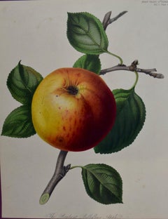
Brabant Apple: A 19th Century Hand-colored Engraving by Augusta Innes Withers
By Augusta Innes Withers
Located in Alamo, CA
This early 19th century hand-colored stipple engraving by Augusta Innes Withers entitled "The Brabant Bellefleur Apple" was plate 10 published in London in the 'Transactions of the H...
Category
1810s Naturalistic Still-life Prints
Materials
Engraving
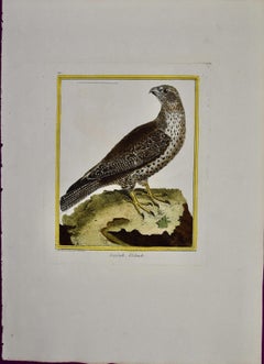
An Icelandic GyrFalcon: An 18th Century Hand-colored Engraving by Martinet
By François Nicolas Martinet
Located in Alamo, CA
This is a hand-colored engraving of an Icelandic Ger Falcon entitled "Gerfault d''Islande" by Francois Nicolas Martinet, plate 210 from 'Histoire Naturelle des Oiseaux' in associatio...
Category
1760s Naturalistic Animal Prints
Materials
Engraving
L'Isle de France: A Hand-colored 17th Century Map by De Wit
By Frederick de Wit
Located in Alamo, CA
This colorful and detailed 17th century hand-colored copperplate map by Frederick De Wit was published in Amsterdam between 1666 and 1760. The map depicts the Île-de-France, which is one of the ancient provinces of France. Paris is located in the center of the map, with Versailles to the southwest The map extends from Rouen in the west to Reims in the east. The area around Paris, the Véxin Français, was the original domain of the king of France. Other areas were ruled by French feudal lords. For example, the Véxin Normand area was the domain of the Duke of Normandy...
Category
Early 18th Century Old Masters More Prints
Materials
Engraving

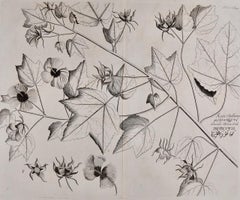
Fever Nut Plant "Ban Caretti": A 17th Century Engraving by Hendrik van Rheede
Located in Alamo, CA
This is a 17th century engraving of a fever or bonduc nut plant entitled "Ban Caretti" by Hendrik van Rheede tot Drakenstein, plate 20 from his 'Hortus Indi...
Category
Late 17th Century Naturalistic Landscape Prints
Materials
Engraving
"Katu-Belluren": A 17th Century Botanical Engraving by Hendrik van Rheede
Located in Alamo, CA
This is a 17th century engraving of a vine spinach plant entitled "Katu-Belluren" by Hendrik van Rheede tot Drakenstein, plate 46 from his 'Hortus Indicus M...
Category
Late 17th Century Naturalistic Landscape Prints
Materials
Engraving
You May Also Like
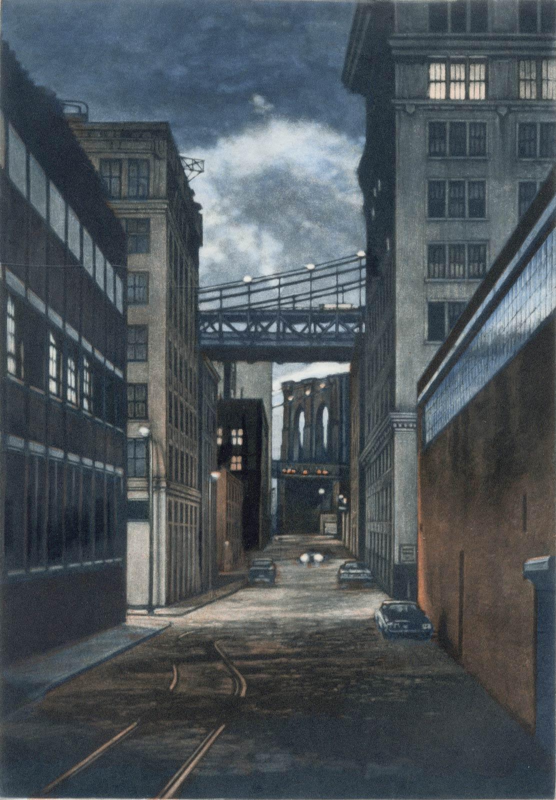
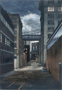
Plymouth Street ( a twilight scene is set in the Brooklyn section of DUMBO)
By Frederick Mershimer
Located in New Orleans, LA
This view of the Brooklyn and Manhattan Bridges is looking down "Plymouth Street" to the intersection of Jay Street. It is #35 in the catalogue raisonne by Retif & Salzer and is in the permanent collection of the Museum of City of New York...
Category
1990s Contemporary Landscape Prints
Materials
Mezzotint, Aquatint
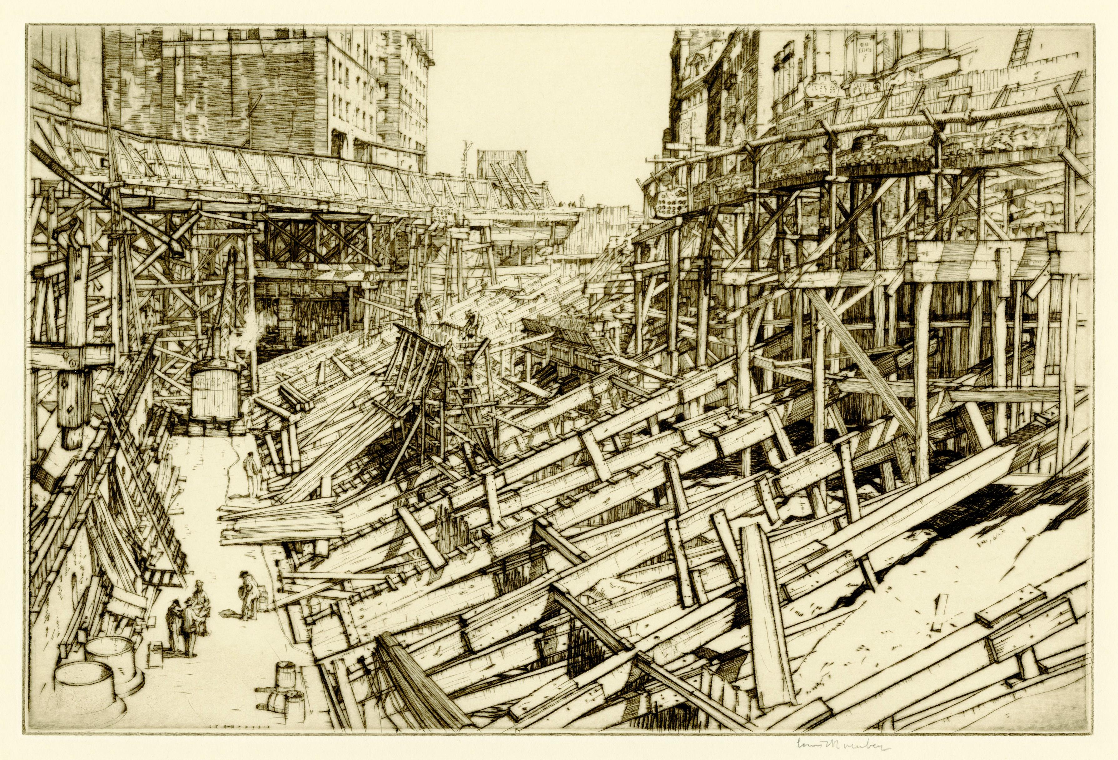
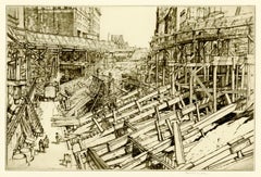
Ontario St. Grading and Temporary Ramps
By Louis Conrad Rosenberg
Located in Fairlawn, OH
Ontario St. Grading and Temporary Ramps
Drypoint, August 1929
Signed in pencil lower right (see photo)
From: The Cleveland Set (23 plates), this being No. 13
Edition: Small
A brilliant example of American industrial art. A wonderful, rich impression, with lots of burr and contrasts.
Louis Conrad Rosenberg
1890-1983
An American architectural etcher and engraver of the 1920's and 1930's era, Louis Conrad Rosenberg first studied at the Massachusetts Institute of Technology. He then enrolled at the Royal College of Art, London, to study etching techniques under Malcolm Osborne...
Category
1920s American Modern Landscape Prints
Materials
Drypoint
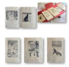
"Peter and the Wolf" - Wolf series with human figure
Located in Miami, FL
Mexican Artists of russian origin, was married to Diego Rivera from 1911 to 1921, the series for sale are illustrations for book, “Peter and the Wolf...
Category
20th Century Modern Animal Prints
Materials
Paper, Engraving
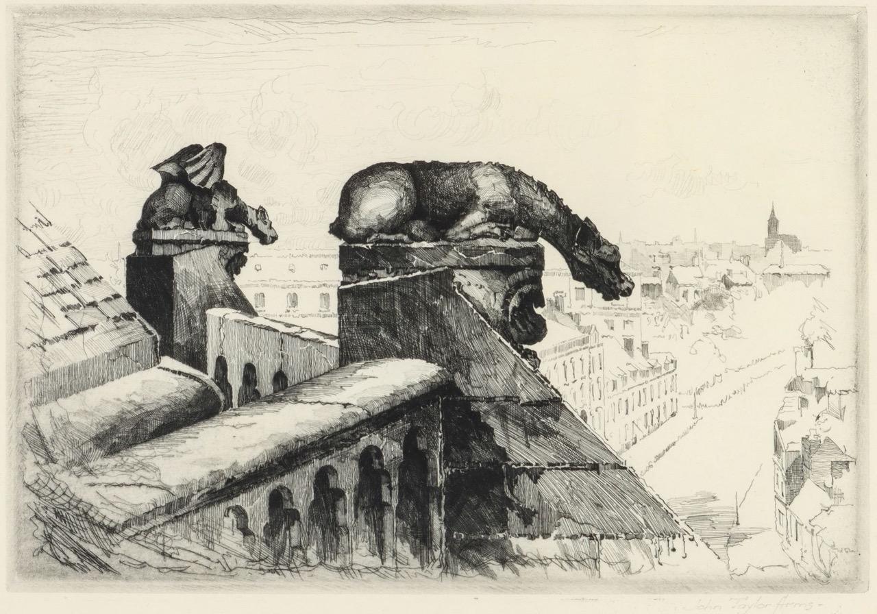
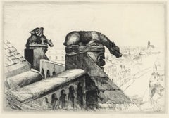
Guardians of the Spire; Amiens Cathedral Number 2
By John Taylor Arms
Located in Middletown, NY
Guardians of the Spire; Amiens Cathedral Number 2
New York: 1937. Etching and drypoint on watermarked F.J. Head cream-colored, antique laid paper, 6 3/4 ...
Category
Mid-20th Century American Modern Figurative Prints
Materials
Drypoint, Etching
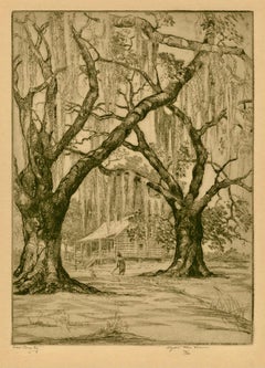
Low Country (South Carolina)
By Elizabeth Verner
Located in Middletown, NY
An enchanting Southern landscape by the mother of the Charleston Renaissance, Elizabeth O'Neill Verner(1883-1979)
Etching and drypoint on cream wove paper, 6 15/16 x 5 1/16 inches (175 x 128 mm), full margins. Signed, titled and numbered 72/100 in pencil, lower margin. Uniform age tone, minor surface soiling. A rich and inky impression of a magical southern landscape with figure tilling soil under Spanish moss covered oaks.
A native of Charleston, South Carolina...
Category
1930s American Modern Landscape Prints
Materials
Drypoint, Etching
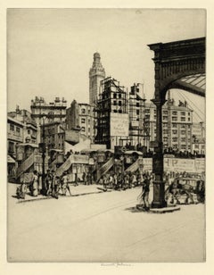
Victoria Station (London)
By Kenneth Holmes, A.R.C.A.
Located in Middletown, NY
A lovely dark and inky impression, signed by the artist.
Drypoint etching on cream laid paper, 10 7/8 x 8 5/8 inches (275 x 218 mm), full margins. Signed in pencil, lower center marg...
Category
Early 20th Century Modern Landscape Prints
Materials
Laid Paper, Drypoint, Etching
Recently Viewed
View AllMore Ways To Browse
Antique Native American Prints
Antique Maps Of North America
Early 19th Century Mexican
Antique Oregon
Cuba Plate
Antiques From Mexico
Antique Map Mexico
Antique Maps California
West Indies Map
Antique Maps Of Canada
California Island Map
Antique Maps West Indies
Cuban Antiques
Map Of Mexican California
Middle Eastern Antiques
Antique Maps Of Texas
West Indies Antiques
Map Of Jamaica